Ensigné
Ensigné is a commune in the Deux-Sèvres department in the Nouvelle-Aquitaine region in western France.
Ensigné | |
|---|---|
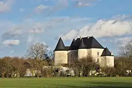 The commandry | |
Location of Ensigné 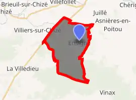
| |
 Ensigné  Ensigné | |
| Coordinates: 46°05′19″N 0°14′35″W | |
| Country | France |
| Region | Nouvelle-Aquitaine |
| Department | Deux-Sèvres |
| Arrondissement | Niort |
| Canton | Mignon-et-Boutonne |
| Government | |
| • Mayor (2008–2014) | Bernard Belaud |
| Area 1 | 20.30 km2 (7.84 sq mi) |
| Population (2017-01-01)[1] | 286 |
| • Density | 14/km2 (36/sq mi) |
| Time zone | UTC+01:00 (CET) |
| • Summer (DST) | UTC+02:00 (CEST) |
| INSEE/Postal code | 79111 /79170 |
| Elevation | 55–149 m (180–489 ft) (avg. 413 m or 1,355 ft) |
| 1 French Land Register data, which excludes lakes, ponds, glaciers > 1 km2 (0.386 sq mi or 247 acres) and river estuaries. | |
Geography
The surrounding countryside is densely wooded. The village is close to the forest of Ensigné and of Aulnay.
The kindergarten and primary school have been merged with those of Asnières-en-Poitou and Paizay-le-Chapt, none of the three individual villages having a population above 300 by the start of the twenty-first century.
History
The history of the village is closely linked to that of the Knights Templar. Ensigné contains a Templar command post comprising fortifications, a chapel and a castle. Today the site is privately owned: the castle itself is in a ruined condition, but two separate properties have been created from the part including the former chapel.
References
- "Populations légales 2017". INSEE. Retrieved 6 January 2020.
| Wikimedia Commons has media related to Ensigné. |