Erie–Meadville, PA Combined Statistical Area
The Erie–Meadville, PA Combined Statistical Area (CSA) is made up of two counties in northwestern Pennsylvania. The United States Office of Management and Budget[1] has recognized the Erie and Meadville areas along with the counties of Erie and Crawford to make a Combined Statistical Area, located in northwestern Pennsylvania. Though these county line boundaries are rather arbitrary since Erie serves as the regional hub for the bordering areas of southwestern New York and northeastern Ohio (including the cities of Jamestown and Conneaut). As of the 2010 United States Census[2] the CSA had a population total of 369,331. The Combined Statistical Area ranked 7th in the state of Pennsylvania and 102nd in the United States.
Erie–Meadville, PA Combined Statistical Area
| |
|---|---|
   | |
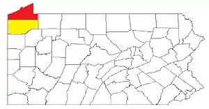 Map of the Erie–Meadville, PA Combined Statistical Area (CSA), composed of the following parts:
| |
| Coordinates: 42.123°N 80.0816°W | |
| Country | United States |
| Commonwealth | Pennsylvania |
| Largest city | Erie |
| Other cities | List
|
| Population (2010) | |
| • Total | 369,331 |
| Time zone | UTC-5 (ET) |
| • Summer (DST) | UTC-4 (EDT) |
Meadville, PA Micropolitan Statistical Area
- Crawford County – population 88,765
Cities/major boroughs
See also
- List of Metropolitan Statistical Areas
- List of Combined Statistical Areas
References
- "Office of Management and Budget | The White House". whitehouse.gov. Retrieved 2014-05-25.
- "2010 Census". census.gov. Archived from the original on 2013-12-21. Retrieved 2014-05-25.
Great Lakes megaregion as defined by RPA | ||
|---|---|---|
Note: A few Great Lakes regions cities in Canada are left out. Metropolitan areas have +150,000 according to source at the time estimated. | ||
| Great Lakes region cities | 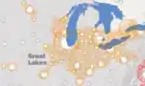 | |
| Surrounding cities |
| |
| Cities of states south of region | ||
| Other metro-regions | ||
This article is issued from Wikipedia. The text is licensed under Creative Commons - Attribution - Sharealike. Additional terms may apply for the media files.