Failsworth
Failsworth, a town in the Metropolitan Borough of Oldham, Greater Manchester, England,[1] lies 3.7 miles (6.0 km) north-east of Manchester city centre and 2.9 miles (4.7 km) south-west of Oldham. The orbital M60 motorway skirts it to the east. The population at the 2011 census was 20,680.[2][3] Historically in Lancashire, Failsworth until the 19th century was a farming township linked ecclesiastically with Manchester.[4] Locals upped their farming income with domestic hand-loom weaving. The humid climate and availability of labour and coal led to mass weaving of textiles, as a Lancashire Mill Town (with redbrick cotton mills). A central landmark is the Failsworth Pole. Daisy Nook is a public country park on the southern boundary with Droylsden.
| Failsworth | |
|---|---|
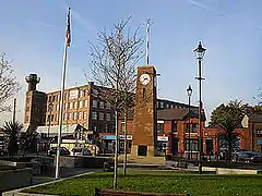 Failsworth Pole | |
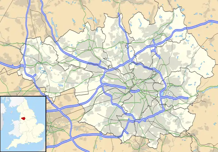 Failsworth Location within Greater Manchester | |
| Population | 20,680 (2011 CensusWards) |
| OS grid reference | SD895015 |
| • London | 163 mi (262 km) SSE |
| Metropolitan borough | |
| Metropolitan county | |
| Region | |
| Country | England |
| Sovereign state | United Kingdom |
| Post town | MANCHESTER |
| Postcode district | M35 |
| Dialling code | 0161 |
| Police | Greater Manchester |
| Fire | Greater Manchester |
| Ambulance | North West |
| UK Parliament | |
Etymology
Failsworth derives from the Old English fegels and worth, probably meaning an "enclosure with a special kind of fence".[5]
History
Early settlement rested on a road that runs today between Manchester and Yorkshire. This Roman secondary road formed part of a network from Manchester up north, probably to Tadcaster near York.[6]:5 The section that ran through Failsworth is still known as Roman Road. It was built above marshland and laid on brushwood with a hard surface. Roman Road has also been known as "Street", a Saxon term meaning "metalled road", indicating that it was also used that later period.[6]:5
Early sources suggest the area was occupied in Saxon times.[6]:5 The small hamlet of scattered dwellings made of rough local stone, mud and clay with thatched roofs, may have been stood on ground higher than the surrounding marshland. Daily life would have centred on animal husbandry and agriculture.[6]:5
Unmentioned in the Domesday Book of 1086, Failsworth appears in a record of 1212 as Fayleswrthe, a settlement was documented as a thegnage estate or manor comprising four oxgangs of land. Two oxgangs at an annual rate of 4 shillings were payable by the tenant, Gilbert de Notton, to Adam de Prestwich, who in turn paid tax to King John.[5][7] The other two oxgangs were held by the Lord of Manchester as part of his fee simple. The Byron family came to acquire the whole township in the mid-13th century. Apart from a small estate held by Cockersand Abbey, Failsworth passed to the Chetham family and was then sold on to smaller holders.[7]
By 1663, 50 households were registered.[6]:6 Life centred on natural resources, agriculture and stock farming, with many were employed as labourers to work the land, though tradesmen such as a tailor, a felt maker, a shoemaker, a joiner and a weaver supported them. The earliest record of a place of worship is Dob Lane Chapel, dating from 1698.[6]:6

In 1774, the 242 Failsworth households contained some 1.400 inhabitants,[6]:6 of whom a high proportion were involved in cloth manufacture. Development of the English textile trade was backed by important legislation between 1500 and 1760: a number of acts were passed to encourage it by the compulsory growing of flax. Grants were made to flax growers and duties levied on foreign imports, though Manchester's extensive linen trade used yarn imported from Holland and Ireland.[6]:6
In 1914 the regular Daisy Nook Easter Fair ceased with the outbreak of the First World War, but resumed in 1920. On 8 June 2007, a 1946 work by L. S. Lowry entitled "Good Friday, Daisy Nook" sold for £3,772,000, then the highest bid ever paid for one of his paintings.[8] Another painting by Lowry from 1953, "Fun Fair at Daisy Nook", sold for £3.4 million in 2011.
Timeline
- 1212 – First official record of Failsworth in King John's Great Inquest of Service[6]:66[9]
- 1212 – North-western portion of land held by the Lord of the Manor of Prestwick[6]:66
- 1212 – South-eastern portion of land held by the Lords of the Manor of Manchester[6]:66
- Mid-13th century – Richard and Robert de Byron acquired both portions of land[6]:66
- 1320 – First record of a named place in Failsworth: Wrigley Head named in the Survey of the Manor of Manchester[6]:66
- 1600–1699 – Population mostly working the land and supported by production of cloth[6]:66
- 1660 – 43 names registered in the town[6]:66
- 1663 – 50 recorded families[6]:66
- 1673 – Earliest record of a place of worship: Dob Lane Chapel[6]:66
- 1700–1799 – Most inhabitants involved in producing linen cloth, others farming[6]:66
- 1735 – Manchester, Oldham and Austerlands Turnpike Trust improves the road between them.[6]:66
- 1774 – 242 families recorded, with a population 1,400[6]:66
- 1793 – The first Failsworth Pole erected[6]:66
- 1796 – The earliest day school recorded is Pole Lane School.[6]:66
- 1801 – Population 2,622[6]:66
- 1803 – The main Turnpike Road is widened to 60 feet from Manchester to Dob Lane End.[6]:66
- 1804 – Rochdale Canal opens on 21 December.[6]:66
- 1825 – The first cotton mill built[6]:66
- 1839 – The first mill built by Henry Walmsley[6]:66
- 1844 – Failsworth constitutes a new parish: St John's.[6]:66
- 1850 – A second Failsworth Pole erected[6]:66
- 1851 – Population is 4,433[6]:67
- 1859 – Failsworth Industrial Society is officially registered on 22 July.[6]:67
- 1863 – The first Local Government Board is founded with nine members.[6]:67
- 1878 – Horse-drawn trams are introduced between Manchester and Hollinwood.[6]:67
- 1880 – A railway opens between Oldham and Manchester.[6]:67
- 1881 – Failsworth acquires its first railway station in April.[6]:67
- 1889 – A third Failsworth Pole erected[6]:67
- 1894 – The Local Board is superseded by Failsworth Urban District Council.[6]:67
- 1901 – Population 14,152[6]:67
- 1901 – Electric trams replace the horse-drawn ones.[6]:67
- 1903 – Merger with Manchester proposed[6]:67
- 1904 – Merger with Manchester deferred[6]:67
- 1924 – A fourth Failsworth Pole erected[6]:67
- 1937 – The Roxy cinema presents its first feature on 20 December.[6]:67
- 1946 – Failsworth Urban District Council proceeds with a housing clearance programme.[6]:67
- 1946 – The last tram runs in Oldham.[6]:67
- 1958 – The fifth and present Failsworth Pole erected[6]:67
- 1973 – Failsworth is officially twinned with Landsberg am Lech in Germany.[6]:67
- 1974 – Failsworth becomes part of the Metropolitan Borough of Oldham.[6]:67
- 1991 – Population 20,999[6]:67
- 1993 – The bicentenary of the first Failsworth Pole is marked.[6]:67
- 2000 – The M60 motorway link opens.[6]:67
Governance

Lying within the historic county boundaries of Lancashire since the early 12th century, Failsworth in the Middle Ages formed a township in the parish of Manchester, and hundred of Salford.[1]
After the Poor Law Amendment Act 1834, Failsworth formed part of the Manchester Poor Law Union, a unit founded for social security.[1] Failsworth's first local authority was a local board of health set up in 1863;[1] Failsworth Local Board of Health was responsible for standards of hygiene and sanitation.[1] After the Local Government Act 1894, its area became Failsworth Urban District within the administrative county of Lancashire.[1] In 1933 came a small exchange of land with neighbouring Manchester; in 1954, parts of Limehurst Rural District were added to Failsworth Urban District.[1] Under the Local Government Act 1972, Failsworth Urban District was abolished. Since 1 April 1974 it has formed an unparished area of the Metropolitan Borough of Oldham, a local government district within the metropolitan county of Greater Manchester.[1][10] Failsworth contains two of the twenty wards of the Metropolitan Borough of Oldham; Failsworth East and Failsworth West.
Failsworth lies in Ashton-under-Lyne parliamentary constituency, represented in the House of Commons by Angela Rayner MP of the Labour Party.
Geography
Neighbouring towns, villages and places. | ||||||||||
|---|---|---|---|---|---|---|---|---|---|---|
| ||||||||||
At 53°30′37″N 2°9′27″W (53.5102°, −2.1575°) Failsworth lies 163 miles (262 km) north-north-west of London, as the southern tip of the Metropolitan Borough of Oldham, sharing borders with Manchester (north to south-west) and Tameside (south to east). It is traversed by the A62 road between Manchester and Oldham, by the former rail line of the Oldham Loop and by the Rochdale Canal, across its north-west corner. The M60 motorway passes through. For the Office for National Statistics, Failsworth counts as part of the Greater Manchester Urban Area.[11]
The land in Failsworth slopes gently from east to west away from the Pennines and from brooks that bound it on the north-west (Moston Brook) and south-east (Lord's Brook). Failsworth has a country park, Daisy Nook, on undulating wooded land on its eastern border largely belonging to the National Trust. It is suited to walking, horse riding, fishing and other pursuits.
Demography
Population change
| Population growth in Failsworth since 1901 | ||||||||||
|---|---|---|---|---|---|---|---|---|---|---|
| Year | 1901 | 1911 | 1921 | 1931 | 1939 | 1951 | 1961 | 1981 | 1991 | 2001 |
| Population | 14,152 | 15,998 | 16,973 | 15,726 | 17,505 | 18,032 | 19,819 | 20,951 | 20,160 | 20,007 |
| Source: A Vision of Britain through Time[12][13][14] | ||||||||||
Economy
Failsworth is a centre for hat-making. This began as a cottage industry before the firm of Failsworth Hats was set up in 1903 to manufacture silk hats. For a time the company had a factory near the former Failsworth Council offices and it remains in the area to this day.[15] Other activities include electrical goods manufacture (such as Russell Hobbs) by Spectrum Brands, formerly Pifco Ltd), and plastic production and distribution by Hubron Ltd. Many Failsworth people work in Manchester: the strong transport links include a tram service from Failsworth Metrolink station on the Oldham–Rochdale line.
In July 2007, the Tesco supermarket chain a 24-hour Extra branch on the banks of a regenerated "wharf". The move has not been welcomed by shop-owners, who claim they have lost customers and may be forced to close.[16][17][18][19] Tesco's arrival had been expected to be a catalyst bringing other stores, bars and restaurants to Failsworth.[20] The only other large store is a branch of Morrisons housed in a building constructed on the demolished site of Marlborough No. 2 Mill.[21]
Oldham Caravans, a subsidiary of Glossop Caravans, has an outlet in Oldham Road.
Landmarks
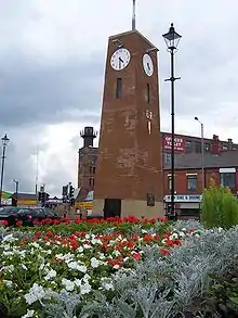
A Failsworth Pole in Oldham Road was first raised in 1793 as a "political pole", although a local historian suggests there were others before and that maypoles probably stood there for centuries. It now stands on a site from which an earlier one blew down in 1950.
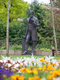
After a major restoration of the Pole, clock tower and gardens in 2006, a bronze statue of Benjamin Brierley was placed in the gardens.[22]
At the road junction of the A62 with Ashton Road West stands a cenotaph built in 1923 for over 200 Failsworth men who lost their lives in the First World War. Attendances at the cenotaph on Remembrance Sunday remain high at about 2,000.[23] The annual parade is led by 202 Field Squadron, RE (TA),[24] which is based in Failsworth. In June 2007 the war memorial was rededicated after a £136,000 makeover and opened by Colonel Sir John B. Timmins.
Education
The local comprehensive school is Co-op Academy Failsworth, which moved to a new building in 2008 from two buildings known as Upper School and Lower School. It caters for students aged between 11 and 16. The £28-million project brought the town's secondary schooling to come under one roof. It has specialist sports college status.[25]
| School | Type/Status | Headteacher | OfSTED | Location | Reference |
|---|---|---|---|---|---|
| Co-op Academy Failsworth | Secondary School | Mr P Quirk | 105735 | 53.507620°N 2.146614°W | [26] |
| Woodhouses VA Primary School | Primary School | R Bentham | 105688 | 53.504482°N 2.134096°W | [27] |
| South Failsworth Community Primary School | Primary School | Mrs Foy | 105656 | 53.499164°N 2.158921°W | [28] |
| Higher Failsworth Primary School | Primary & Infant School | Susan Kitchen | 134784 | 53.514258°N 2.148734°W | [29] |
| St John's CE Primary School | Primary School | 53.510729°N 2.153525°W | |||
| St John's CE Primary School | Primary School | Gerard Kehoe | 105712 | 53.508982°N 2.150887°W | [30] |
| St Mary's RC Primary School | Primary & Infant School | Bernadette Cunningham | 105727 | 53.504745°N 2.159996°W | [31] |
| Mather Street Primary School | Primary School | J Adams | 105649 | 53.509585°N 2.168270°W | [32] |
| Pupil Support Centre | Special School | Nikki Shaw | 53.509585°N 2.168270°W | [33][34] |
Religious sites
| Name | Denomination | Leader | Location | Reference |
|---|---|---|---|---|
| The Holy Family | Church of England | Fr Paul Hutchins | 53.497918°N 2.157408°W | [35] |
| St John's | Church of England | 53.511781°N 2.154473°W | [35] | |
| Woodhouses Church | Church of England | 53.504885°N 2.133061°W | [36] | |
| St Mary's | Roman Catholic | Fr Patrick John McKeown | 53.504623°N 2.157416°W | [37] |
| Hope Methodist Church | Methodist | 53.515147°N 2.151141°W | [39] | |
| Roman Road Independent Methodist Church | Independent Methodist | Clifford Ward | 53.511163°N 2.149825°W | [40] |
| New Life Church | Assemblies of God | Elijah Boswell (Pastor) Jack Kenyon Andrew Black David Newberry | 53.511237°N 2.153803°W | [41] |
| Dob Lane Unitarian Chapel | Unitarianist | 53.504194°N 2.176965°W | [42] | |
| Macedonia | United Reformed Church | Rev Sheila Coop | 53.508652°N 2.143494°W | [43] |
| Zion | Old Baptist Union | 53.501869°N 2.163218°W | [44] | |
| Faithworks | Evangel | 53.506373°N 2.166806°W | [44] | |
| Failsworth Salvation Army Community Church | The Salvation Army | Lieutenants Simon & Victoria Rowney | 53.513441°N 2.152605°W | [45] |
Transport

Failsworth's main thoroughfare is Oldham Road (A62) between Manchester and Oldham. The M60 is an orbital motorway circling Greater Manchester, with access via Junction 22. Its completion around 1995–2000 saw the installation of a graded junction and other notable changes to the A62. It led to several rows of buildings around the junction being demolished.
There are frequent buses through Failsworth between Manchester city centre and Oldham on First Greater Manchester's 83 overground service. There is also a frequent service to Manchester city centre and to Huddersfield/Saddleworth via Oldham, with services 180 and 184. Other bus destinations from Failsworth are Ashton-under-Lyne, Chadderton, Huddersfield, Rochdale, Royton, Saddleworth, Shaw & Crompton and Trafford Centre.
Failsworth tram stop in Hardman Lane is on the Oldham & Rochdale line of the Manchester Metrolink. At peak times, trams run every 6 minutes south towards East Didsbury via central Manchester and north to Shaw & Crompton or Rochdale via Oldham. At off-peak times, trams run every 12 minutes to East Didsbury and Rochdale.[46] Previously this was an unmanned rail station on the Oldham Loop line serviced by Northern Rail services to Manchester Victoria or Rochdale via Oldham.[47] It closed in October 2009 under Phase 3a of Metrolink extension and re-opened as a tram stop in 2012.[48]
Twin town
| Country | Place | County / District / Region / State | Originally twinned with | Date | |||
|---|---|---|---|---|---|---|---|
| (Germany) | Landsberg am Lech | Bavaria | Failsworth Urban District | 1974–2008[49] |
Notable people
- In 1745, "Bonnie Prince Charlie" stayed overnight at the Bull's Head public house.[50]
- The weaver, poet, essayist and writer Benjamin Brierley was born in Failsworth and famed for his work in the Lancashire dialect. A statue of him was erected in 1898 in Queens Park, Manchester. There is a bronze statue of him is in the public gardens by The Pole.[51]
- In politics, Sir Elkanah Armitage was a 19th-century industrialist, Liberal Party politician and former Lord Mayor of Manchester.[52][53]
- In present-day politics, Jim McMahon MP represents the Oldham West and Royton parliamentary constituency for the Labour Party. He was formerly leader of Oldham Council
- Gary Mounfield is a musician who formerly with the band the Stone Roses during the Madchester period and later joined Primal Scream.[54][55]
- Dale Longworth is a musician and producer with the electronic music group, N-Trance, which found fame with the record Set You Free.[56] James Mudriczki, Lowell Killen, Kevin Matthews, Tony Szuminski (and former member Neil McDonald) make up the line-up for the Alternative rock band Puressence.
- The Lancashire folk singer Harry Boardman was born in Failsworth.
- The Broadcaster, journalist and cricketer Mike Atherton, was brought up in the Lord Lane area of town. The former Lancashire and England captain has a road, Atherton Close, named after him, opposite the cricket club in Woodhouses where he played in his youth.[57][58][59]
- Boxer Anthony Farnell, is a former WBU Middleweight champion known as the Woodhouse Warrior.[60][61] Retiring at 25, Farnell has since become a fight trainer and owns a gym (Arnie's Gym) in nearby Newton Heath, where he has tutored David Barnes (BBBofC Light welterweight champion), Anthony Crolla (2006 ABA Lightweight champion)[62] and Frankie Gavin (2007 World Amateur Boxing Championships gold medal winner).[63]
- Former Manchester United footballer Ronnie Wallwork lived in Woodhouses.
- Supermodel Agyness Deyn was brought up in the area before her family moved to Ramsbottom.[64]
- Masters Athlete Mike Coogan, lived in Failsworth, attending St Mary's RC Primary School. He was the 2019 British, European and World 200m Champion.[65]
See also
References
- "Greater Manchester Gazetteer". Greater Manchester County Record Office. Places names – D to F. Archived from the original on 18 July 2011. Retrieved 9 July 2007.
- "Oldham Ward/Failsworth West Ward population 2011". Retrieved 6 January 2016.
- "Oldham Ward/Failsworth East ward population 2011". Retrieved 6 January 2016.
- Lewis 1848, pp. 206–209.
- Mills, A.D. (2003). A Dictionary of British Place-Names. Oxford: Oxford University Press. ISBN 0-19-852758-6. (subscription required)
- Taylor, Sheila (2001). Failsworth Place and People. Oldham: Oldham Arts and Heritage Publications. ISBN 978-0-902809-98-7.
- Brownbill & Farrer 1911, pp. 273–274.
- "Lowry work fetches record £3.8m". BBC News. 8 June 2007. Retrieved 16 January 2008.
- Poole, Austin Lane (1993) [First published 1951]. From Domesday Book to Magna Carta, 1087-1216 (2nd revised ed.). Oxford, England: OUP Oxford. p. 14. ISBN 978-0-19-285287-8 – via Google Books.
- HMSO. Local Government Act 1972. 1972 c. 70.
- Office for National Statistics (2001). "Census 2001:Key Statistics for urban areas in the North; Map 3" (PDF). Government of the United Kingdom. Archived from the original (PDF) on 9 January 2007. Retrieved 9 July 2007.
- "Census 2001 Key Statistics – Urban area results by population size of urban area". Government of the United Kingdom. 22 July 2004. KS01 Usual resident population
 . Retrieved 22 September 2009.
 - "Greater Manchester Urban Area 1991 Census". National Statistics. Archived from the original on 5 February 2009. Retrieved 22 September 2009. Cite journal requires
|journal=(help) - "1981 Key Statistics for Urban Areas: The North Table 1". Office for National Statistics. 1981. Cite journal requires
|journal=(help) - "Failsworth hats". failsworth-hats. Archived from the original on 17 January 2010. Retrieved 11 February 2010. Cite journal requires
|journal=(help) - "Tesco's killing us say small traders". Oldham Advertiser. M.E.N. Media. 23 August 2007. Retrieved 13 February 2012.
- Conn, David (25 July 2007). "Supermarket sweep-up". The Guardian. London.
- Richardson, Anne (12 November 2003). "Tesco target Failsworth". Oldham Advertiser. M.E.N. Media. Retrieved 13 February 2012.
- Akbor, Ruhubia (6 February 2008). "Failsworth's £30m new look". Oldham Advertiser. M.E.N. Media. Retrieved 13 February 2012.
- Conn, David (8 October 2008). "Buying into it". The Guardian. London.
- "Chingford Store details". Morrisons. Retrieved 13 February 2012.
- J. McMahon and J. Crompton, The History of Failsworth Pole and the Ben Brierley Statue published June 2006.
- (PDF). 27 March 2009 https://web.archive.org/web/20090327160544/http://www.oldham.gov.uk/jan09failsworth.pdf. Archived from the original (PDF) on 27 March 2009. Missing or empty
|title=(help) - "Archived copy". Archived from the original on 11 February 2009. Retrieved 27 October 2008.CS1 maint: archived copy as title (link)
- Archived 25 May 2009 at the Wayback Machine
- "Failsworth School". School Finder. OfSTED. Retrieved 2 March 2009.
- "Woodhouses Voluntary (Controlled) Primary School". School Finder. OfSTED. Retrieved 2 March 2009.
- "South Failsworth County Primary School". School Finder. OfSTED. Retrieved 1 November 2008.
- "Higher Failsworth (Stansfield Road) Infants School". School Finder. OfSTED. Retrieved 2 March 2009.
- "St. John's C of E Junior School". School Finder. OfSTED. Retrieved 2 March 2009.
- "St. Mary's R.C. Primary School". School Finder. OfSTED. Retrieved 2 March 2009.
- "Mather Street Primary School". School Finder. OfSTED. Retrieved 1 November 2008.
- "Hardman Fold Community Special School Oldham: Read Parent Reviews & Rankings". Schoolsnet.com. 17 March 2009. Retrieved 13 February 2012.
- Ferguson, James (3 November 2004). "Pupils return to troubled school". Oldham Advertiser. M.E.N. Media. Retrieved 13 February 2012.
- "Oldham Deanery – The Church of England Diocese of Manchester". Manchester.anglican.org. Retrieved 13 February 2012.
- Archived 12 September 2008 at the Wayback Machine
- Cooke, Fr. Michael; Fr. Francis Parkinson (2008). Salford Diocesan Almanac 2009. Salford: Gemini Print (Wigan). p. 232. Archived from the original on 1 December 2008.
- "The Roman Catholic Parish of Holy Souls". Holysouls.freeserve.co.uk. Archived from the original on 24 May 2013. Retrieved 13 February 2012.
- "Hope Methodist Church, Failsworth". Findachurch.co.uk. Retrieved 13 February 2012.
- "romanroadchurch". Romanroadchurch.googlepages.com. Retrieved 13 February 2012.
- "The Manchester District Association of Unitarian and Free Christian Churches". Unitarian.org.uk. Archived from the original on 20 February 2012. Retrieved 13 February 2012.
- Archived 7 October 2008 at the Wayback Machine
- "Zion Old Baptist Union, Failsworth, Lancashire genealogy". GENUKI. 31 May 2011. Retrieved 13 February 2012.
- "Failsworth". The Salvation Army. Archived from the original on 20 February 2012. Retrieved 13 February 2012.
- Failsworth tram stop Transport for Greater Manchester
- Archived 6 May 2009 at the Wayback Machine
- Tony Williams LRTA Manchester Area Officer. "Manchester Metrolink – Oldham and Rochdale Line". Lrta.org. Archived from the original on 11 February 2012. Retrieved 13 February 2012.
- Greer, Stuart (30 October 2007). "Twins separated". Oldham Advertiser. M.E.N. Media. Retrieved 13 February 2012.
- "Welcome to the award winning". Failsworth.info. Archived from the original on 19 February 2010. Retrieved 13 February 2012.
- "Ben Brierley statue". John Cassidy. 14 June 2006. Retrieved 13 February 2012.
- John Moss (2005). "Politicians, Law & Social Reformers (10 of 12)". Manchester Politicians & the Northwest of England. Papillon (Manchester UK) Limited. Archived from the original on 2 October 2013. Retrieved 31 December 2008.
-
- Hampson, Charles Phillips (1930). Salford Through the Ages: The "Fons Et Origo" of an Industrial City. Manchester: E J Morton.
- Taylor, Steve (2004) The A to X of Alternative Music, Continuum, ISBN 0-8264-7396-2
- Madchester. AllMusic. Retrieved 18 February 2009.
- "Turn on, tune in, and shop out". The Independent. London. 23 June 2003. Retrieved 2 May 2010.
- "Sports & Recreation". Buzzle.com. Archived from the original on 20 July 2012. Retrieved 13 February 2012.
- McHugh, Steve (24 July 2008). "Local cricket preview and fixtures". Manchester Evening News. M.E.N. Media.
- "Anthony Farnell – Boxer". Boxrec.com. Retrieved 13 February 2012.
- "Latest Boxing News". BritishBoxing.net. Archived from the original on 17 February 2012. Retrieved 13 February 2012.
- "Anthony Crolla – Boxrec Boxing Encyclopaedia". Boxrec.com. Retrieved 13 February 2012.
- "Medal hope Gavin out of Olympics". BBC Sport. 7 August 2008. Retrieved 7 August 2008.
- Oliver, George (5 December 2007). "Tomboy Agyness is Britain's top model". Oldham Advertiser. M.E.N. Media. Retrieved 13 February 2012.
- "Mike Coogan Athletics Record". Powerof10. 8 May 2019. Retrieved 8 May 2019.
Sources
- Brownbill, John; Farrer, William (1911). A History of the County of Lancaster: Volume 5. Victoria County History. ISBN 978-0-7129-1055-2.
- Lewis, Samuel (1848). A Topographical Dictionary of England. Institute of Historical Research. ISBN 978-0-8063-1508-9.
External links
 Media related to Failsworth at Wikimedia Commons
| Authority control |
|---|