Fort Peck Indian Reservation
The Fort Peck Indian Reservation is located near Fort Peck, Montana, in the northeast part of the state. It is the home of several federally recognized bands of Assiniboine, Nakota, Lakota, and Dakota peoples of Native Americans.
Fort Peck Indian Reservation | |
|---|---|
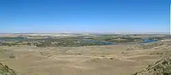 Missouri River below Fort Peck Dam | |
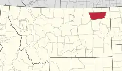 Location in Montana | |
| Tribe | Fort Peck Assiniboine and Sioux |
| Country | United States |
| State | Montana |
| Counties | Daniels Roosevelt Sheridan Valley |
| Established | 1878 |
| Headquarters | Poplar |
| Government | |
| • Body | Tribal Executive Board |
| • Chairman | Floyd Azure |
| • Vice-Chairman | Charles Headdress |
| Population (2017)[2] | |
| • Total | 10,374 |
| Time zone | UTC-7 (MST) |
| • Summer (DST) | UTC-6 (MDT) |
| Area code(s) | 406 |
| Website | fortpecktribes.org |
.jpg.webp)
With a total land area of 2,094,000 acres (8,470 km2; 3,272 sq mi),[3] it is the ninth-largest Indian reservation in the United States. These lands are spread across parts of four counties. In descending order of land area they are Roosevelt, Valley, Daniels, and Sheridan counties. Its resident population was 10,381 in 2000.[4] The largest community on the reservation is the city of Wolf Point.
In June 2015, the Department of Interior sent offers to buy back land worth $230 million to nearly 12,000 individual owners at the Fort Peck Indian Reservation and the smaller Fort Belknap Indian Reservation. This was under the Land Buy-Back Program for Tribal Nations, established as part of the federal government's settlement of the landmark Cobell v. Salazar suit over federal mismanagement of revenues due Indian landowners under the trust program.[5]
History
1850s - 1870s
The federal government established the Great Sioux Reservation under the Treaty of 1851, encompassing much of the area of West River in what is now South Dakota, as well as portions of North Dakota and Nebraska. As some bands of the Sioux agreed to come into agencies, others chose to resist. Army efforts to bring in the other Sioux (characterized as "hostiles") led to battles in the Rosebud country and culminated in the Battle of the Little Bighorn in 1876. The United States forces were roundly defeated there.
As the victors dispersed, Sitting Bull led followers north into the Red Water country. The Hunkpapa and assorted Teton peoples gained some supplies from contact with the Sioux at what was then known as the Fort Peck Agency. When military pressure increased in 1877, Sitting Bull led most of his followers over the border into Canada. The federal government increased its military forces in the area in an effort to induce Sitting Bull to surrender.
In 1878, the Fort Peck Indian Agency was relocated to its present-day location in Poplar, Montana, because the original agency was located on a flood plain, which flooded every spring. The current Camp Poplar (located at Fort Peck Agency) was established in 1880. That year, Presbyterian missionary Rev. G.W. Wood, Jr. came from Northern Michigan with his family to lead the Poplar Creek mission. Without supplies and barely tolerated by the First Nations peoples in the area of present-day southern Saskatchewan, who we're dealing with limited resources, Sitting Bull returned to the United States. He surrendered at Fort Buford on July 19, 1881. Some of his Hunkpapa stragglers intermarried with other Native Americans at Fort Peck and resided in the Chelsea community.
1880s and 1890s
By 1881, the wild American bison had been hunted to near-extinction by commercial hunters. By 1883/84, more than 300 Assiniboine died of starvation while forcibly incarcerated at the Wolf Point sub-agency. Rations were insufficient, and the suffering reservation-wide was exacerbated by particularly severe winters.
In 1884, Wolf Point was suffering from extreme poverty and starvation, so the Indian Rights Association convinced Congress to make a special appropriation for them.[6] In the spring of 1884, residents built a dam to enable irrigation. From 1885 to Montana Statehood in 1889, the tribes participated in agreements with the US government to re-drawing the Fort Peck reservation boundaries in exchange for federal subsidies.[7]
Also in 1887, Congress passed the Dawes Act, which provided the general legislation for dividing the allegedly tribally-owned Indian reservations into parcels of land under individual titles. Around the start of the 20th century, non-Indians continued to violate the Reservation boundary areas, then encroached into the prime grazing and farmland areas within the Reservation territories. As more and more homesteaders moved into the surrounding areas, pressure was placed on Congress to open up the Fort Peck Reservation to homesteading.
1900s and 1910s
On May 30, 1908, Fort Peck Allotment Act was passed by Congress. The Act called for the survey and allotment of lands now embraced by the Fort Peck Indian Reservation and the sale and dispersal of all the surplus lands after allotment. Each eligible Indian was to receive 320 acres (1.3 km2; 0.50 sq mi) of grazing land in addition to some timber and irrigable land. Parcels of land were also withheld for Agency, school, and church use. Land was also reserved for use by the Great Northern (Burlington Northern) Railroad. All lands not allotted or reserved were declared surplus and were ready to be disposed of under the homestead's general provisions, desert land, mineral, and townsite laws.
In 1913, approximately 1,348,408 acres (5,456.81 km2; 2,106.888 sq mi) of unallotted or tribal unreserved lands were available for settlement by the non-Indian homesteaders. Although provisions were made to sell the remaining land not disposed of in the first five years, it was never completed. Several additional allotments were made before the 1930s.
1920s to present
Educational history on the Reservation includes a government boarding school program that was begun in 1877 and finally discontinued in the 1920s. Missionary schools were run periodically by the Mormons and Presbyterians in the first decades of the 20th century, but with minimal success. The Fort Peck Reservation is served by five public school districts, which are responsible for elementary and secondary education. In addition, an independent post-secondary institution is located on the Reservation: Fort Peck Community College, which offers nine associate of arts, six associate of science, and ten associate of applied science degrees. In recent years, the quality of education delivered to the Reservation's children has become a matter of scrutiny.[8]
Fort Peck Reservation is home to two separate Indian nations, each composed of numerous bands and divisions. The Sioux divisions of Sisseton/Wahpetons, the Yanktonais, and the Teton Hunkpapa are all represented. The Assiniboine bands of Canoe Paddler and Red Bottom are represented. The Reservation is located in Montana's extreme northeast corner, on the north side of the Missouri River.
The Reservation is 110 miles (180 km) long and 40 miles (64 km) wide, encompassing 2,093,310 acres (8,471.3 km2; 3,270.80 sq mi). Of this, approximately 378,000 acres (1,530 km2; 591 sq mi) are tribally owned and 548,000 acres (2,220 km2; 856 sq mi) are individually allotted Indian lands. The total of Indian owned lands is about 926,000 acres (3,750 km2; 1,447 sq mi). There are an estimated 10,000 enrolled tribal members, of whom approximately 6,000 reside on or near the Reservation. The population density is greatest along the southern border of the Reservation near the Missouri River and the major transportation routes, U.S. Highway 2 and the Amtrak routing on the tracks of the Burlington Northern Railroad.
The Fort Peck Tribes adopted their first written constitution in 1927. The Tribes voted to reject a new constitution under the Indian Reorganization Act in 1934. The original constitution was amended in 1952 and completely rewritten and adopted in 1960. The present constitution remains one of the few modern tribal constitutions that still includes provisions for general councils, the traditional tribal type of government. The official governing body of the Fort Peck Tribes is the Tribal Executive Board, composed of twelve voting members, plus a chairman, vice-chairman, secretary-accountant, and sergeant-at-arms. All members of the governing body, except the secretary-accountant, are elected at large every two years.
Peoples and sovereignty
The Tribal Government has control over most activities inside of the reservation borders. The Tribe has its own court system, jail, and treatment center. In addition to the Tribal Government, there are also city and county governments, as well as a newly formed Sisseton Wahpeton Sioux Council.[9] The Tribal Headquarters are located in Poplar, widely viewed as the capital of the Reservation.[10] The Bureau of Indian Affairs has the Fort Peck Agency located in Poplar.
The reservation is home to The Assiniboine and Sioux Tribes (Assiniboine: įhą́ktuwąna[11]). Though separate, both tribes have similar-sounding languages and are of the Siouan language family. The Fort Peck Tribes have an estimated 11,000 enrolled members, half of which reside on the reservation. Many "associate members" mean they have Indian blood but not enough to be enrolled with the tribe. To be enrolled, or recognized as an official tribal member, a person must be at least 1/4 Fort Peck Indian blood. This is done through blood quantum measurements kept by the tribe.
The Fort Peck Tribes is the largest employer on the reservation and in the region with over 350 employees.
Big-game hunting on the reservation is limited to enrolled tribal members only. Upland bird seasons are open to the general public.
Bison
In March 2012, 63 American bison from Yellowstone National Park were transferred to the Fort Peck Indian Reservation prairie, to be released to a 2,100-acre (8.5 km2; 3.3 sq mi) game preserve 25 miles (40 km) north of Poplar. There are many other bison herds outside Yellowstone, but this is one of the very few genetically pure ones, not cross-bred with cattle. Native Americans celebrated the move, which came over a century after bison were nearly wiped out by hunters and the government. The Assiniboine and Gros Ventre tribes at the Fort Belknap Indian Reservation will also receive a portion of this herd.[12] In November 2014, an additional 136 American Bison from Yellowstone National Park were added to the Fort Peck Herd. The preserve has also been enlarged to 13,000 acres (53 km2; 20 sq mi) as Fort Peck Fish and Game works toward their target goal of 1,000 bison, which scientists feel is the minimum herd size necessary to restore the Bison to the role they once had in the environment.[13] The tribe continues to receive Yellowstone bison for quarantine and transfer to other tribes.[14][15]
Notable tribal members
- Dolly Akers, legislator
- David Midthunder, Actor
- Amber Midthunder, actress
- Chaske Spencer
- Minnie Two Shoes (1950–2010), journalist, activist, co-founder of the Native American Press Association
- Frank W. Warner
- Horse's Ghost
References
- "Fort Peck Tribes - Chairman". Retrieved 2019-07-24.
- 2013-2017 American Community Survey 5-Year Estimates. "My Tribal Area". United States Census Bureau.
- "Fort Peck Agency". Fort Peck Agency. Department of the Interior, Bureau if Indian Affairs. Retrieved 2016-02-17.
- "Profile of General Demographic Characteristics: 2000 Geographic Area: Fort Peck Reservation and Off-Reservation Trust Land, MT" (PDF). United States Census Bureau. United States Census Bureau. Archived from the original (PDF) on 2016-10-11. Retrieved 2016-02-17.
- "DOI sends over $230M in offers to Indian landowners in Montana", Indianz.com, 8 June 2015; accessed 28 October 2016
- "Report of the Board of Indian Commissioners, 1885". University of Oklahoma College of Law. H.R. Exec. Doc. No. 1, 49th Cong., 1st Sess. (1885). pp. 806–807. Retrieved 10 July 2020.
"When the meager crops which they bad obtained from the. soil were exhausted," says Mr. Wood, "they ate their dogs and some of their horses. Meanwhile, in the spring of 1884, Congress made a special appropriation for the relief of the Indian in this Territory, for which, I understand, we are indebted to the Indian Rights Association. In the summer the Indians built a dam on Wolf Creek, and dug ditches for the purpose of irrigation, but were too late to secure a crop for their first season".
- Shanley, James; Smith, Dennis; McGeshick, Joseph R.; Miller, David Reed (2008). The History of the Assiniboine and Sioux Tribes of the Fort Peck Indian Reservation, Montana, 1800–2000. Poplar, MT: Fort Peck Community College. p. 497. ISBN 978-0-9759196-5-1. Retrieved February 21, 2017.
- Annie Waldman, Erica L. Green (28 Dec 2018). "District of Despair: On a Montana Reservation, Schools Favor Whites Over Native Americans". ProPublica. Retrieved 31 December 2018.
- Lance Four Star (2006-07-20). "Chairman Rights A Wrong For Sisseton Wahpeton Sioux". Montana Memory. Wotin Wowapi. Retrieved 2016-02-19.
- "Fort Peck Tribes". Fort Peck Tribes Official Site. Retrieved 2016-02-17.
- "AISRI Dictionary Database Search--prototype version. Assiniboine. "Montana"". Retrieved 2012-07-07.
- "Yellowstone bison return to tribal land". Great Falls Tribune. 2012-03-21. Retrieved 2012-03-23.
- "Fort Peck Tribes Leaders Restore Bison on Reservation". World Wildlife Fund. 2014-12-23. Retrieved 2016-11-01.
- Maher, Savannah (August 25, 2020). "Fort Peck Tribes Carry Out Largest Ever Inter-Tribal Buffalo Transfer". Wyoming Public Radio. NPR News. Retrieved 2020-08-26.
- French, Brett (September 2, 2020). "3 Yellowstone bison begin long journey to Alaskan island". The Billings Gazette. Retrieved 2020-09-03.
External links
- Fort Peck Reservation and Off-Reservation Trust Land, Montana United States Census Bureau
- http://www.fortpecktribes.org/
1 No reservation in state, trust lands or legal status only |
| Authority control |
|---|