Freeport, Minnesota
Freeport is a city in Stearns County, Minnesota, United States. The population was 632 at the 2010 census.[6] Freeport is part of the St. Cloud Metropolitan Statistical Area.
Freeport | |
|---|---|
| Motto(s): The city with a smile | |
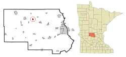 Location of Freeport within Stearns County, Minnesota | |
| Coordinates: 45°40′N 94°41′W | |
| Country | United States |
| State | Minnesota |
| County | Stearns |
| Government | |
| • Mayor | Mike Eveslage |
| Area | |
| • Total | 1.19 sq mi (3.09 km2) |
| • Land | 1.19 sq mi (3.08 km2) |
| • Water | 0.01 sq mi (0.01 km2) |
| Elevation | 1,243 ft (379 m) |
| Population | |
| • Total | 632 |
| • Estimate (2019)[3] | 669 |
| • Density | 562.66/sq mi (217.31/km2) |
| Time zone | UTC-6 (Central (CST)) |
| • Summer (DST) | UTC-5 (CDT) |
| ZIP code | 56331 |
| Area code(s) | 320 |
| FIPS code | 27-22652[4] |
| GNIS feature ID | 0643925[5] |
| Website | www.freeportmn.org |

History
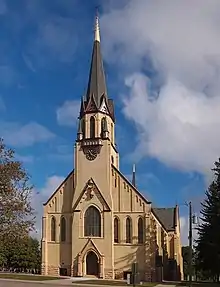
A post office called Freeport has been in operation since 1881.[7] The city was named after Freeport, Illinois.[8] Freeport was incorporated in 1892.[8] The city contains two properties listed on the National Register of Historic Places: the 1905 Church of the Sacred Heart and remnants of the 1898 Swany White Flour Mills.[9]
Geography
According to the United States Census Bureau, the city has a total area of 1.15 square miles (2.98 km2), all land.[10]
The city of Freeport is located within Oak Township geographically but is a separate entity.
Freeport is located along Interstate 94/U.S. Highway 52. Other routes include Stearns County Roads 11 and 157. Getchell Creek flows nearby.
Demographics
| Historical population | |||
|---|---|---|---|
| Census | Pop. | %± | |
| 1900 | 313 | — | |
| 1910 | 450 | 43.8% | |
| 1920 | 525 | 16.7% | |
| 1930 | 456 | −13.1% | |
| 1940 | 548 | 20.2% | |
| 1950 | 558 | 1.8% | |
| 1960 | 615 | 10.2% | |
| 1970 | 593 | −3.6% | |
| 1980 | 563 | −5.1% | |
| 1990 | 556 | −1.2% | |
| 2000 | 454 | −18.3% | |
| 2010 | 632 | 39.2% | |
| 2019 (est.) | 669 | [3] | 5.9% |
| U.S. Decennial Census[11] | |||
2010 census
As of the census[2] of 2010, there were 632 people, 271 households, and 184 families living in the city. The population density was 549.6 inhabitants per square mile (212.2/km2). There were 280 housing units at an average density of 243.5 per square mile (94.0/km2). The racial makeup of the city was 97.0% White, 0.3% Native American, 0.2% Asian, and 2.5% from other races. Hispanic or Latino of any race were 4.6% of the population.
There were 271 households, of which 26.2% had children under the age of 18 living with them, 59.4% were married couples living together, 5.2% had a female householder with no husband present, 3.3% had a male householder with no wife present, and 32.1% were non-families. 26.2% of all households were made up of individuals, and 15.8% had someone living alone who was 65 years of age or older. The average household size was 2.33 and the average family size was 2.76.
The median age in the city was 37 years. 18.2% of residents were under the age of 18; 8.4% were between the ages of 18 and 24; 29.1% were from 25 to 44; 24.7% were from 45 to 64; and 19.6% were 65 years of age or older. The gender makeup of the city was 50.8% male and 49.2% female.
2000 census
As of the census[4] of 2000, there were 454 people, 190 households, and 132 families living in the city. The population density was 514.3 people per square mile (199.2/km2). There were 199 housing units at an average density of 225.4 per square mile (87.3/km2). The racial makeup of the city was 99.34% White, 0.22% from other races, and 0.44% from two or more races. Hispanic or Latino of any race were 0.88% of the population.
There were 190 households, out of which 26.8% had children under the age of 18 living with them, 60.0% were married couples living together, 5.8% had a female householder with no husband present, and 30.5% were non-families. 27.4% of all households were made up of individuals, and 21.1% had someone living alone who was 65 years of age or older. The average household size was 2.39 and the average family size was 2.88.
In the city, the population was spread out, with 24.7% under the age of 18, 7.9% from 18 to 24, 23.1% from 25 to 44, 19.6% from 45 to 64, and 24.7% who were 65 years of age or older. The median age was 41 years. For every 100 females, there were 94.8 males. For every 100 females age 18 and over, there were 83.9 males.
The median income for a household in the city was $32,955, and the median income for a family was $39,063. Males had a median income of $31,964 versus $22,125 for females. The per capita income for the city was $15,827. About 3.2% of families and 7.9% of the population were below the poverty line, including 6.3% of those under age 18 and 14.3% of those age 65 or over.
In the media
Garrison Keillor, creator of Lake Wobegon and host of the radio variety show A Prairie Home Companion, has written that Stearns County in general and Freeport specifically, in addition to other small Minnesota towns, were inspirations for his fictional town, Lake Wobegon. In 1998, the county honored Keillor and his show by naming a section of abandoned rail line the Lake Wobegon Trail.[12]
Notable person
Janice Ettle, two-time winner of Grandma's Marathon and winner of the 1985 Twin Cities Marathon, grew up on a farm near Freeport. She finished 14th at the 1987 World Marathon Cup and competed in the 1991 Pan American Games women's marathon. She is one of a small number of women to have competed in five United States Olympic marathon trials. In the 1984 race (the first ever, for the first woman's Olympic marathon race), she finished sixth.[13]
References
- "2019 U.S. Gazetteer Files". United States Census Bureau. Retrieved July 26, 2020.
- "American FactFinder". United States Census Bureau. Archived from the original on 2020-02-12. Retrieved 2012-11-13.
- "Population and Housing Unit Estimates". United States Census Bureau. May 24, 2020. Retrieved May 27, 2020.
- "American FactFinder". United States Census Bureau. Archived from the original on 2020-02-12. Retrieved 2008-01-31.
- "US Board on Geographic Names". United States Geological Survey. 2007-10-25. Retrieved 2008-01-31.
- "2010 Census Redistricting Data (Public Law 94-171) Summary File". American FactFinder. U.S. Census Bureau, 2010 Census. Retrieved 23 April 2011.
- "Stearns County". Jim Forte Postal History. Archived from the original on 18 January 2016. Retrieved 8 August 2015.
- Upham, Warren (1920). Minnesota Geographic Names: Their Origin and Historic Significance. Minnesota Historical Society. p. 524.
- "Minnesota National Register Properties Database". Minnesota Historical Society. 2009. Retrieved 2018-06-12.
- "US Gazetteer files 2010". United States Census Bureau. Archived from the original on 2012-07-02. Retrieved 2012-11-13.
- "Census of Population and Housing". Census.gov. Archived from the original on April 26, 2015. Retrieved June 4, 2015.
- In Search of Lake Wobegon (National Geographic Magazine); Garrison Keillor; December 2000
- Rajkowski, Frank (14 June 2014). "Looking Back: 1989 Grandma's Marathon just one of many memorable races for Ettle". St. Cloud Times. Retrieved 4 May 2020.
External links
Municipalities and communities of Stearns County, Minnesota, United States | ||
|---|---|---|
| Cities |
|  Map of Minnesota highlighting Stearns County |
| Townships |
| |
| CDP | ||
| Unincorporated communities | ||
| Ghost towns/Neighborhoods | ||
| Footnotes | ‡This populated place also has portions in an adjacent county or counties | |
| ||
| Core City |  | ||||
|---|---|---|---|---|---|
| Surrounding communities |
| ||||
| Counties | |||||
‡ indicates that it is partially in the metropolitan area. § indicates a CDP | |||||
| Authority control |
|---|