Rockville, Minnesota
Rockville is a city in Stearns County, Minnesota, United States. The population was 2,448 as of the 2010 census.[7] It is part of the St. Cloud Metropolitan Statistical Area.
Rockville | |
|---|---|
 | |
| Motto(s): "Granite-Heart Of The City"[1] | |
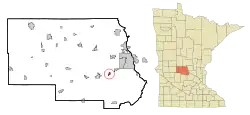 Location of Rockville within Stearns County, Minnesota | |
| Coordinates: 45°28′21″N 94°20′24″W | |
| Country | United States |
| State | Minnesota |
| County | Stearns |
| Area | |
| • Total | 30.43 sq mi (78.82 km2) |
| • Land | 28.68 sq mi (74.29 km2) |
| • Water | 1.75 sq mi (4.53 km2) |
| Elevation | 1,076 ft (328 m) |
| Population | |
| • Total | 2,448 |
| • Estimate (2019)[4] | 2,585 |
| • Density | 90.13/sq mi (34.80/km2) |
| Time zone | UTC-6 (Central (CST)) |
| • Summer (DST) | UTC-5 (CDT) |
| ZIP code | 56369 |
| Area code(s) | 320 |
| FIPS code | 27-55078[5] |
| GNIS feature ID | 0650208[6] |
| Website | www.rockvillecity.org |
History
Rockville was platted in 1856, and named for granite rock formations on nearby streams.[8] A post office has been in operation at Rockville since 1857. Levi Gaylord was selected as the first Postmaster. The Government selected Newton Smith on June 6, 1861.[9] In Rockville the Clark and McCormack Quarry and House, consisting of a quarry established in 1907 and a house built in 1924, is listed on the National Register of Historic Places.[10]
On June 1, 2002, the city of Pleasant Lake and Rockville Township were merged into the city of Rockville.[11]
Geography
According to the United States Census Bureau, the city has a total area of 30.17 square miles (78.14 km2); 28.42 square miles (73.61 km2) is land and 1.75 square miles (4.53 km2) is water.[12]
Rockville, including the former Rockville Township, is located in Township 123 North of the Arkansas Base Line and Range 29 West of the Fifth Principal Meridian.
Demographics
| Historical population | |||
|---|---|---|---|
| Census | Pop. | %± | |
| 1910 | 127 | — | |
| 1920 | 172 | 35.4% | |
| 1930 | 294 | 70.9% | |
| 1940 | 345 | 17.3% | |
| 1950 | 288 | −16.5% | |
| 1960 | 357 | 24.0% | |
| 1970 | 302 | −15.4% | |
| 1980 | 597 | 97.7% | |
| 1990 | 579 | −3.0% | |
| 2000 | 749 | 29.4% | |
| 2010 | 2,448 | 226.8% | |
| 2019 (est.) | 2,585 | [4] | 5.6% |
| U.S. Decennial Census[13] | |||
2010 census
As of the census[3] of 2010, there were 2,448 people, 880 households, and 703 families living in the city. The population density was 86.1 inhabitants per square mile (33.2/km2). There were 1,041 housing units at an average density of 36.6 per square mile (14.1/km2). The racial makeup of the city was 91.9% White, 0.3% African American, 0.2% Native American, 0.2% Asian, 0.5% Pacific Islander, 6.1% from other races, and 0.8% from two or more races. Hispanic or Latino of any race were 9.3% of the population.
There were 880 households, of which 37.0% had children under the age of 18 living with them, 68.8% were married couples living together, 6.5% had a female householder with no husband present, 4.7% had a male householder with no wife present, and 20.1% were non-families. 14.4% of all households were made up of individuals, and 4.8% had someone living alone who was 65 years of age or older. The average household size was 2.78 and the average family size was 3.04.
The median age in the city was 40.5 years. 25.8% of residents were under the age of 18; 8.2% were between the ages of 18 and 24; 23.5% were from 25 to 44; 31.1% were from 45 to 64; and 11.4% were 65 years of age or older. The gender makeup of the city was 51.9% male and 48.1% female.
2000 census
As of the census[5] of 2000, there were 749 people, 268 households, and 187 families living in the city. The population density was 1,140.7 people per square mile (438.2/km2). There were 281 housing units at an average density of 427.9 per square mile (164.4/km2). The racial makeup of the city was 94.53% White, 1.34% African American, 0.13% Native American, 3.20% from other races, and 0.80% from two or more races. Hispanic or Latino of any race were 6.54% of the population.
There were 268 households, out of which 44.8% had children under the age of 18 living with them, 58.2% were married couples living together, 7.1% had a female householder with no husband present, and 30.2% were non-families. 23.1% of all households were made up of individuals, and 6.3% had someone living alone who was 65 years of age or older. The average household size was 2.79 and the average family size was 3.33.
In the city, the population was spread out, with 31.5% under the age of 18, 11.1% from 18 to 24, 37.0% from 25 to 44, 13.9% from 45 to 64, and 6.5% who were 65 years of age or older. The median age was 29 years. For every 100 females, there were 106.3 males. For every 100 females age 18 and over, there were 113.8 males.
The median income for a household in the city was $43,854, and the median income for a family was $50,083. Males had a median income of $31,964 versus $22,000 for females. The per capita income for the city was $16,527. About 2.1% of families and 4.8% of the population were below the poverty line, including 3.0% of those under age 18 and none of those age 65 or over.
Infrastructure
Transportation
Minnesota State Highway 23 serves as a main route in the city, and Interstate 94 passes nearby.
References
- "City of Rockville Minnesota". City of Rockville Minnesota. Retrieved October 9, 2012.
- "2019 U.S. Gazetteer Files". United States Census Bureau. Retrieved July 26, 2020.
- "U.S. Census website". United States Census Bureau. Retrieved 2012-11-13.
- "Population and Housing Unit Estimates". United States Census Bureau. May 24, 2020. Retrieved May 27, 2020.
- "U.S. Census website". United States Census Bureau. Retrieved 2008-01-31.
- "US Board on Geographic Names". United States Geological Survey. 2007-10-25. Retrieved 2008-01-31.
- "2010 Census Redistricting Data (Public Law 94-171) Summary File". American FactFinder. U.S. Census Bureau, 2010 Census. Retrieved 23 April 2011.
- Upham, Warren (1920). Minnesota Geographic Names: Their Origin and Historic Significance. Minnesota Historical Society. p. 526.
- "Stearns County". Jim Forte Postal History. Retrieved 8 August 2015.
- "Minnesota National Register Properties Database". Minnesota Historical Society. 2009. Retrieved 2018-06-12.
- Population Estimates Geographic Change Notes: Minnesota Archived 2008-05-02 at the Wayback Machine, 2006-05-19. Accessed 2008-05-28.
- "US Gazetteer files 2010". United States Census Bureau. Archived from the original on 2012-07-02. Retrieved 2012-11-13.
- "Census of Population and Housing". Census.gov. Retrieved June 4, 2015.
External links
Municipalities and communities of Stearns County, Minnesota, United States | ||
|---|---|---|
| Cities |
|  Map of Minnesota highlighting Stearns County |
| Townships |
| |
| CDP | ||
| Unincorporated communities | ||
| Ghost towns/Neighborhoods | ||
| Footnotes | ‡This populated place also has portions in an adjacent county or counties | |
| ||
| Core City |  | ||||
|---|---|---|---|---|---|
| Surrounding communities |
| ||||
| Counties | |||||
‡ indicates that it is partially in the metropolitan area. § indicates a CDP | |||||