Stearns County, Minnesota
Stearns County is a county in the U.S. state of Minnesota. As of the 2010 United States Census, the population was 150,642.[1] Its county seat is St. Cloud.[2] The county was founded in 1855. It was originally named for Isaac Ingalls Stevens, then renamed for Charles Thomas Stearns.
Stearns County | |
|---|---|
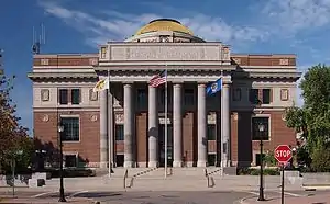 Stearns County Courthouse | |
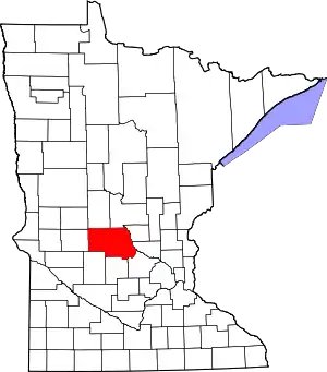 Location within the U.S. state of Minnesota | |
 Minnesota's location within the U.S. | |
| Coordinates: 45°33′N 94°37′W | |
| Country | |
| State | |
| Founded | February 20 |
| Named for | Charles Thomas Stearns |
| Seat | St. Cloud |
| Largest city | St. Cloud |
| Area | |
| • Total | 1,390 sq mi (3,600 km2) |
| • Land | 1,343 sq mi (3,480 km2) |
| • Water | 47 sq mi (120 km2) 3.4%% |
| Population (2010) | |
| • Total | 150,642 |
| • Estimate (2019) | 161,075 |
| • Density | 118.6/sq mi (45.8/km2) |
| Time zone | UTC−6 (Central) |
| • Summer (DST) | UTC−5 (CDT) |
| Congressional districts | 6th, 7th |
| Website | www |
Stearns County is part of the St. Cloud Metropolitan Statistical Area, which is also included in the Minneapolis-St. Paul Combined Statistical Area.
History
The Stearns County area was formerly occupied by numerous indigenous tribes, such as the Sioux (Dakota), Chippewa (Ojibwe) and Winnebago (Ho-chunk). The first large immigration was of German Catholics in the 1850s. Early arrivals also came from eastern states. The Wisconsin Territory was established by the federal government effective July 3, 1836, and existed until its eastern portion was granted statehood (as Wisconsin) in 1848. The federal government set up the Minnesota Territory effective March 3, 1849. The newly organized territorial legislature created nine counties across the territory in October of that year. The original counties had portions partitioned off in 1851 to create Cass County and in 1853 to create Sibley, Pierce, and Nicollet counties. In 1855 parts of those counties were partitioned off to create Stearns County. It was to be named Stevens County for territorial governor Isaac Ingalls Stevens, who had conducted an expedition through the area in 1853. But due to a clerical error, the county was named Stearns for Charles Thomas Stearns, a member of the Territorial Council. (To compensate for this error the area two counties west was later named Stevens County.) The February 20, 1855 act[3] that created the county directed the naming of three county commissioners and specified St. Cloud as the county seat. The first courthouse was put into service on 12 July 1864, and it remained in use until the present courthouse was dedicated in 1922. In 1913 a campaign was mounted to shift the county seat to Albany, due to its more central location. The effort was not successful.[4]
Geography
Stearns County abuts nine counties; no Minnesota county touches a greater number. The Mississippi River flows southeast along its northeast border, and the Sauk River drains the central part of the county into the Mississippi at St. Cloud. The county terrain consists of low rolling hills, lightly wooded, dotted with lakes and ponds, and carved with drainages. All available area is devoted to agriculture or has been developed.[6] The terrain slopes to the east and south,[7] with its highest point a local protuberance at 7.6 miles (12.2 km) west and 1.6 mile (2.6 km) south of St. Joseph, at 1,461' (445m) ASL.[8] The county's total area is 1,390 square miles (3,600 km2), of which 1,343 square miles (3,480 km2) is land and 47 square miles (120 km2) (3.4%) is water.[9]
The northeastern border of Stearns County is formed by the Mississippi River. The land consists of rolling hills, scenic lakes, prairies, savannas and woodlands of a mixture of coniferous and deciduous trees. Stearns is one of 17 Minnesota savanna region counties with more savanna soils than either prairie or forest soils. The county has 166 lakes.
Major highways
 Interstate 94
 U.S. Highway 52
 U.S. Highway 71
 Minnesota State Highway 4
 Minnesota State Highway 15
 Minnesota State Highway 22
 Minnesota State Highway 23
 Minnesota State Highway 24
 Minnesota State Highway 28
 Minnesota State Highway 55
 Minnesota State Highway 237
 Minnesota State Highway 238
- List of county roads
Airports[6]
- Brooten Municipal Airport (6D1) - east of Brooten
- Paynesville Municipal Airport (PEX) - west of Paynesville
- Sauk Centre Municipal Airport (D39) - south-southeast of Sauk Centre
- St. Cloud Regional Airport (STC) - northeast of St. Cloud
Adjacent counties
- Todd County - north
- Morrison County - northeast
- Benton County - northeast
- Sherburne County - east
- Wright County - southeast
- Meeker County - south
- Kandiyohi County - southwest
- Pope County - west
- Douglas County - northwest
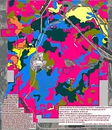
Protected areas[6][7]
- Aron Hills Forest Scientific and Natural Area
- Birch Lakes State Forest
- Christopher Kurilla Wildlife Management Area
- Cold Spring Heron Colony Scientific and Natural Area
- Crow River Wildlife Management Area
- Edward Raymond Mohs Wildlife Management Area
- Follies Wildlife Management Area (part)
- Lake Koronis Regional Park
- Legacy Marsh Wildlife Management Area
- Miller Wildlife Management Area
- Milton Kjedahl Wildlife Management Area
- Norman T. Dahlman Wildlife Management Area
- Oxcart Crossing Wildlife Management Area
- Padua State Wildlife Management Area
- Patch Woods Scientific and Natural Area
- Quarry Park and Nature Preserve
- Quarry Park Scientific and Natural Area
- Rockville County Park and Nature Preserve
- Roscoe Prairie Scientific and Natural Area
- Saint Wendel Tamarack Bog Scientific and Natural Area
- Sauk River Wildlife Management Area
- Sedan Brook Prairie Scientific and Natural Area
- Stearns Prairie Heritage Wildlife Management Area
- Tamarack State Wildlife Management Area
- Tower State Wildlife Management Area
- Tribute Wildlife Management Area
- Victor Winder Wildlife Management Area
- Warner Lake County Park
- Zion State Wildlife Management Area
Demographics
| Historical population | |||
|---|---|---|---|
| Census | Pop. | %± | |
| 1860 | 4,505 | — | |
| 1870 | 14,206 | 215.3% | |
| 1880 | 21,956 | 54.6% | |
| 1890 | 34,844 | 58.7% | |
| 1900 | 44,464 | 27.6% | |
| 1910 | 47,733 | 7.4% | |
| 1920 | 55,741 | 16.8% | |
| 1930 | 62,121 | 11.4% | |
| 1940 | 67,200 | 8.2% | |
| 1950 | 70,681 | 5.2% | |
| 1960 | 80,345 | 13.7% | |
| 1970 | 95,400 | 18.7% | |
| 1980 | 108,161 | 13.4% | |
| 1990 | 118,791 | 9.8% | |
| 2000 | 133,166 | 12.1% | |
| 2010 | 150,642 | 13.1% | |
| 2019 (est.) | 161,075 | [10] | 6.9% |
| US Decennial Census[11] 1790-1960[12] 1900-1990[13] 1990-2000[14] 2010-2019[1] | |||
2000 census
As of the 2000 United States Census, there were 133,166 people, 47,604 households, and 32,132 families in the county. The population density was 99.2/sqmi (38.3/km2). There were 50,291 housing units at an average density of 37.4/sqmi (14.5/km2). The racial makeup of the county was 95.99% White, 0.83% Black or African American, 0.26% Native American, 1.58% Asian, 0.03% Pacific Islander, 0.47% from other races, and 0.82% from two or more races. 1.37% of the population were Hispanic or Latino of any race. 56.9% were of German and 9.4% Norwegian ancestry.
There were 47,604 households, out of which 35.00% had children under the age of 18 living with them, 56.30% were married couples living together, 7.50% had a female householder with no husband present, and 32.50% were non-families. 23.60% of all households were made up of individuals, and 8.40% had someone living alone who was 65 years of age or older. The average household size was 2.64 and the average family size was 3.15.
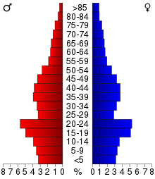
The county population contained 25.70% under the age of 18, 16.10% from 18 to 24, 28.00% from 25 to 44, 19.10% from 45 to 64, and 11.00% who were 65 years of age or older. The median age was 32 years. For every 100 females, there were 101.20 males. For every 100 females age 18 and over, there were 99.80 males.
The median income for a household in the county was $42,426, and the median income for a family was $51,553. Males had a median income of $34,268 versus $23,393 for females. The per capita income for the county was $19,211. About 4.30% of families and 8.70% of the population were below the poverty line, including 6.70% of those under age 18 and 8.60% of those age 65 or over.
Communities
Cities
- Albany
- Avon
- Belgrade
- Brooten (part)
- Clearwater (part)
- Cold Spring
- Eden Valley (part)
- Elrosa
- Freeport
- Greenwald
- Holdingford
- Kimball
- Lake Henry
- Meire Grove
- Melrose
- New Munich
- Paynesville
- Richmond
- Rockville
- Roscoe
- Saint Anthony
- Saint Augusta
- Saint Cloud (county seat; partial)
- Saint Joseph
- Saint Martin
- Saint Rosa
- Saint Stephen
- Sartell (part)
- Sauk Centre
- Spring Hill
- Waite Park
Census-designated place
Unincorporated communities
Townships
- Albany Township
- Ashley Township
- Avon Township
- Brockway Township
- Collegeville Township
- Crow Lake Township
- Crow River Township
- Eden Lake Township
- Fair Haven Township
- Farming Township
- Getty Township
- Grove Township
- Holding Township
- Krain Township
- Lake George Township
- Lake Henry Township
- Le Sauk Township
- Luxemburg Township
- Lynden Township
- Maine Prairie Township
- Melrose Township
- Millwood Township
- Munson Township
- North Fork Township
- Oak Township
- Paynesville Township
- Raymond Township
- Saint Joseph Township
- Saint Martin Township
- Saint Wendel Township
- Sauk Centre Township
- Spring Hill Township
- Wakefield Township
- Zion Township
Politics and government
In its early history Stearns County was heavily Democratic due to being largely German Catholic and opposed to the pietistic Scandinavian Lutheran Republican Party of that era. It did not vote Republican until Theodore Roosevelt swept every Minnesota county in 1904.[15] Anti-Woodrow Wilson feeling from World War I caused the county to shift overwhelmingly to Warren G. Harding in 1920 before swinging to Robert M. La Follette, coreligionist Al Smith and fellow “wet” Democrat Franklin D. Roosevelt.
In 1936 the county's isolationism gave strong support to William Lemke’s Union Party.[16] Stearns County turned Republican until another Catholic nominee, John F. Kennedy, returned it to the Democratic ranks sufficiently to be one of only 130 counties nationwide to back George McGovern in 1972. Since the “Reagan Revolution”, Stearns County has voted reliably Republican, with no Democrat gaining a majority since Jimmy Carter in 1976, and Bill Clinton in 1996 the only one to manage a plurality. The county's growing social conservative bent has fueled the Republican trend.
In 2016 Donald Trump won the county with 59.8% of the vote, the highest percentage any presidential candidate has received since President Eisenhower in 1956. He improved on that in 2020 with 60.3% of the vote.
As of 2020, two cities in the county lean Democratic: St. Cloud, the largest city, and neighboring Waite Park.[17]
| Year | Republican | Democratic | Third parties |
|---|---|---|---|
| 2020 | 60.1% 50,959 | 37.6% 31,879 | 2.4% 1,997 |
| 2016 | 59.8% 47,617 | 32.1% 25,576 | 8.0% 6,399 |
| 2012 | 54.8% 43,015 | 42.8% 33,551 | 2.4% 1,911 |
| 2008 | 52.3% 41,194 | 45.3% 35,690 | 2.4% 1,872 |
| 2004 | 55.2% 41,726 | 43.2% 32,659 | 1.6% 1,192 |
| 2000 | 51.9% 32,402 | 39.7% 24,800 | 8.4% 5,274 |
| 1996 | 39.0% 21,474 | 44.0% 24,238 | 17.0% 9,333 |
| 1992 | 37.9% 22,502 | 36.2% 21,451 | 25.9% 15,387 |
| 1988 | 52.9% 27,529 | 45.7% 23,798 | 1.5% 766 |
| 1984 | 58.5% 30,216 | 40.6% 20,944 | 0.9% 485 |
| 1980 | 48.3% 24,888 | 42.4% 21,862 | 9.3% 4,772 |
| 1976 | 40.9% 19,574 | 52.3% 25,027 | 6.7% 3,220 |
| 1972 | 45.8% 18,951 | 46.7% 19,315 | 7.6% 3,134 |
| 1968 | 45.9% 15,422 | 47.6% 15,990 | 6.5% 2,168 |
| 1964 | 40.4% 13,009 | 59.3% 19,063 | 0.3% 94 |
| 1960 | 41.5% 13,522 | 58.4% 19,026 | 0.1% 33 |
| 1956 | 63.7% 17,364 | 36.1% 9,829 | 0.2% 64 |
| 1952 | 64.8% 18,267 | 35.1% 9,907 | 0.1% 39 |
| 1948 | 39.5% 10,153 | 59.4% 15,261 | 1.1% 292 |
| 1944 | 60.4% 13,298 | 39.3% 8,647 | 0.4% 84 |
| 1940 | 63.0% 16,027 | 36.6% 9,305 | 0.4% 102 |
| 1936 | 23.3% 5,262 | 56.5% 12,760 | 20.2% 4,558 |
| 1932 | 19.5% 4,499 | 79.4% 18,293 | 1.1% 258 |
| 1928 | 28.6% 6,459 | 71.2% 16,104 | 0.2% 52 |
| 1924 | 37.4% 6,469 | 7.8% 1,354 | 54.8% 9,491 |
| 1920 | 86.3% 13,566 | 10.3% 1,616 | 3.4% 532 |
| 1916 | 54.4% 4,312 | 42.3% 3,350 | 3.3% 259 |
| 1912 | 17.6% 1,134 | 51.6% 3,317 | 30.8% 1,983 |
| 1908 | 38.8% 2,614 | 56.9% 3,835 | 4.4% 296 |
| 1904 | 50.4% 2,849 | 46.5% 2,625 | 3.1% 175 |
| 1900 | 35.6% 2,460 | 61.3% 4,244 | 3.1% 216 |
| 1896 | 36.1% 2,873 | 61.6% 4,911 | 2.3% 183 |
| 1892 | 23.7% 1,624 | 65.0% 4,461 | 11.3% 774 |
See also
References
- "State & County QuickFacts". United States Census Bureau. Retrieved September 1, 2013.
- "Find a County". National Association of Counties. Retrieved June 7, 2011.
- "Minnesota Place Names". Minnesota Historical Society. Archived from the original on June 20, 2012. Retrieved March 19, 2014.
- History of Stearns County (from county website; accessed May 3, 2019)
- Nelson, Steven (2011). Savanna Soils of Minnesota. Minnesota: Self. pp. 49-52. ISBN 978-0-615-50320-2.
- Stearns County MN Google Maps (accessed 3 May 2019)
- "Find an Altitude/Stearns County MN" Google Maps (accessed 3 May 2019)
- Stearns County High Point, Minnesota. PeakBaggers.com (accessed 3 May 2019)
- "2010 Census Gazetteer Files". US Census Bureau. August 22, 2012. Archived from the original on September 21, 2013. Retrieved October 25, 2014.
- "Population and Housing Unit Estimates". Retrieved May 21, 2020.
- "US Decennial Census". US Census Bureau. Retrieved October 25, 2014.
- "Historical Census Browser". University of Virginia Library. Retrieved October 25, 2014.
- "Population of Counties by Decennial Census: 1900 to 1990". US Census Bureau. Retrieved October 25, 2014.
- "Census 2000 PHC-T-4. Ranking Tables for Counties: 1990 and 2000" (PDF). US Census Bureau. Retrieved October 25, 2014.
- Menendez, Albert J.; The Geography of Presidential Elections in the United States, 1868-2004, pp. 228-233 ISBN 0786422173
- Phillips, Kevin P.; The Emerging Republican Majority, pp. 428-430 ISBN 978-0-691-16324-6
- Leip, David. "Atlas of US Presidential Elections". uselectionatlas.org. Retrieved October 10, 2018.
- Leip, David. "Atlas of US Presidential Elections". uselectionatlas.org. Retrieved October 10, 2018.
Further reading
External links
- Stearns County official website
- Sartell Historical Society - Sartell, MN
- Stearns History Museum official website
Places adjacent to Stearns County, Minnesota | ||||||||||
|---|---|---|---|---|---|---|---|---|---|---|
| ||||||||||
Municipalities and communities of Stearns County, Minnesota, United States | ||
|---|---|---|
| Cities |
| Map of Minnesota highlighting Stearns County |
| Townships |
| |
| CDP | ||
| Unincorporated communities | ||
| Ghost towns/Neighborhoods | ||
| Footnotes | ‡This populated place also has portions in an adjacent county or counties | |
| ||
| Core City | 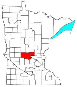 | ||||
|---|---|---|---|---|---|
| Surrounding communities |
| ||||
| Counties | |||||
‡ indicates that it is partially in the metropolitan area. § indicates a CDP | |||||

| Authority control |
|---|