St. Augusta, Minnesota
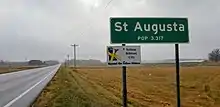
Saint Augusta, formerly named Ventura, is a city in Stearns County, Minnesota, United States, directly south of the city of St. Cloud. The population was 3,317 at the 2010 census and has increased to 3,835 according to 2019 estimates.[5]
- For the saint with this name, see Augusta of Treviso.
Saint Augusta | |
|---|---|
City | |
| Motto(s): "Where Country Meets Community" | |
 Saint Augusta | |
| Coordinates: 45°28′N 94°12′W | |
| Country | United States |
| State | Minnesota |
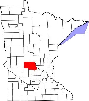
| County | Stearns |
| Area | |
| • Total | 29.84 sq mi (77.28 km2) |
| • Land | 29.68 sq mi (76.88 km2) |
| • Water | 0.15 sq mi (0.40 km2) |
| Population | |
| • Total | 3,317 |
| • Estimate (2019)[3] | 3,835 |
| • Density | 129.19/sq mi (49.88/km2) |
| Time zone | UTC-6 (Central (CST)) |
| • Summer (DST) | UTC-5 (CDT) |
| ZIP codes | 56301 |
| Area code(s) | 320 |
| FIPS code | 27-56752[4] |
| Website | www.staugustamn.com |
St. Augusta is part of the Saint Cloud Metropolitan Statistical Area.
History
Originally Saint Augusta Township, it incorporated as a city on May 2, 2000 in order to avoid annexation by the city of Saint Cloud. St. Augusta was named in the 1850s after a local church.[6] The city contains one property listed on the National Register of Historic Places: the 1873 St. Mary Help of Christians Church and its 1890 rectory.[7]
For a short time Saint Augusta was officially named Ventura in honor of then Governor Jesse Ventura, but voters decided on its current name months after incorporation, and the name was officially changed to Saint Augusta on November 7, 2000.[8]
Geography
According to the United States Census Bureau, the city has a total area of 29.81 square miles (77.21 km2); 29.66 square miles (76.82 km2) is land and 0.15 square miles (0.39 km2) is water.[9]
Minnesota State Highway 15 and County Route 7 are two of the main routes in Saint Augusta. Interstate 94/U.S. Highway 52 and County Route 75 skirt the northeastern border of St. Augusta. The city of Saint Cloud is to the immediate north and northeast of Saint Augusta.
Demographics
| Historical population | |||
|---|---|---|---|
| Census | Pop. | %± | |
| 2010 | 3,317 | — | |
| 2019 (est.) | 3,835 | [3] | 15.6% |
| U.S. Decennial Census[10] | |||
2010 census
As of the census[2] of 2010, there were 3,317 people, 1,154 households, and 937 families living in the city. The population density was 111.8 inhabitants per square mile (43.2/km2). There were 1,184 housing units at an average density of 39.9 per square mile (15.4/km2). The racial makeup of the city was 97.4% White, 0.5% African American, 0.1% Native American, 0.7% Asian, 0.3% from other races, and 0.9% from two or more races. Hispanic or Latino of any race were 0.6% of the population.
There were 1,154 households, of which 39.9% had children under the age of 18 living with them, 71.9% were married couples living together, 4.6% had a female householder with no husband present, 4.7% had a male householder with no wife present, and 18.8% were non-families. 13.2% of all households were made up of individuals, and 3.7% had someone living alone who was 65 years of age or older. The average household size was 2.86 and the average family size was 3.13.
The median age in the city was 36.6 years. 27.1% of residents were under the age of 18; 7% were between the ages of 18 and 24; 28.2% were from 25 to 44; 29.4% were from 45 to 64; and 8.3% were 65 years of age or older. The gender makeup of the city was 50.5% male and 49.5% female.
2000 census
As of the census[4] of 2000, there were 3,065 people, 987 households, and 838 families living in the township. The population density was 81.4 people per square mile (31.4/km2). There were 1,000 housing units at an average density of 26.6 per square mile (10.3/km2). The racial makeup of the township was 98.79% White, 0.07% African American, 0.03% Native American, 0.52% Asian, 0.03% from other races, and 0.55% from two or more races. Hispanic or Latino of any race were 0.39% of the population.
There were 987 households, out of which 47.4% had children under the age of 18 living with them, 76.5% were married couples living together, 5.5% had a female householder with no husband present, and 15.0% were non-families. 11.2% of all households were made up of individuals, and 3.7% had someone living alone who was 65 years of age or older. The average household size was 3.11 and the average family size was 3.38.
In the township the population was spread out, with 31.6% under the age of 18, 8.5% from 18 to 24, 30.8% from 25 to 44, 22.9% from 45 to 64, and 6.2% who were 65 years of age or older. The median age was 34 years. For every 100 females, there were 102.4 males. For every 100 females age 18 and over, there were 103.9 males.
The median income for a household in the township was $57,292, and the median income for a family was $60,000. Males had a median income of $36,148 versus $24,554 for females. The per capita income for the township was $21,712. About 2.1% of families and 2.3% of the population were below the poverty line, including none of those under age 18 and 22.6% of those age 65 or over.
References
- "2019 U.S. Gazetteer Files". United States Census Bureau. Retrieved July 26, 2020.
- "U.S. Census website". United States Census Bureau. Retrieved 2012-11-13.
- "Population and Housing Unit Estimates". United States Census Bureau. May 24, 2020. Retrieved May 27, 2020.
- "U.S. Census website". United States Census Bureau. Retrieved 2008-01-31.
- "2010 Census Redistricting Data (Public Law 94-171) Summary File". American FactFinder. U.S. Census Bureau, 2010 Census. Retrieved 23 April 2011.
- Upham, Warren (1920). Minnesota Geographic Names: Their Origin and Historic Significance. Minnesota Historical Society. p. 526.
- "Minnesota National Register Properties Database". Minnesota Historical Society. 2009. Retrieved 2018-06-12.
- Population Estimates Geographic Change Notes: Minnesota, 2006-05-19. Accessed 2008-05-28.
- "US Gazetteer files 2010". United States Census Bureau. Archived from the original on 2011-02-20. Retrieved 2012-11-13.
- "Census of Population and Housing". Census.gov. Retrieved June 4, 2015.
External links
Municipalities and communities of Stearns County, Minnesota, United States | ||
|---|---|---|
| Cities |
|  Map of Minnesota highlighting Stearns County |
| Townships |
| |
| CDP | ||
| Unincorporated communities | ||
| Ghost towns/Neighborhoods | ||
| Footnotes | ‡This populated place also has portions in an adjacent county or counties | |
| ||
| Core City |  | ||||
|---|---|---|---|---|---|
| Surrounding communities |
| ||||
| Counties | |||||
‡ indicates that it is partially in the metropolitan area. § indicates a CDP | |||||