Greenwald, Minnesota
Greenwald is a city in Stearns County, Minnesota, United States. The population was 222 at the 2010 census.[6] It is part of the St. Cloud Metropolitan Statistical Area.
Greenwald | |
|---|---|
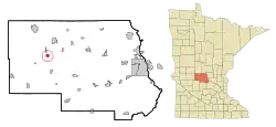 Location of Greenwald within Stearns County, Minnesota | |
| Coordinates: 45°36′N 94°52′W | |
| Country | United States |
| State | Minnesota |
| County | Stearns |
| Area | |
| • Total | 0.71 sq mi (1.85 km2) |
| • Land | 0.71 sq mi (1.85 km2) |
| • Water | 0.00 sq mi (0.00 km2) |
| Elevation | 1,270 ft (387 m) |
| Population | |
| • Total | 222 |
| • Estimate (2019)[3] | 222 |
| • Density | 311.36/sq mi (120.26/km2) |
| Time zone | UTC-6 (Central (CST)) |
| • Summer (DST) | UTC-5 (CDT) |
| ZIP code | 56335 |
| Area code(s) | 320 |
| FIPS code | 27-25874[4] |
| GNIS feature ID | 0644452[5] |
Minnesota State Highway 4 serves as a main route in the community and Interstate 94 passes nearby.
History
A post office called Greenwald has been in operation since 1910.[7] Greenwald is a name partially derived from German, wald meaning "forest".[8]
Geography
According to the United States Census Bureau, the city has a total area of 0.72 square miles (1.86 km2), all land.[9]
The city of Greenwald is located within Grove Township geographically but is a separate entity.
Demographics
| Historical population | |||
|---|---|---|---|
| Census | Pop. | %± | |
| 1920 | 153 | — | |
| 1930 | 237 | 54.9% | |
| 1940 | 233 | −1.7% | |
| 1950 | 207 | −11.2% | |
| 1960 | 266 | 28.5% | |
| 1970 | 244 | −8.3% | |
| 1980 | 259 | 6.1% | |
| 1990 | 209 | −19.3% | |
| 2000 | 201 | −3.8% | |
| 2010 | 222 | 10.4% | |
| 2019 (est.) | 222 | [3] | 0.0% |
| U.S. Decennial Census[10] | |||
2010 census
At the 2010 census,[2] there were 222 people, 98 households and 66 families living in the city. The population density was 308.3 inhabitants per square mile (119.0/km2). There were 104 housing units at an average density of 144.4 per square mile (55.8/km2). The racial makeup of the city was 100.0% White. Hispanic or Latino of any race were 0.9% of the population.
There were 98 households, of which 23.5% had children under the age of 18 living with them, 62.2% were married couples living together, 1.0% had a female householder with no husband present, 4.1% had a male householder with no wife present, and 32.7% were non-families. 29.6% of all households were made up of individuals, and 12.3% had someone living alone who was 65 years of age or older. The average household size was 2.27 and the average family size was 2.77.
The median age was 51.2 years. 20.7% of residents were under the age of 18; 3.7% were between the ages of 18 and 24; 19.8% were from 25 to 44; 34.3% were from 45 to 64; and 21.6% were 65 years of age or older. The gender makeup of the city was 52.7% male and 47.3% female.
2000 census
At the 2000 census,[4] there were 201 people, 85 households and 61 families living in the city. The population density was 260.2 per square mile (100.8/km2). There were 89 housing units at an average density of 115.2 per square mile (44.6/km2). The racial makeup of the city was 100.00% White.
There were 85 households, of which 21.2% had children under the age of 18 living with them, 63.5% were married couples living together, 2.4% had a female householder with no husband present, and 27.1% were non-families. 21.2% of all households were made up of individuals, and 12.9% had someone living alone who was 65 years of age or older. The average household size was 2.36 and the average family size was 2.77.
16.9% of the population were under the age of 18, 11.4% from 18 to 24, 17.9% from 25 to 44, 26.9% from 45 to 64, and 26.9% who were 65 years of age or older. The median age was 46 years. For every 100 females, there were 103.0 males. For every 100 females age 18 and over, there were 103.7 males.
The median household income was $37,000 and the median family income was $42,125. Males had a median income of $31,923 versus $21,071 for females. The per capita income for the city was $17,539. None of the families and 2.4% of the population were living below the poverty line, including no under eighteens and 11.1% of those over 64.
References
- "2019 U.S. Gazetteer Files". United States Census Bureau. Retrieved July 26, 2020.
- "U.S. Census website". United States Census Bureau. Retrieved November 13, 2012.
- "Population and Housing Unit Estimates". United States Census Bureau. May 24, 2020. Retrieved May 27, 2020.
- "U.S. Census website". United States Census Bureau. Retrieved 2008-01-31.
- "US Board on Geographic Names". United States Geological Survey. 2007-10-25. Retrieved 2008-01-31.
- "2010 Census Redistricting Data (Public Law 94-171) Summary File". American FactFinder. U.S. Census Bureau, 2010 Census. Retrieved 23 April 2011.
- "Stearns County". Jim Forte Postal History. Retrieved 8 August 2015.
- Upham, Warren (1920). Minnesota Geographic Names: Their Origin and Historic Significance. Minnesota Historical Society. p. 524.
- "US Gazetteer files 2010". United States Census Bureau. Archived from the original on 2012-01-25. Retrieved 2012-11-13.
- "Census of Population and Housing". Census.gov. Retrieved June 4, 2015.
Municipalities and communities of Stearns County, Minnesota, United States | ||
|---|---|---|
| Cities |
| 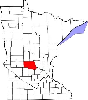 Map of Minnesota highlighting Stearns County |
| Townships |
| |
| CDP | ||
| Unincorporated communities | ||
| Ghost towns/Neighborhoods | ||
| Footnotes | ‡This populated place also has portions in an adjacent county or counties | |
| ||
| Core City |  | ||||
|---|---|---|---|---|---|
| Surrounding communities |
| ||||
| Counties | |||||
‡ indicates that it is partially in the metropolitan area. § indicates a CDP | |||||