Geography of Himachal Pradesh
The state of Himachal Pradesh is spread over an area 55,673 km2 (21,495 sq mi) and is bordered by Jammu and Kashmir and Ladakh on the north, Punjab on the southwest, Haryana on the south, Uttarakhand on the southeast and Tibet on the east. Himachal is a mountainous region, rich in natural resources.
| Area | |
|---|---|
| • Total | 55,673 km2 (21,495 sq mi) |
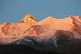
| Highest point | Reo Purgyil (6,816 m or 22,362 ft) |
Characteristics
Elevation ranges from 465 m (1,526 ft) to over 6,816 m (22,362 ft) (Reo Purgyil) above sea level. The region extends from the Shivalik range of mountains (barely mountainous region). There is a noticeable increase in elevation from west to east and from south to north. At 6816 m Reo Purgyil is the highest mountain peak in the state of Himachal Pradesh.
The general physiographic divisions from south to north are:
- The outer Himalayas (Shivaliks)
- The lesser Himalayas (central zone)
- The Great Himalayas (northern zone)
- Zanskar range (shilla Peak-kinnaue, Pangi chamba)
The Shiwalik range consists of lower hills (600 m above sea level). The hills of the region are composed of highly unconsolidated deposits which results in high rates of erosion and deforestation.
The Kangra valley is a longitudinal trough which is at the foot of the Dhauladhar range. Dhauladhar (which means the 'White Peak') has a mean elevation of nearly 4,550 metres. It has a rapid rise of 3,600 m above the Kangra valley. The largest of the lesser Himalayan ranges, the Pir Panjal, branches off from the Greater Himalayan range near the bank of the Sutlej. A number of glaciers exist and several passes lie across the Pir Panjal. The Rohtang Pass (3,978 m) is one of these.
The Great Himalayan range (5,000 to 6,000 metres) runs along the eastern boundary and is slashed across by the Sutlej. Some of the famous passes in this range are Kangla (5,248 m), Bara Lacha (4,512 m), Parang (5,548 m) ,Cheni Pass Churah Pangi (4,400m) and Pin Parvati (4,802 m).
The Zanskar Range, the easternmost range, separates Kinnaur and Spiti from Tibet and Pangi Chamba from Leh Ladkh UT. It has peaks up to 7,026 m high. Some of the well-known peaks are Shilla (6,132 m) and Riwo Phargyul (6,791 m); these are among the highest peaks in this range. There are many glaciers over the Zaskar and the Great Himalayan ranges.
Himachal is well known for its rich flora. Forests cover about 38% of the state's area. It has a variety of wildlife, too.
Himachal has 49 cities and towns. The smallest town is Naina Devi and the largest is Shimla with a total state population of 6,856,509. Urban population is only 7.5% of the state population. Most of the population reside in rural areas.[1]The lesser Himalayas are spotted by a gradual elevation towards the Dhauladhar and the Pir Panjal ranges. The rise is more rapid in the Shimla hills, to the south of which is the high peak of Choodh — Chandni (3647 m). North of the river Sutlej, the rise is steady.
See also
References
| Topics | |||||||
|---|---|---|---|---|---|---|---|
| History | |||||||
| Culture | |||||||
| Jurisdiction | |||||||
| Districts and divisions |
| ||||||
| Major cities | |||||||
| Economy | |||||||
| Geography | |||||||
| Images and Others | |||||||