Geography of Uttarakhand
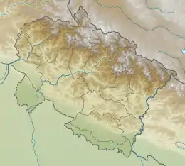
Uttarakhand has a total geographical area of 53,483 km², of which 86% is mountainous and 65% is covered by forest.[1] Most of the northern parts of the state are part of Greater Himalayan ranges also known as Himadri, covered by the high Himalayan peaks and glaciers, while the lower foothills were densely forested till denuded by the British log merchants and later, after independence, by forest contractors. Recent efforts in afforestation, however, have been successful in restoring the situation to some extent. The unique Himalayan ecosystem plays host to many animals (including bharal, snow leopards, leopards and tigers), plants and rare herbs. Two of the India's great rivers, the Ganges and the Yamuna take birth in the glaciers of Uttarakhand state, and are fed by myriad lakes, glacial melts and streams.[2]It is fed by Ganges and Yamuna rivers

 | |
| Continent | Asia |
|---|---|
| Region | |
| Area | Ranked 53,483 km² (20,650 sq mi) |
| • Total | 53,483 km2 (20,650 sq mi) |
| Coastline | 0 km (0 mi) |
| Borders | |
| Highest point | Nanda Devi 7,816 m |
| Lowest point | Sharda Sagar Reservoir 190 m |
| Longest river | Ganges/Ganga |
| Largest lake | Ramganga-Sonanadi Reservoir |
Terrain and vegetation
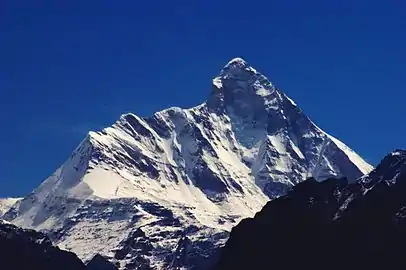
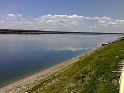
Uttarakhand lies on the southern slope of the Himalaya range, and the climate and vegetation vary greatly with elevation, from glaciers at the highest elevations to tropical forests at the lower elevations. The highest elevations are covered by ice and bare rock. Nanda Devi is the highest land point of Uttarakhand with the altitude of 7,816 metres (25,643 ft) above sea level. Sharda Sagar Reservoir is the lowest land point of Uttarakhand with the altitude of 190 metres (620 ft).[3] Western Himalayan alpine shrub and meadows occur between 3,000 and 5,000 metres (9,800 and 16,400 ft): tundra and alpine meadows cover the highest elevations, Rhododendron-dominated shrublands cover the lower elevations. Western Himalayan subalpine conifer forests lie just below the tree line; at 3,000 to 2,600 metres (9,800 to 8,500 ft) elevation they transition to western Himalayan broadleaf forests, which lie in a belt from 2,600 to 1,500 metres (8,500 to 4,900 ft) elevation. Below 1,500 metres (4,900 ft) elevation lie the Himalayan subtropical pine forests. The drier Terai-Duar savanna and grasslands belt and the Upper Gangetic Plains moist deciduous forests cover the lowlands along the Uttar Pradesh border. This belt is locally known as Bhabar. These lowland forests have mostly been cleared for agriculture, but a few pockets remain.[4]
National parks
Indian National Parks in Uttarakhand include the famous Jim Corbett National Park previously named as Halley National Park (the oldest national park of India) in Nainital District and Pauri Garhwal District, Valley of Flowers National Park & Nanda Devi National Park in Chamoli District, which together are a UNESCO World Heritage Site, Rajaji National Park in Haridwar District, Dehradun District and Pauri Garhwal District and Govind Pashu Vihar National Park and Gangotri National Park in Uttarkashi District.
See also
References
- "State of Uttarakhand" (PDF). Archived from the original (PDF) on 23 May 2012.
- Himalayan Rivers, Lakes and Glaciers. New Delhi: Indus Pub. Co.
- "Ichthyofaunal Diversity of Sharda Sagar Reservoir in Tarai Region" (pdf). Open Academics Journal Index. Retrieved 9 September 2019.
- Negi, S. S. (1995). Uttarakhand: land and people. New Delhi: MD Pub.
| Government |  | ||||||||||||||||
|---|---|---|---|---|---|---|---|---|---|---|---|---|---|---|---|---|---|
| History |
| ||||||||||||||||
| Geography and Ecology |
| ||||||||||||||||
| Demographics |
| ||||||||||||||||
| Administrative divisions |
| ||||||||||||||||
| Politics | |||||||||||||||||
| Tourism |
| ||||||||||||||||
| Sports | |||||||||||||||||
| Other topics | |||||||||||||||||
| Districts |
| ||||||||||||||||
| Major cities | |||||||||||||||||