Gipsy Hill
Gipsy Hill in south London is a leafy and hilly neighbourhood spanning the southern parts of the London Boroughs of Lambeth and Southwark characterised for its great views of the City of London.
| Gipsy Hill | |
|---|---|
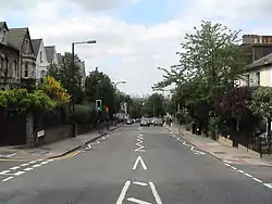 View down the upper straight of the street, Gipsy Hill, looking north towards the City of London | |
 Gipsy Hill Location within Greater London | |
| Population | 13,712 (2011 Census. Ward)[1] |
| OS grid reference | TQ332710 |
| London borough | |
| Ceremonial county | Greater London |
| Region | |
| Country | England |
| Sovereign state | United Kingdom |
| Post town | LONDON |
| Postcode district | SE19, SE27 |
| Dialling code | 020 |
| Police | Metropolitan |
| Fire | London |
| Ambulance | London |
| UK Parliament | |
| London Assembly | |
Historically, north of its traditional Westow-Central Hill southern limit, it was split between the southern projections of the West Norwood daughter parish of Lambeth and the St Giles church daughter parish of Camberwell in Surrey until urban reforms of 1889 creating the County of London. It takes in, due to a diagonal, slightly weaving border, somewhat less of the London Borough of Southwark and has a ridge-top border along the retail/services/leisure street Westow Hill and residential street Central Hill with Upper Norwood in the London Borough of Croydon.
History and Geography
Gipsy Hill is the name of the central road that runs south from Gipsy Road, near where it meets South Croxted Road, up to Central Hill and Westow Hill (a brief eastern continuation). The latter are two crest-top roads marking the limit of Upper Norwood, part of the London Borough (and, here, former parish) of Croydon. Due to its station, as common across London, the name has been taken to extend to encompass a wider, in this case, upper hill-side zone in extreme projections of the two relevant boroughs. It takes its name from the presence of Gypsies in what was, until the 19th century, sparsely populated rurality.[2][3] On 11 August 1668, Samuel Pepys recorded in his diary that his wife had visited "the gypsies at Lambeth"; this is the only land in the parish which frequently hosted gypsies.[4]
At the east and west ends of the hill which descends more gently north, are the forked sources of the former River Effra.
The hill and particularly its southern climactic ridge are part of a much larger formation, the Norwood Ridge.
The area rapidly developed after Gipsy Hill railway station was opened in 1856, with large houses being constructed (most now subdivided) and blocks of council-built housing in the mid-20th century, a little remaining as assisted (Social) housing.[2] An 18-room nuclear bunker was constructed between 1963 and 1966 as part of a block of flats on the Central Hill Estate called Pear Tree House on Lunham Road.[5]
Politics
For the west, Gipsy Hill ward is represented by three elected members of Lambeth Borough Council; for fair apportionment it extends into West Norwood and West Dulwich. For the east, since 2018, two members represent Dulwich Wood ward on Southwark Council, which similarly extends into the Sydenham Hill area of what was traditionally Dulwich.[6]
Buildings and facilities
Police
Gipsy Hill Police Station is on Central Hill, the western continuation of Westow Hill. It is London's highest station, an old Bench Mark SW, opposite, stated 360.6 feet (109.9 m) Above Ordnance Datum.[7]
Pubs and independent breweries
Two of the pubs are central on the street Gipsy Hill: The Colby Arms and The Great Southern. Higher but before Westow Hill, The Railway Bell is on Cawnpore Street, a side street.[8] The Two Towers and Paxton are on the relatively low, north-west Gipsy Road.
Two independent companies brew beer commercially: the Gipsy Hill Brewing Co. and the London Beer Factory.[9]
Schools
- Elm Wood Primary School, Carnac Street.
- Kingswood Primary School, Gipsy Road (on two sites).[10]
- Park Campus Academy, Gipsy Road.
- Paxton Primary School, Woodland Road.[11]
Elm Wood, Kingswood and Paxton schools are all members of The Gipsy Hill Federation.[12]
The nearest private school is in West Dulwich.
Churches
The following congregations meet in buildings that are readily identified as places of worship:
- Berridge Road Community Church (Anglican), Berridge Road, SE19 1EF[13]
- Christ Church, Gipsy Hill (Anglican), 1 Highland Road SE19 1DP[14]
- Kingdom Hall of Jehovah's Witnesses, Whiteley Road, SE19 1JT
- Upper Norwood Methodist Church, Westow Hill, SE19 1TQ[15]
These buildings were constructed as places of worship but are now used for other purposes:
- Former Gipsy Hill Wesleyan Chapel; converted into flats.
- Former Gipsy Road Baptist Church; upper part: housing conversion; ground floor: nursery.
Nearest places
Nearest stations
Notable residents
- Errol Brown of Hot Chocolate, lived in Alexandra Drive, Gipsy Hill
- Daniel Kitson, comedian, known for Phoenix Nights
- Nadia Sawalha, actress and television presenter
- Kate Thornton, former presenter of The X Factor
- Nathaniel Chalobah, Watford football player
- Martin Orbell, sound engineer for The Boomtown Rats and the Sex Pistols
- Nigel Eaton, hurdy gurdy player for Jimmy Page, Robert Plant, Scott Walker, Tony Ferrino
- Krept & Konan, rappers
- Isy Suttie, actress and comedian
- Elis James, comedian, broadcaster and actor
- Patrick Grant, designer and judge on The Great British Sewing Bee
- K-Trap, rapper
References
- "Lambeth Ward population 2011". Neighbourhood Statistics. Office for National Statistics. Retrieved 12 October 2016.
- Willey, Russ. Chambers London Gazetteer, p 192
- http://romanygenes.com/#/the-norwood-gypsies/4574799978
- "Tuesday 11 August 1668 (Pepys' Diary)". Pepysdiary.com. Retrieved 18 August 2013.
- "The secret plan in place for if a nuclear bomb had been dropped on Croydon". Croydon Advertiser. 15 December 2017. Retrieved 4 August 2020.
- https://www.southwark.gov.uk/test/empowering-communities-programme
- https://maps.nls.uk/geo/explore/#zoom=19&lat=51.41964&lon=-0.08437&layers=168&b=7 and see List of highest places in Greater London
- https://www.pubsgalore.co.uk/areas/gipsy-hill/greater-london/
- "5 Places to Live in South London". UK Investor. Retrieved 29 August 2016.
- "Kingswood Primary School". Ofsted. Retrieved 14 September 2015.
- "Paxton Primary School". Ofsted. Retrieved 14 September 2015.
- "The Gipsy Hill Federation". Retrieved 14 September 2015.
- "Christ Church Gipsy Hill". Gipsyhill.org.uk. Retrieved 18 August 2013.
- "Christ Church Gipsy Hill". Gipsyhill.org.uk. Retrieved 18 August 2013.
- Balston, James (7 December 2012). "The Triangle SE19: Upper Norwood Methodist Church". Thetrianglese19.blogspot.co.uk. Retrieved 18 August 2013.