Hacılar
Hacılar is a town and district of Kayseri Province in the Central Anatolia region of Turkey. The mayor is Ahmet Herdem (AKP).
Hacılar | |
|---|---|
 Hacılar | |
| Coordinates: 38°38′59″N 35°27′01″E | |
| Country | Turkey |
| Province | Kayseri |
| Government | |
| • Mayor | Ahmet Herdem (AKP) |
| • Kaymakam | Harun Öksüz |
| Area | |
| • District | 194.25 km2 (75.00 sq mi) |
| Population (2012)[2] | |
| • Urban | 11,504 |
| • District | 12,381 |
| • District density | 64/km2 (170/sq mi) |
| Website | www.hacilar.bel.tr |
History
The establisher clans of Hacılar village came here in the 15th century from Hacılar town and its vicinity in Kozan district of Adana. If the founders of the village belong to Hacılar obas, they must be from Bayat tribe.
The people of Hacılar first settled in the "Dört Kuyular" location of the Beğendik vineyards between the years 1411-1500, and abandoned the Dört Kuyular location in 1726 as a result of the pressure of the Avşar Tribe, who gained big power in the Kayseri.
Hacılar, which was previously affiliated to Kayseri Central District and then to Melikgazi District in administrative terms, became a diverse district as of 09.09.1991 with the Law No. 3647 published in Resmî Gazete dated 18.05.1990.
Geography
The district was established in the south of Kayseri province, on the slopes of Mount Erciyes. 11 km from away Kayseri, it is close to Eğribucak Vineyards, which are famous for their mulberries. The central altitude of the district is 1350 m. An important part of Mount Erciyes is within the boundaries of the district. There is Melikgazi in the north and east of the district, Develi in the south and İncesu District in the west. There are around 15 mountains of various sizes, including Mount Erciyes, within the boundaries of the district.
The district land consists of volcanic rocks and hills, except for small cultivation areas and gardens. The land is inclined from south to north and from west to east. Its climate is cold and rainy in winters and hot and dry in summers. However, it is a district worth visiting with its natural beauty, recreation areas, vineyards and gardens. The district has the area of 208 km². There are no significant streams and lakes within the boundaries of the district.
References
- "Area of regions (including lakes), km²". Regional Statistics Database. Turkish Statistical Institute. 2002. Retrieved 2013-03-05.
- "Population of province/district centers and towns/villages by districts - 2012". Address Based Population Registration System (ABPRS) Database. Turkish Statistical Institute. Retrieved 2013-02-27.
Hacılar in Kayseri Province of Turkey | |||||||||||||||||||||||||||
|---|---|---|---|---|---|---|---|---|---|---|---|---|---|---|---|---|---|---|---|---|---|---|---|---|---|---|---|
| Districts | 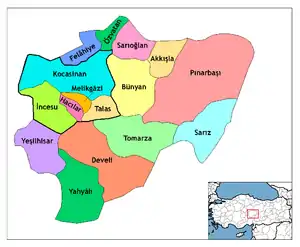 Districts of Kayseri | ||||||||||||||||||||||||||
| |||||||||||||||||||||||||||
Metropolitan municipalities are bolded. | |||||||||||||||||||||||||||