Hackensack, Minnesota
Hackensack is a city in Cass County, Minnesota, United States. As of 2020, the city's population was 244.[5] It is part of the Brainerd Micropolitan Statistical Area. Although the population is small, it is located within a ten-mile radius of 127 lakes, so during the warm months there is plenty of business.[6] The city center is home to gift stores, the Big Dipper ice cream shop and restaurant, Udom's Thai restaurant, Lucette's Pizza and Pub, and much more.
Hackensack | |
|---|---|
| Nickname(s): "Home of Paul Bunyan's Sweetheart" | |
 Location of Hackensack within Cass County, Minnesota | |
| Coordinates: 46°55′44″N 94°31′18″W | |
| Country | United States |
| State | Minnesota |
| County | Cass |
| Area | |
| • Total | 1.03 sq mi (2.66 km2) |
| • Land | 1.02 sq mi (2.63 km2) |
| • Water | 0.01 sq mi (0.02 km2) |
| Elevation | 1,391 ft (424 m) |
| Population | |
| • Total | 313 |
| • Estimate (2019)[3] | 310 |
| • Density | 305.12/sq mi (117.82/km2) |
| Time zone | UTC-6 (Central (CST)) |
| • Summer (DST) | UTC-5 (CDT) |
| ZIP code | 56452 |
| Area code(s) | 218 |
| FIPS code | 27-26378 |
| GNIS feature ID | 0656495[4] |
| Website | hackensackchamber.com |
Hackensack declares itself the home of Paul Bunyan's sweetheart, Lucette.[6] The community celebrates Sweetheart Days every July, including events such as a parade, games, and food vendors.[7]
History
A post office called Hackensack has been in operation since 1888.[8] The city is named after Hackensack, New Jersey.[9]
The residents of Hackensack first described their town as the home of Paul Bunyan's sweetheart Lucette in the 1940s, when a sculpture depicting her was placed in City Park.[10] A seventeen-foot-tall fiberglass sculpture of Lucette replaced the original in 1991.[11]

Geography
According to the United States Census Bureau, the city has a total area of 1.02 square miles (2.64 km2), of which 1.01 square miles (2.62 km2) is land and 0.01 square miles (0.03 km2) is water.[12]
Minnesota State Highway 371 serves as a main route in the community.
Hackensack is located along the eastern shore of Birch Lake and maintains an asphalt boat ramp for lake access. Other lakes in the area include Pleasant Lake and Ten Mile Lake, the second-deepest natural lake in the state.[13]
The Paul Bunyan State Trail passes through the city along the east shore of Birch lake.
Demographics
| Historical population | |||
|---|---|---|---|
| Census | Pop. | %± | |
| 1910 | 84 | — | |
| 1920 | 200 | 138.1% | |
| 1930 | 256 | 28.0% | |
| 1940 | 264 | 3.1% | |
| 1950 | 272 | 3.0% | |
| 1960 | 204 | −25.0% | |
| 1970 | 220 | 7.8% | |
| 1980 | 285 | 29.5% | |
| 1990 | 245 | −14.0% | |
| 2000 | 285 | 16.3% | |
| 2010 | 313 | 9.8% | |
| 2019 (est.) | 310 | [3] | −1.0% |
| U.S. Decennial Census[14] 2013 Estimate[15] | |||
2010 census
As of the census[2] of 2010, there were 313 people, 143 households, and 79 families living in the city. The population density was 309.9 inhabitants per square mile (119.7/km2). There were 194 housing units at an average density of 192.1 per square mile (74.2/km2). The racial makeup of the city was 95.8% White, 1.0% Native American, and 3.2% from two or more races. Hispanic or Latino of any race were 0.3% of the population.
There were 143 households, of which 25.9% had children under the age of 18 living with them, 42.0% were married couples living together, 4.9% had a female householder with no husband present, 8.4% had a male householder with no wife present, and 44.8% were non-families. 38.5% of all households were made up of individuals, and 14% had someone living alone who was 65 years of age or older. The average household size was 2.13 and the average family size was 2.85.
The median age in the city was 45.1 years. 19.8% of residents were under the age of 18; 9.3% were between the ages of 18 and 24; 20.8% were from 25 to 44; 24.9% were from 45 to 64; and 25.2% were 65 years of age or older. The gender makeup of the city was 54.3% male and 45.7% female.
2000 census
As of the census of 2000, there were 285 people, 132 households, and 76 families living in the city. The population density was 400.6 people per square mile (155.0/km2). There were 187 housing units at an average density of 262.9 per square mile (101.7/km2). The racial makeup of the city was 96.84% White, 2.11% Native American, and 1.05% from two or more races. Hispanic or Latino of any race were 0.35% of the population.
There were 132 households, out of which 19.7% had children under the age of 18 living with them, 48.5% were married couples living together, 4.5% had a female householder with no husband present, and 42.4% were non-families. 36.4% of all households were made up of individuals, and 18.9% had someone living alone who was 65 years of age or older. The average household size was 2.16 and the average family size was 2.74.
In the city, the population was spread out, with 20.4% under the age of 18, 7.4% from 18 to 24, 23.9% from 25 to 44, 21.8% from 45 to 64, and 26.7% who were 65 years of age or older. The median age was 44 years. For every 100 females, there were 88.7 males. For every 100 females age 18 and over, there were 90.8 males.
The median income for a household in the city was $24,375, and the median income for a family was $31,094. Males had a median income of $18,438 versus $25,556 for females. The per capita income for the city was $12,768. About 3.3% of families and 10.5% of the population were below the poverty line, including 2.0% of those under the age of eighteen and 10.8% of those 65 or over.
Education
Hackensack Public Schools are part of the Walker-Hackensack-Akeley School District. Schools in the district include Walker-Hackensack-Akeley Elementary School and Walker-Hackensack-Akeley High School (WHA).
Hackensack students attend Walker-Hackensack-Akeley High School which is located in Walker.
Dr. Mary Donohue Stetz is the Superintendent of Schools.[16]
Media
TV stations
Hackensack is part of the Minneapolis / Saint Paul television market.
KCCW-TV is a full power station licensed to nearby Walker on channel 12 with transmitter located east of Hackensack on Woman Lake Road (Cass County Road 5). It does not originate programming but rebroadcasts WCCO-TV with no local input.
Cable and satellite television signals are also available.
References
- "2019 U.S. Gazetteer Files". United States Census Bureau. Retrieved July 26, 2020.
- "U.S. Census website". United States Census Bureau. Retrieved 2012-11-13.
- "Population and Housing Unit Estimates". United States Census Bureau. May 24, 2020. Retrieved May 27, 2020.
- "US Board on Geographic Names". United States Geological Survey. 2007-10-25. Retrieved 2008-01-31.
- "Pros and Cons of Living in Hackensack, Minnesota - Citytistics". citytistics.com. Retrieved 2021-02-03.
- "Welcome to Hackensack, Minnesota". Hackensack Chamber of Commerce. Retrieved November 29, 2020.
- "Sweetheart Days in Hackensack July 9–13". The Pilot-Independent. Walker, Minnesota. November 30, 2018. Retrieved November 29, 2020.
- "Cass County". Jim Forte Postal History. Retrieved 12 April 2015.
- Upham, Warren (1920). Minnesota Geographic Names: Their Origin and Historic Significance. Minnesota Historical Society. p. 89.
- "'Ballad of Lucette' to be performed in Hackensack". Brainerd Dispatch. June 29, 2000. Retrieved November 29, 2020.
- "Hackensack, Minnesota: Paul Bunyan's Sweetheart Lucette". Roadside America. Retrieved November 29, 2020.
- "US Gazetteer files 2010". United States Census Bureau. Retrieved 2012-11-13.
- "Minnesota Facts and Figures," MN DNR, 2008
- United States Census Bureau. "Census of Population and Housing". Retrieved July 14, 2014.
- "Population Estimates". United States Census Bureau. Archived from the original on 2014-05-22. Retrieved 2014-07-14.
- "Walker Hackensack Akeley Schools". Walker Hackensack Akeley Schools. Retrieved 2012-06-26.
External links
| Wikimedia Commons has media related to Hackensack, Minnesota. |
Municipalities and communities of Cass County, Minnesota, United States | ||
|---|---|---|
| Cities | 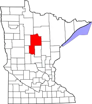 Map of Minnesota highlighting Cass County | |
| Townships |
| |
| Unorganized territories | ||
| CDP | ||
| Unincorporated communities | ||
| Indian reservation | ||
| Ghost town | ||
| Footnotes | ‡This populated place also has portions in an adjacent county or counties | |
| ||
Cities in the Brainerd Lakes area, Minnesota | |||||
|---|---|---|---|---|---|
| Core City | 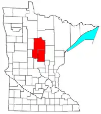 | ||||
| Surrounding communities |
| ||||
| Counties | |||||
† indicates a county seat. ‡ indicates that it is partially in the micropolitan area. § indicates a CDP. | |||||
| Authority control |
|---|