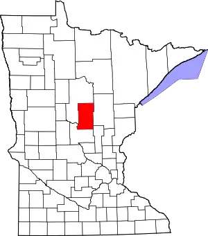
Crow Wing County, Minnesota
Crow Wing County is a county in the East Central part of the U.S. state of Minnesota. As of the 2010 United States Census, the population was 62,500.[1] Its county seat is Brainerd.[2] The county was formed in 1857, and was organized in 1870.[3]
Crow Wing County | |
|---|---|
 | |
 Location within the U.S. state of Minnesota | |
 Minnesota's location within the U.S. | |
| Coordinates: 46°29′N 94°04′W | |
| Country | |
| State | |
| Founded | May 23, 1857 (created) March 3, 1870 (organized) |
| Named for | Crow Wing River |
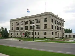
| Seat | Brainerd |
| Largest city | Brainerd |
| Area | |
| • Total | 1,157 sq mi (3,000 km2) |
| • Land | 999 sq mi (2,590 km2) |
| • Water | 157 sq mi (410 km2) 14%% |
| Population (2010) | |
| • Total | 62,500 |
| • Estimate (2019) | 65,055 |
| • Density | 64.5/sq mi (24.9/km2) |
| Time zone | UTC−6 (Central) |
| • Summer (DST) | UTC−5 (CDT) |
| Congressional district | 8th |
| Website | www |
Crow Wing County is included in the Brainerd, MN Micropolitan Statistical Area.
History
This area was long occupied by the Ojibwe people, known as Chippewa in the United States. In addition, numerous Dakota people lived in central and southern Minnesota before European settlement. European Americans established a trading post by 1837 in this area, on the east side of the Mississippi River opposite the mouth of the Crow Wing River. The post (named Crow Wing) soon became a center of trading with the region's Native Americans, with a general-supply store that served the area. By 1866, the village contained about 600 whites and Chippewa; it was a major population center. The territorial government enacted the county's creation on May 23, 1857, and named Crow Wing the county seat.[4] The governmental structure of the county was not effected until March 3, 1870. The county was named for the river,[5] which is named for an island in the river that resembles a crow's wing.
Brainerd township was founded in 1870 when the Northern Pacific Railroad selected the site for a crossing of the Mississippi River. It attracted development and population, soon surpassing Crow Wing. It was also designated as the new county seat, drawing off more residents and businesses from what became known as a ghost town, Old Crow Wing. Crow Wing State Park encompasses much of the former village site along the river.
Brainerd City was incorporated on November 19, 1881, named for Lawrence Brainerd, the father-in-law of J. Gregory Smith, the first president of the Northern Pacific Railroad Company. Smith served as governor of Vermont from 1863 to 1865 before moving west. He is called the father and founder of Brainerd. Lawrence Brainerd was the first president of the Vermont Central Railroad. The Northern Pacific Railroad ran a special train as its first service to Brainerd on March 11, 1871. Its regular passenger service began the next September. The first passenger train from the Twin Cities, by way of Sauk Rapids, arrived on November 1, 1877.
On February 18, 1887, the Minnesota legislature annexed part of Cass County (west of the Mississippi) to Crow Wing County, which doubled the former area of Crow Wing County.
Geography
Crow Wing County has an area of 1,157 square miles (3,000 km2), of which 999 square miles (2,590 km2) is land and 157 square miles (410 km2) (14%) is water.[7]
Topography and vegetation
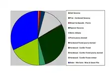
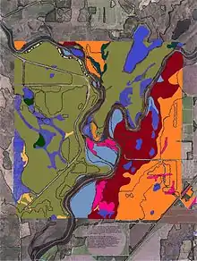
Crow Wing County has two state forests, the Crow Wing State Forest and the Emily State Forest. The Cuyuna Lakes State Trail lies in the Upper Mississippi River Basin. The topography is gently rolling to flat, mostly wooded and heavily dotted with waters and wetlands.[8] It is home to an abundance of wildlife, including white-tailed deer, cottontail rabbit, snowshoe hare, raccoon, red fox, gray fox, coyote, mink, muskrat, squirrels, beaver, occasional American black bear, Bald eagle, osprey and many other waterfowl.
Lakes and rivers
The main river is the Mississippi River, and there are several smaller streams. It has about 417 recognized lakes. The top ten by size are:
- Gull Lake – 9,419 acres (38.12 km2)
- Pelican Lake – 8,254 acres (33.40 km2)
- Upper and Lower White Fish Lake – 7,372 acres (29.83 km2)
- North Long Lake – 5,997 acres (24.27 km2)
- Lake Edward – 2,576 acres (10.42 km2)
- Bay Lake – 2,393 acres (9.68 km2)
- Cross Lake – 1,752 acres (7.09 km2)
- Round Lake – 1,645 acres (6.66 km2)
- Big Trout Lake – 1,343 acres (5.43 km2)
- Lower South Long Lake – 1,312 acres (5.31 km2)
Major highways
Adjacent counties
- Aitkin County - northeast
- Mille Lacs County - southeast
- Morrison County - southwest
- Cass County - northwest, north
Protected areas[8]
- Crow Wing State Forest
- Crow Wing State Park (part)
- Cuyuna Country State Recreation Area
- Cuyuna Lakes State Trail (within Cuyuna Country SRA)[9]
- Duck Lakes State Wildlife Management Area
- Emily State Forest
- Loerch State Wildlife Management Area
- Mille Lacs Moraine Scientific and Natural Area
- Safari North Wildlife Park
- Upper Dean State Wildlife Management Area
Superfund site and environmental damage
The presence of railroads increased development in the county, but also brought environmental problems. The Burlington Northern (Brainerd/Baxter) EPA Superfund site is between Brainerd and Baxter. Burlington Northern Railroad had a treatment plant in Crow Wing County for railroad ties, to protect the wood from weather and insects. Wastewater generated from the wood-treating process was sent to two shallow, unlined ponds. This created sludge that contaminated both the underlying soils and the groundwater with creosote and polynuclear aromatic hydrocarbons (PAHs).[10]
Demographics
| Historical population | |||
|---|---|---|---|
| Census | Pop. | %± | |
| 1860 | 269 | — | |
| 1870 | 200 | −25.7% | |
| 1880 | 2,319 | 1,059.5% | |
| 1890 | 8,852 | 281.7% | |
| 1900 | 14,250 | 61.0% | |
| 1910 | 16,861 | 18.3% | |
| 1920 | 24,566 | 45.7% | |
| 1930 | 25,627 | 4.3% | |
| 1940 | 30,226 | 17.9% | |
| 1950 | 30,875 | 2.1% | |
| 1960 | 32,134 | 4.1% | |
| 1970 | 34,826 | 8.4% | |
| 1980 | 41,722 | 19.8% | |
| 1990 | 44,249 | 6.1% | |
| 2000 | 55,099 | 24.5% | |
| 2010 | 62,500 | 13.4% | |
| 2019 (est.) | 65,055 | [11] | 4.1% |
| US Decennial Census[12] 1790-1960[13] 1900-1990[14] 1990-2000[15] 2010-2019[1] | |||
2000 census
As of the 2000 United States Census, there were 55,099 people, 22,250 households, and 15,174 families in the county. The population density was 55.2/sqmi (21.3/km2). There were 33,483 housing units at an average density of 33.5/sqmi (12.9/km2). The racial makeup of the county was 97.64% White, 0.31% Black or African American, 0.78% Native American, 0.28% Asian, 0.01% Pacific Islander, 0.20% from other races, and 0.78% from two or more races. 0.69% of the population were Hispanic or Latino of any race. 32.5% were of German, 16.4% Norwegian, 9.4% Swedish, 6.2% Irish and 5.2% American ancestry.
There were 22,250 households, out of which 30.20% had children under the age of 18 living with them, 56.70% were married couples living together, 8.00% had a female householder with no husband present, and 31.80% were non-families. 26.40% of all households were made up of individuals, and 11.70% had someone living alone who was 65 years of age or older. The average household size was 2.43 and the average family size was 2.93.
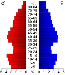
The county population contained 24.80% under the age of 18, 8.10% from 18 to 24, 25.60% from 25 to 44, 24.40% from 45 to 64, and 17.10% who were 65 years of age or older. The median age was 39 years. For every 100 females there were 96.80 males. For every 100 females age 18 and over, there were 94.50 males.
The median income for a household in the county was $37,589, and the median income for a family was $44,847. Males had a median income of $33,838 versus $22,896 for females. The per capita income for the county was $19,174. About 6.50% of families and 9.80% of the population were below the poverty line, including 11.40% of those under age 18 and 9.90% of those age 65 or over.
Communities
Cities
Census-designated place
Unincorporated communities
Townships
- Bay Lake Township
- Center Township
- Crow Wing Township
- Daggett Brook Township
- Deerwood Township
- Fairfield Township
- Fort Ripley Township
- Gail Lake Township
- Garrison Township
- Ideal Township
- Irondale Township
- Jenkins Township
- Lake Edwards Township
- Little Pine Township
- Long Lake Township
- Maple Grove Township
- Mission Township
- Nokay Lake Township
- Oak Lawn Township
- Pelican Township
- Perry Lake Township
- Platte Lake Township
- Rabbit Lake Township
- Roosevelt Township
- Ross Lake Township
- Saint Mathias Township
- Sibley Township (former)
- Timothy Township
- Wolford Township
Unorganized territories
Government and politics
Crow Wing County has voted Republican for several decades. In only one presidential election since 1976 has the county selected the Democratic candidate.
| Year | Republican | Democratic | Third parties |
|---|---|---|---|
| 2020 | 63.9% 25,676 | 34.2% 13,726 | 1.3% 549 |
| 2016 | 62.2% 22,287 | 30.6% 10,982 | 7.2% 2,573 |
| 2012 | 55.6% 19,415 | 42.3% 14,760 | 2.1% 745 |
| 2008 | 52.8% 18,567 | 45.1% 15,859 | 2.1% 739 |
| 2004 | 57.0% 19,106 | 41.8% 14,005 | 1.3% 434 |
| 2000 | 53.5% 15,035 | 40.0% 11,255 | 6.5% 1,838 |
| 1996 | 40.4% 10,095 | 44.7% 11,156 | 14.9% 3,712 |
| 1992 | 37.1% 9,112 | 36.3% 8,896 | 26.6% 6,531 |
| 1988 | 52.7% 11,017 | 46.3% 9,674 | 1.1% 220 |
| 1984 | 56.2% 11,362 | 43.1% 8,719 | 0.8% 151 |
| 1980 | 50.0% 10,844 | 43.0% 9,323 | 7.0% 1,510 |
| 1976 | 41.3% 8,072 | 54.5% 10,653 | 4.3% 839 |
| 1972 | 53.0% 8,774 | 44.3% 7,328 | 2.7% 449 |
| 1968 | 45.2% 6,687 | 50.1% 7,411 | 4.7% 697 |
| 1964 | 35.8% 5,131 | 64.1% 9,197 | 0.2% 21 |
| 1960 | 52.9% 7,727 | 46.8% 6,835 | 0.4% 52 |
| 1956 | 54.4% 6,657 | 45.4% 5,556 | 0.3% 30 |
| 1952 | 54.0% 6,992 | 45.4% 5,883 | 0.6% 81 |
| 1948 | 39.7% 4,702 | 57.2% 6,773 | 3.1% 370 |
| 1944 | 44.7% 4,500 | 54.7% 5,504 | 0.6% 63 |
| 1940 | 44.0% 5,524 | 54.8% 6,876 | 1.2% 150 |
| 1936 | 33.8% 3,611 | 61.5% 6,561 | 4.7% 501 |
| 1932 | 41.7% 3,991 | 52.9% 5,068 | 5.4% 519 |
| 1928 | 67.9% 6,436 | 30.1% 2,851 | 2.1% 196 |
| 1924 | 50.1% 4,230 | 4.9% 417 | 45.0% 3,802 |
| 1920 | 70.3% 5,262 | 14.4% 1,077 | 15.3% 1,142 |
| 1916 | 44.4% 1,715 | 40.6% 1,568 | 15.0% 578 |
| 1912 | 21.0% 691 | 21.5% 709 | 57.5% 1,897 |
| 1908 | 59.4% 1,681 | 23.4% 661 | 17.2% 487 |
| 1904 | 77.0% 2,150 | 11.9% 333 | 11.1% 309 |
| 1900 | 67.2% 1,803 | 30.0% 804 | 2.8% 75 |
| 1896 | 59.4% 1,701 | 37.2% 1,066 | 3.5% 99 |
| 1892 | 53.1% 916 | 30.1% 519 | 16.8% 290 |
| Position | Name | District | |
|---|---|---|---|
| Commissioner | Paul Koering | District 1 | |
| Commissioner | Bill Brekken | District 2 | |
| Commissioner and Chair | Steve Barrows | District 3 | |
| Commissioner | Rosemary Franzen | District 4 | |
| Commissioner and Vice Chair | Doug Houge | District 5 | |
| Position | Name | Affiliation | District | |
|---|---|---|---|---|
| Senate | Carrie Ruud[18] | Republican | District 10 | |
| House of Representatives | Josh Heintzeman[19] | Republican | District 10A | |
| House of Representatives | Dale Lueck[20] | Republican | District 10B | |
| Position | Name | Affiliation | District | |
|---|---|---|---|---|
| House of Representatives | Pete Stauber[21] | Republican | 8th | |
| Senate | Amy Klobuchar[22] | Democrat | N/A | |
| Senate | Tina Smith[23] | Democrat | N/A | |
See also
References
- "State & County QuickFacts". United States Census Bureau. Archived from the original on July 9, 2011. Retrieved August 31, 2013.
- "Find a County". National Association of Counties. Archived from the original on May 31, 2011. Retrieved June 7, 2011.
- "Minnesota Place Names". Minnesota Historical Society. Archived from the original on October 27, 2014. Retrieved March 17, 2014.
- Ripley, George; Dana, Charles A., eds. (1879). . The American Cyclopædia.
- Warren Upham (1920). Minnesota Geographic Names: Their Origin and Historic Significance. Minnesota Historical Society. p. 154.
- Nelson, Steven (2011).Savanna Soils of Minnesota. Minnesota: Self. pp. 53-56. ISBN 978-0-615-50320-2.
- "2010 Census Gazetteer Files". US Census Bureau. August 22, 2012. Archived from the original on September 21, 2013. Retrieved October 6, 2014.
- Crow Wing County MN Google Maps (accessed March 7, 2019)
- Minnesota Div of Natural Resources: Cuyuna Lakes State Trail (accessed March 7, 2019)
- "Burlington Northern (Brainerd/Baxter) Fact Sheet" Archived December 5, 2012, at the Wayback Machine, EPA, July 13, 2012
- "Population and Housing Unit Estimates". Retrieved March 26, 2020.
- "US Decennial Census". US Census Bureau. Archived from the original on April 26, 2015. Retrieved October 6, 2014.
- "Historical Census Browser". University of Virginia Library. Retrieved October 6, 2014.
- "Population of Counties by Decennial Census: 1900 to 1990". US Census Bureau. Retrieved October 6, 2014.
- "Census 2000 PHC-T-4. Ranking Tables for Counties: 1990 and 2000" (PDF). US Census Bureau. Retrieved October 6, 2014.
- Leip, David. "Atlas of US Presidential Elections". uselectionatlas.org. Retrieved April 10, 2018.
- "County Board | Crow Wing County, MN - Official Website". crowwing.us. Retrieved June 25, 2020.
- "MN State Senate". www.senate.mn. Retrieved June 25, 2020.
- "Rep. Josh Heintzeman (10A) - Minnesota House of Representatives". www.house.leg.state.mn.us. Retrieved June 25, 2020.
- "Rep. Dale Lueck (10B) - Minnesota House of Representatives". www.house.leg.state.mn.us. Retrieved June 25, 2020.
- "Representative Pete Stauber". Representative Pete Stauber. Retrieved June 24, 2020.
- "U.S. Senator Amy Klobuchar". www.klobuchar.senate.gov. Retrieved June 24, 2020.
- "Home". Senator Tina Smith. Retrieved June 24, 2020.
External links
| Wikisource has the text of the 1879 American Cyclopædia article Crow Wing. |
Places adjacent to Crow Wing County, Minnesota | ||||||||||
|---|---|---|---|---|---|---|---|---|---|---|
| ||||||||||
Municipalities and communities of Crow Wing County, Minnesota, United States | ||
|---|---|---|
| Cities | Map of Minnesota highlighting Crow Wing County | |
| Townships | ||
| Unorganized territories | ||
| CDP | ||
| Unincorporated communities | ||
| Indian reservation | ||
| Ghost towns | ||
| Footnotes | ‡This populated place also has portions in an adjacent county or counties | |
| ||
Cities in the Brainerd Lakes area, Minnesota | |||||
|---|---|---|---|---|---|
| Core City | 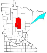 | ||||
| Surrounding communities |
| ||||
| Counties | |||||
† indicates a county seat. ‡ indicates that it is partially in the micropolitan area. § indicates a CDP. | |||||

| Authority control |
|---|
