Hannan District
Hannan District (simplified Chinese: 汉南区; traditional Chinese: 漢南區; pinyin: Hànnán Qū) is one of 13 urban districts of the prefecture-level city of Wuhan, the capital of Hubei Province, China. It is the least-populous of Wuhan's districts,[3] and is situated on the northern (left) bank of the Yangtze River. It borders the districts of Caidian to the north and Jiangxia to the east across the Yangtze, as well as the prefecture-level cities of Xianning and Jingzhou (for a sliver) to the south; it also borders the directly administered county-level city of Xiantao to the west.
Hannan
汉南区 | ||||||||||||||||||||||||||||||||||||
|---|---|---|---|---|---|---|---|---|---|---|---|---|---|---|---|---|---|---|---|---|---|---|---|---|---|---|---|---|---|---|---|---|---|---|---|---|
 Hannan Shamao Square 汉南区纱帽广场 | ||||||||||||||||||||||||||||||||||||

| ||||||||||||||||||||||||||||||||||||
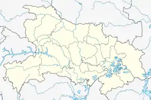 Hannan Location in Hubei | ||||||||||||||||||||||||||||||||||||
| Coordinates: 30°18′37″N 114°04′55″E[1] | ||||||||||||||||||||||||||||||||||||
| Country | People's Republic of China | |||||||||||||||||||||||||||||||||||
| Province | Hubei | |||||||||||||||||||||||||||||||||||
| Sub-provincial city | Wuhan | |||||||||||||||||||||||||||||||||||
| Subdistricts | 4 | |||||||||||||||||||||||||||||||||||
| Area | ||||||||||||||||||||||||||||||||||||
| • Total | 287.70 km2 (111.08 sq mi) | |||||||||||||||||||||||||||||||||||
| Population (2010)[3] | ||||||||||||||||||||||||||||||||||||
| • Total | 114,970 | |||||||||||||||||||||||||||||||||||
| • Density | 400/km2 (1,000/sq mi) | |||||||||||||||||||||||||||||||||||
| Time zone | UTC+8 (China Standard) | |||||||||||||||||||||||||||||||||||
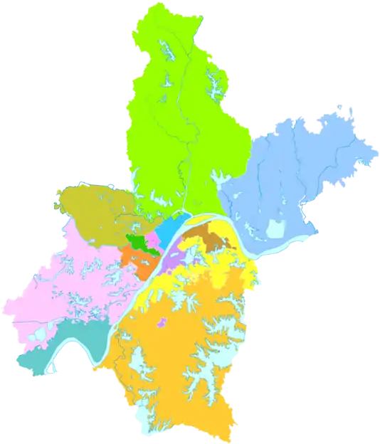
| Wuhan district map |
| |||||||||||||||||||||||||||||||||||
| Website | http://www.wedz.gov.cn/ | |||||||||||||||||||||||||||||||||||
Geography
Administrative Districts
In 2006, Dengnan Town (邓南镇) was made into Dengnan Subdistrict. Since this change, Hannan County has administered four subdistricts:[4][5][6][7]
| Name (with literal meaning) | Chinese (S) | Hanyu Pinyin |
|---|---|---|
| Shamao Subdistrict Black Gauze Cap | 纱帽街道 | Shāmào Jiēdào |
| Dongjing Subdistrict East Jing | 东荆街道 | Dōngjīng Jiēdào |
| Xiangkou Subdistrict Mouth of Xiang | 湘口街道 | Xiāngkǒu Jiēdào |
| Dengnan Subdistrict Deng South | 邓南街道 | Dèngnán Jiēdào |
Transportation
Line 3 (Wuhan Metro) starts from Zhuanyang Boulevard Station in the district.
References
- Google (2014-07-02). "Hannan" (Map). Google Maps. Google. Retrieved 2014-07-02.
- "Wuhan Statistical Yearbook 2010" (PDF). Wuhan Statistics Bureau. p. 15. Archived from the original (PDF) on November 5, 2011. Retrieved 2011-07-31.
- 武汉市2010年第六次全国人口普查主要数据公报 (in Chinese). Wuhan Statistics Bureau. 2011-05-11. Archived from the original on 2011-10-25. Retrieved 2011-06-11.
- 邓南街巧做“三个加法” 奏响现代农业发展新强音 [Three smart "additions" of Dengnan Subdistrict ring in a new strong sound on modern agricultural development] (in Chinese). Hannan District People's Government. 1 March 2017. Retrieved 17 December 2017.
汉南地区4个街道
- 汉南区历史沿革 [The Historical Development of Hannan District] (in Chinese). XZQH.org. 8 August 2014. Retrieved 17 December 2017.
2006年,撤销邓南镇,设立邓南街道。调整后,全区辖4个街道:纱帽街道、东荆街道、湘口街道、邓南街道。
- http://www.zgsxzs.com/a/20110919/19220.html
- 2017年统计用区划代码和城乡划分代码:汉南区 [2017 Statistical Area Numbers and Rural-Urban Area Numbers: Hannan District] (in Chinese). National Bureau of Statistics of the People's Republic of China. 2017. Retrieved 21 January 2019.
统计用区划代码 名称 420113001000 纱帽街道办事处 420113002000 邓南街道办事处 420113003000 东荆街道办事处 420113004000 湘口街道办事处
External links