Cumberland County, Pennsylvania
Cumberland County is a county located in the U.S. state of Pennsylvania. As of the 2010 census, the population was 235,406.[2] Its county seat is Carlisle.[3]
Cumberland County | |
|---|---|
.jpg.webp) Old Cumberland County Courthouse | |
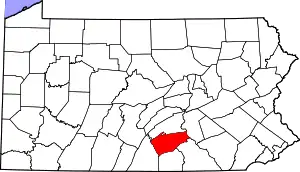 Location within the U.S. state of Pennsylvania | |
 Pennsylvania's location within the U.S. | |
| Coordinates: 40°10′N 77°16′W | |
| Country | |
| State | |
| Founded | January 27, 1750 |
| Named for | Cumberland |
| Seat | Carlisle |
| Largest borough | Carlisle |
| Area | |
| • Total | 550 sq mi (1,400 km2) |
| • Land | 545 sq mi (1,410 km2) |
| • Water | 4.8 sq mi (12 km2) 0.9%% |
| Population | |
| • Estimate (2019) | 253,370 |
| • Density | 457/sq mi (176/km2) |
| Time zone | UTC−5 (Eastern) |
| • Summer (DST) | UTC−4 (EDT) |
| Congressional districts | 10th, 13th |
| Website | www |
| Designated | May 17, 1982[1] |
Cumberland County is included in the Harrisburg-Carlisle, PA Metropolitan Statistical Area.
History
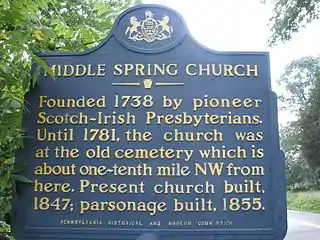
Cumberland County was first settled by a majority of Scots-Irish immigrants who arrived in this area about 1730. English and German settlers constituted about ten percent of the early population. The settlers originally mostly devoted the area to farming and later developed other trades.[4] These settlers built the Middle Spring Presbyterian Church, among the oldest houses of worship in central Pennsylvania, in 1738 near present-day Shippensburg, Pennsylvania.
The General Assembly (legislature) of the Pennsylvania colony on January 27, 1750, created Cumberland County from Lancaster County, Pennsylvania, naming it for Cumberland, England. Its county seat is Carlisle.[3] The county also lies within the Cumberland Valley adjoining the Susquehanna River at its eastern border, stretching approximately 42 miles from the borough of Shippensburg on the west to the Susquehanna River in east Cumberland County.
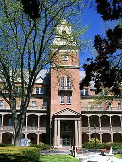
The oldest towns in the county are Shippensburg, Pennsylvania, and Carlisle, Pennsylvania, each with its unique history. Shippensburg is home to Shippensburg University of Pennsylvania, one of 14 universities of the Pennsylvania State System of Higher Education. Carlisle is also home to Dickinson College, established in 1773, and the Penn State Dickinson School of Law.
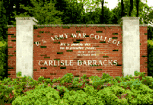
The United States Army War College is a United States Army school located in Carlisle, Pennsylvania, on the 500 acre (2 km2) campus of the historic Carlisle Barracks, a military post dating back to the 1770s. It caters to high-level military personnel and civilians and prepares them for strategic leadership responsibilities. It is the U. S. Army's most senior military educational institution.
During the Gettysburg campaign of the American Civil War in the summer of 1863, Confederate troops marched through the Cumberland Valley, briefly occupying much of Cumberland County.
In the 20th century, the suburbs of Harrisburg, Pennsylvania, the state capital, expanded extensively into eastern Cumberland County. Carlisle also developed suburbs in adjoining townships.
Geography
According to the U.S. Census Bureau, the county has a total area of 550 square miles (1,400 km2), of which 545 square miles (1,410 km2) is land and 4.8 square miles (12 km2) (0.9%) is water.[5] The area code is 717 with an overlay of 223. Blue Mountain forms Cumberland's northern natural boundary and Yellow Breeches Creek forms part of its SE natural boundary. The Susquehanna River drains the county and forms its eastern natural boundary. A large portion of Cumberland is drained by the Conodoguinet Creek, which winds its way west-to-east across the county into the Susquehanna.
Climate
Cumberland has a hot-summer humid continental climate (Dfa) and its hardiness zone is 6b except in much of the eastern portion where it is 7a. Average monthly temperatures in Lemoyne range from 29.9° F in January to 74.9° F in July, in Carlisle they range from 29.8° F in January to 75.2° F in July, and in Shippensburg they range from 29.6° F in January to 74.6° F in July.
Adjacent counties
- Perry County (north)
- Dauphin County (east)
- York County (southeast)
- Adams County (south)
- Franklin County (southwest)
Major highways
Demographics
| Historical population | |||
|---|---|---|---|
| Census | Pop. | %± | |
| 1790 | 18,208 | — | |
| 1800 | 25,386 | 39.4% | |
| 1810 | 26,757 | 5.4% | |
| 1820 | 23,606 | −11.8% | |
| 1830 | 29,226 | 23.8% | |
| 1840 | 30,953 | 5.9% | |
| 1850 | 34,327 | 10.9% | |
| 1860 | 40,098 | 16.8% | |
| 1870 | 43,912 | 9.5% | |
| 1880 | 45,977 | 4.7% | |
| 1890 | 47,271 | 2.8% | |
| 1900 | 50,344 | 6.5% | |
| 1910 | 54,479 | 8.2% | |
| 1920 | 58,578 | 7.5% | |
| 1930 | 68,236 | 16.5% | |
| 1940 | 74,806 | 9.6% | |
| 1950 | 94,457 | 26.3% | |
| 1960 | 124,816 | 32.1% | |
| 1970 | 158,177 | 26.7% | |
| 1980 | 178,541 | 12.9% | |
| 1990 | 195,257 | 9.4% | |
| 2000 | 213,670 | 9.4% | |
| 2010 | 235,406 | 10.2% | |
| 2019 (est.) | 253,370 | [6] | 7.6% |
| U.S. Decennial Census[7] 1790-1960[8] 1900-1990[9] 1990-2000[10] 2010-2019[2] | |||
As of the census[11] of 2000, there were 213,674 people, 83,015 households, and 56,118 families residing in the county. The population density was 388 people per square mile (150/km2). There were 86,951 housing units at an average density of 158 per square mile (61/km2). The racial makeup of the county was 94.40% White, 2.36% Black or African American, 0.13% Native American, 1.67% Asian, 0.04% Pacific Islander, 0.43% from other races, and 0.97% from two or more races. 1.35% of the population were Hispanic or Latino of any race. 35.3% were of German, 10.6% American, 10.1% Irish, 7.5% English and 6.8% Italian ancestry. 94.7% spoke English and 1.4% Spanish as their first language.
There were 83,015 households, out of which 29.50% had children under the age of 18 living with them, 56.50% were married couples living together, 8.00% had a female householder with no husband present, and 32.40% were non-families. 26.70% of all households were made up of individuals, and 10.30% had someone living alone who was 65 years of age or older. The average household size was 2.41 and the average family size was 2.92.
In the county, the population was spread out, with 22.00% under the age of 18, 10.60% from 18 to 24, 28.50% from 25 to 44, 24.10% from 45 to 64, and 14.90% who were 65 years of age or older. The median age was 38 years. For every 100 females, there were 95.20 males. For every 100 females age 18 and over, there were 92.70 males.
Its per capita income is $31,627, making it the wealthiest Pennsylvania county outside greater Philadelphia, and fifth wealthiest overall.
Metropolitan Statistical Area
The United States Office of Management and Budget[12] has designated Cumberland County as the Harrisburg-Carlisle, PA Metropolitan Statistical Area (MSA). As of the 2010 U.S. Census[13] the metropolitan area ranked 6th most populous in the State of Pennsylvania and the 96th most populous in the United States with a population of 549,475. Cumberland County is also a part of the larger Harrisburg-York-Lebanon, PA Combined Statistical Area (CSA), which combines the populations of Cumberland County as well as Adams, Dauphin, Lebanon, Perry and York Counties in Pennsylvania. The Combined Statistical Area ranked 5th in the State of Pennsylvania and 43rd most populous in the United States with a population of 1,219,422.
Government and politics
For most of its history, Cumberland County has been a Republican Party stronghold in presidential elections, with only seven Democratic Party candidates having managed to win the county from 1888 to the present day. The most recent Democrat to win the county in a presidential election was Lyndon B. Johnson in 1964 as he won in a landslide statewide & nationally. As a testament to the county's status as a Republican Party stronghold, Barack Obama in 2008 and Joe Biden in 2020 are the lone Democrats to win forty percent of the county's votes since Johnson's 1964 win.
| Year | Republican | Democratic | Third parties |
|---|---|---|---|
| 2020 | 54.3% 77,212 | 43.8% 62,245 | 1.9% 2,730 |
| 2016 | 55.9% 69,076 | 38.1% 47,085 | 5.9% 7,325 |
| 2012 | 58.3% 64,809 | 39.9% 44,367 | 1.8% 2,015 |
| 2008 | 56.0% 63,739 | 42.4% 48,306 | 1.6% 1,780 |
| 2004 | 63.8% 67,648 | 35.8% 37,928 | 0.5% 506 |
| 2000 | 62.2% 54,802 | 35.2% 31,053 | 2.6% 2,289 |
| 1996 | 55.6% 43,943 | 36.4% 28,749 | 8.0% 6,293 |
| 1992 | 51.4% 43,447 | 31.5% 26,635 | 17.1% 14,491 |
| 1988 | 65.3% 47,292 | 34.0% 24,613 | 0.7% 528 |
| 1984 | 69.3% 49,282 | 30.1% 21,374 | 0.7% 467 |
| 1980 | 61.2% 41,152 | 29.4% 19,789 | 9.4% 6,319 |
| 1976 | 62.2% 39,950 | 35.8% 23,008 | 2.0% 1,312 |
| 1972 | 72.9% 42,099 | 25.2% 14,562 | 1.9% 1,114 |
| 1968 | 61.5% 32,908 | 28.9% 15,467 | 9.5% 5,097 |
| 1964 | 46.9% 23,685 | 52.7% 26,633 | 0.4% 207 |
| 1960 | 68.8% 35,636 | 30.8% 15,968 | 0.4% 197 |
| 1956 | 68.1% 29,468 | 31.6% 13,651 | 0.4% 153 |
| 1952 | 67.2% 26,302 | 32.6% 12,762 | 0.2% 91 |
| 1948 | 60.7% 18,028 | 38.5% 11,421 | 0.8% 246 |
| 1944 | 59.3% 17,782 | 40.3% 12,068 | 0.5% 134 |
| 1940 | 49.2% 15,297 | 50.6% 15,758 | 0.2% 68 |
| 1936 | 43.8% 14,912 | 55.4% 18,850 | 0.8% 259 |
| 1932 | 50.9% 13,098 | 46.9% 12,086 | 2.2% 567 |
| 1928 | 78.1% 19,170 | 21.1% 5,189 | 0.8% 192 |
| 1924 | 53.2% 10,196 | 39.9% 7,643 | 6.9% 1,321 |
| 1920 | 54.7% 8,579 | 41.2% 6,455 | 4.1% 640 |
| 1916 | 43.0% 5,296 | 52.2% 6,432 | 4.9% 601 |
| 1912 | 21.9% 2,566 | 42.9% 5,023 | 35.2% 4,123 |
| 1908 | 51.4% 6,261 | 44.3% 5,403 | 4.3% 528 |
| 1904 | 56.7% 7,138 | 40.1% 5,038 | 3.2% 404 |
| 1900 | 49.1% 5,587 | 47.7% 5,428 | 3.3% 374 |
| 1896 | 52.3% 6,178 | 44.0% 5,202 | 3.7% 432 |
| 1892 | 44.1% 4,520 | 53.1% 5,446 | 2.9% 293 |
| 1888 | 45.4% 4,693 | 52.1% 5,386 | 2.6% 268 |
| 1884 | 45.7% 4,659 | 52.7% 5,375 | 1.4% 151 |
| 1880 | 44.1% 4,431 | 54.4% 5,462 | 1.3% 138 |
As of November 2008, there are 152,408 registered voters in Cumberland County.[15]
- Republican: 78,568 (51.55%)
- Democratic: 52,887 (34.70%)
- Other Parties: 20,953 (13.75%)
The Republican Party has been dominant in Cumberland County politics since before the American Civil War, with the victories of Robert P. Casey for governor in 1990, Bob Casey Jr. for state treasurer in 2004 and Tom Wolf for governor in 2018 being among the few times where a statewide Democrat carried the county. The county commissioner majority, all row offices, and all legislative seats serving Cumberland are held by Republicans.
County commissioners[16]
- Vince DiFilippo, Republican
- Jean Foschi, Democrat
- Gary Eichelberger, Chairman, Republican
Other county offices
- Clerk of Courts, Dennis Lebo, Republican
- Controller, Alfred Whitcomb, Republican
- Coroner Charles Hall, Republican
- District Attorney, M.L."Skip" Ebert, Republican
- Prothonotary, Dale Sabadish, Republican
- Recorder of Deeds, Tammy L. Shearer, Republican
- Register of Wills, Lisa M. Grayson, Esq., Republican
- Sheriff, R. Ron Anderson, Republican
- Treasurer, John Gross, Republican
State Representatives[17]
- Mark K. Keller, Republican, 86th district
- Greg Rothman, Republican, 87th district
- Sheryl M. Delozier, Republican, 88th district
- Dawn W. Keefer, Republican, 92nd district
- Torren C. Ecker Republican, 193rd district
- Barbara Gleim, Republican, 199th district
State Senator[17]
- Judy Ward, Republican, 30th district
- Mike Regan, Republican, 31st district
- Doug Mastriano, Republican, 33rd district
United States House of Representatives
- Scott Perry, Republican, 10th district
- John Joyce, Republican, 13th district
United States Senate
Education
Colleges and universities
- Central Pennsylvania College
- Dickinson College
- Messiah College
- Penn State Dickinson Law
- Shippensburg University of Pennsylvania
- U.S. Army War College
Community, junior and technical colleges
Public school districts
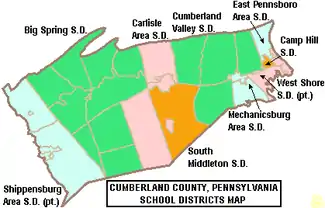
- Big Spring School District
- Camp Hill School District
- Carlisle Area School District
- Cumberland Valley School District
- East Pennsboro Area School District
- Mechanicsburg Area School District
- Shippensburg Area School District (also in Franklin County)
- South Middleton School District
- West Shore School District (also in York County)
Public charter schools
- Commonwealth Connections Academy Charter School - Mechanicsburg[18][19]
Technical school
- Cumberland-Perry Area Vocational Technical School
Head Start preschool programs
Head Start is a federally and state funded preschool program for low income children. The programs serve 3 and 4 year olds. In order to participate the family income must be below federal poverty guidelines.[20]
- Capital Area Head Start
- Shippensburg Head Start Program
PreK Counts schools
PreK Counts is a state funded preschool program for low income and middle class children aged 3–4 years old. Low income children attend for free. Middle class children receive a partial taxpayer funded subsidy, on a sliding scale which maxes out at $66,000. In accepting these grant dollars, the provider agrees to abide by state mandates. PreK Counts is run by the Pennsylvania Office of Early Learning and Child Development.
- Mechanicsburg Area School District
- Carlisle Early Education Center
- Knowledge Learning Corporation
Private schools
As reported by the National Center for Educational Statistics[21]
|
|
Communities
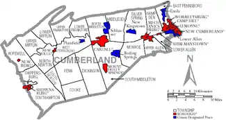
Under Pennsylvania law, there are four types of incorporated municipalities: cities, boroughs, townships, and, in at most two cases, towns. The following boroughs and townships are located in Cumberland County:
Boroughs
Townships
Census-designated places
Census-designated places are geographical areas designated by the U.S. Census Bureau for the purposes of compiling demographic data. They are not actual jurisdictions under Pennsylvania law. Other unincorporated communities, such as villages, may be listed here as well.
Unincorporated communities
Population ranking
The population ranking of the following table is based on the 2010 census of Cumberland County.[13]
† county seat
| Rank | City/Town/etc. | Municipal type | Population (2010 Census) |
|---|---|---|---|
| 1 | † Carlisle | Borough | 18,682 |
| 2 | Mechanicsburg | Borough | 8,981 |
| 3 | Camp Hill | Borough | 7,888 |
| 4 | New Cumberland | Borough | 7,277 |
| 5 | Lower Allen | CDP | 6,694 |
| 6 | Enola | CDP | 6,111 |
| 7 | Shippensburg (partially in Franklin County) | Borough | 5,492 |
| 8 | Schlusser | CDP | 5,265 |
| 9 | Lemoyne | Borough | 4,553 |
| 10 | Boiling Springs | CDP | 3,225 |
| 11 | Wormleysburg | Borough | 3,070 |
| 12 | Shippensburg University | CDP | 2,625 |
| 13 | Messiah College | CDP | 2,215 |
| 14 | Mount Holly Springs | Borough | 2,030 |
| 15 | Shiremanstown | Borough | 1,569 |
| 16 | Newville | Borough | 1,326 |
| 17 | West Fairview | CDP | 1,282 |
| 18 | New Kingstown | CDP | 495 |
| 19 | Plainfield | CDP | 399 |
| 20 | Newburg | Borough | 336 |
References
- "PHMC Historical Markers Search" (Searchable database). Pennsylvania Historical and Museum Commission. Commonwealth of Pennsylvania. Retrieved January 25, 2014.
- "State & County QuickFacts". United States Census Bureau. Archived from the original on February 21, 2016. Retrieved November 16, 2013.
- "Find a County". National Association of Counties. Archived from the original on May 31, 2011. Retrieved June 7, 2011.
- Wayland F. Dunaway, The Scotch-Irish of Colonial Pennsylvania; University of North Carolina Press, 1944, p. 60.
- "2010 Census Gazetteer Files". United States Census Bureau. August 22, 2012. Retrieved March 6, 2015.
- "Population and Housing Unit Estimates". Retrieved March 26, 2020.
- "U.S. Decennial Census". United States Census Bureau. Retrieved March 6, 2015.
- "Historical Census Browser". University of Virginia Library. Retrieved March 6, 2015.
- Forstall, Richard L., ed. (March 24, 1995). "Population of Counties by Decennial Census: 1900 to 1990". United States Census Bureau. Retrieved March 6, 2015.
- "Census 2000 PHC-T-4. Ranking Tables for Counties: 1990 and 2000" (PDF). United States Census Bureau. April 2, 2001. Retrieved March 6, 2015.
- "U.S. Census website". United States Census Bureau. Retrieved 2008-01-31.
- "Office of Management and Budget". whitehouse.gov. Retrieved 4 April 2018.
- "2010 U.S. Census website". United States Census Bureau. Retrieved 2015-12-06.
- Leip, David. "Dave Leip's Atlas of U.S. Presidential Elections". uselectionatlas.org. Retrieved 4 April 2018.
- Running for Office Archived 2008-11-26 at the Wayback Machine. Dos.state.pa.us. Retrieved on 2013-07-23.
- "Meet the Commissioners | Cumberland County, PA - Official Website". www.ccpa.net. Retrieved 2017-04-19.
- Center, Legislativate Data Processing. "Find Your Legislator". The official website for the Pennsylvania General Assembly. Retrieved 2017-04-21.
- Palleschi, Amanda. Enrollment in cyber charter schools booming in Pennsylvania despite friction with school districts, The Patriot News, November 30, 2009
- Pennsylvania Department of Education - Operating Charter Schools in Pennsylvania Report. September 2009.
- 2009-Cumberland County Report Card Early Childhood Education. United Way of Carlisle and Cumberland County. June 2009
- ies, National Center for Education Statistics, US Department of Education, Institute of Education Sciences, Private School Universe Survey 2008
External links
| Wikimedia Commons has media related to Cumberland County, Pennsylvania. |
- County of Cumberland (official website)
- Cumberland Area Economic Development Corporation
- Carlisle Young Professionals
- Cumberland Valley Visitors Bureau
Municipalities and communities of Cumberland County, Pennsylvania, United States | ||
|---|---|---|
| Boroughs | | |
| Townships | ||
| CDPs | ||
| Unincorporated communities | ||
| Footnotes | ‡This populated place also has portions in an adjacent county or counties | |
| ||

| Authority control |
|---|