Hartville, Ohio
Hartville is a village in Stark County, Ohio, United States. The population was 2,944 at the 2010 census. It is part of the Canton-Massillon, OH Metropolitan Statistical Area.

Hartville, Ohio | |
|---|---|
Historic Downtown Hartville, Ohio | |
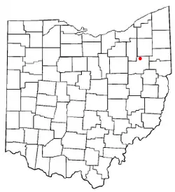 Location of Hartville, Ohio | |
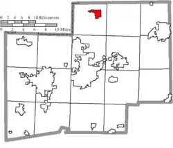 Location of Hartville in Stark County | |
| Coordinates: 40°57′44″N 81°20′23″W | |
| Country | United States |
| State | Ohio |
| County | Stark |
| Township | Lake |
| Area | |
| • Total | 2.70 sq mi (6.99 km2) |
| • Land | 2.70 sq mi (6.98 km2) |
| • Water | 0.00 sq mi (0.00 km2) |
| Elevation | 1,168 ft (356 m) |
| Population | |
| • Total | 2,944 |
| • Estimate (2019)[4] | 3,079 |
| • Density | 1,142.06/sq mi (440.91/km2) |
| Time zone | UTC-5 (Eastern (EST)) |
| • Summer (DST) | UTC-4 (EDT) |
| ZIP code | 44632 |
| Area code(s) | 330 |
| FIPS code | 39-34328[5] |
| GNIS feature ID | 1064808[2] |
| Website | www |
Hartville lies halfway between Akron and Canton, at the intersection of two main roads, State Routes 43 and 619.
Geography
Hartville is located at 40°57′44″N 81°20′23″W (40.962207, -81.339822).[6]
According to the United States Census Bureau, the village has a total area of 2.58 square miles (6.68 km2), all land.[7]
History
Hartville was platted in 1851, most likely deriving its name from John Morehart, a first settler.[8]
Notable people
- Aaron Brumbaugh, president of Shimer College
- Andrew Wellington Cordier, a United Nations official and President of Columbia University
Demographics
| Historical population | |||
|---|---|---|---|
| Census | Pop. | %± | |
| 1880 | 135 | — | |
| 1960 | 1,353 | — | |
| 1970 | 1,752 | 29.5% | |
| 1980 | 1,772 | 1.1% | |
| 1990 | 2,031 | 14.6% | |
| 2000 | 2,174 | 7.0% | |
| 2010 | 2,944 | 35.4% | |
| 2019 (est.) | 3,079 | [4] | 4.6% |
| U.S. Decennial Census[9] | |||
2010 census
As of the census[3] of 2010, there were 2,944 people, 1,154 households, and 806 families living in the village. The population density was 1,141.1 inhabitants per square mile (440.6/km2). There were 1,276 housing units at an average density of 494.6 per square mile (191.0/km2). The racial makeup of the village was 96.1% White, 0.8% African American, 0.1% Native American, 0.7% Asian, 0.5% from other races, and 1.9% from two or more races. Hispanic or Latino of any race were 1.0% of the population.
There were 1,154 households, of which 36.0% had children under the age of 18 living with them, 51.4% were married couples living together, 14.3% had a female householder with no husband present, 4.2% had a male householder with no wife present, and 30.2% were non-families. 26.5% of all households were made up of individuals, and 11.6% had someone living alone who was 65 years of age or older. The average household size was 2.52 and the average family size was 3.06.
The median age in the village was 38 years. 26.8% of residents were under the age of 18; 9.2% were between the ages of 18 and 24; 24% were from 25 to 44; 25.6% were from 45 to 64; and 14.5% were 65 years of age or older. The gender makeup of the village was 47.2% male and 52.8% female.
2000 census
As of the census[5] of 2000, there were 2,174 people, 863 households, and 579 families living in the village. The population density was 1,186.2 people per square mile (458.7/km2). There were 902 housing units at an average density of 492.2 per square mile (190.3/km2). The racial makeup of the village was 98.39% White, 0.28% African American, 0.18% Native American, 0.18% Asian, 0.05% Pacific Islander, 0.28% from other races, and 0.64% from two or more races. Hispanic or Latino of any race were 0.83% of the population.
There were 863 households, out of which 33.6% had children under the age of 18 living with them, 52.1% were married couples living together, 12.3% had a female householder with no husband present, and 32.9% were non-families. 28.0% of all households were made up of individuals, and 8.3% had someone living alone who was 65 years of age or older. The average household size was 2.49 and the average family size was 3.09.
In the village, the population was spread out, with 26.9% under the age of 18, 10.1% from 18 to 24, 32.4% from 25 to 44, 19.6% from 45 to 64, and 11.0% who were 65 years of age or older. The median age was 34 years. For every 100 females there were 95.9 males. For every 100 females age 18 and over, there were 91.3 males.
The median income for a household in the village was $41,012, and the median income for a family was $47,411. Males had a median income of $34,821 versus $22,679 for females. The per capita income for the village was $19,362. About 6.2% of families and 9.2% of the population were below the poverty line, including 12.7% of those under age 18 and 4.9% of those age 65 or over.
References
- "2019 U.S. Gazetteer Files". United States Census Bureau. Retrieved July 28, 2020.
- "US Board on Geographic Names". United States Geological Survey. 2007-10-25. Retrieved 2008-01-31.
- "U.S. Census website". United States Census Bureau. Retrieved 2013-01-06.
- "Population and Housing Unit Estimates". United States Census Bureau. May 24, 2020. Retrieved May 27, 2020.
- "U.S. Census website". United States Census Bureau. Retrieved 2008-01-31.
- "US Gazetteer files: 2010, 2000, and 1990". United States Census Bureau. 2011-02-12. Retrieved 2011-04-23.
- "US Gazetteer files 2010". United States Census Bureau. Retrieved 2013-01-06.
- Overman, William Daniel (1958). Ohio Town Names. Akron, OH: Atlantic Press. p. 58.
- "Census of Population and Housing". Census.gov. Retrieved June 4, 2015.
External links
Municipalities and communities of Stark County, Ohio, United States | ||
|---|---|---|
| Cities |  Map of Ohio highlighting Stark County | |
| Villages | ||
| Townships | ||
| CDPs | ||
| Unincorporated communities | ||
| Footnotes | ‡This populated place also has portions in an adjacent county or counties | |
| ||