Sugar Creek Township, Stark County, Ohio
Sugar Creek Township is one of the seventeen townships of Stark County, Ohio, United States. The 2000 census found 2,944 people in the township.[3]
Sugar Creek Township | |
|---|---|
.JPG.webp) Emanuel and Frederick Serquet Farmhouse | |
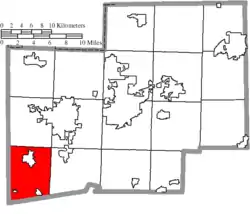 Location of Sugar Creek Township in Stark County | |
| Coordinates: 40°41′22″N 81°35′32″W | |
| Country | United States |
| State | Ohio |
| County | Stark |
| Area | |
| • Total | 33.9 sq mi (87.9 km2) |
| • Land | 33.9 sq mi (87.7 km2) |
| • Water | 0.1 sq mi (0.2 km2) |
| Elevation | 978 ft (298 m) |
| Population (2000)- The "Historical Population" box located elsewhere on this page includes residents of villages within the Township, so it does not represent the true number of actual Township residents. | |
| • Total | 2,944 |
| • Density | 86.8/sq mi (33.5/km2) |
| Time zone | UTC-5 (Eastern (EST)) |
| • Summer (DST) | UTC-4 (EDT) |
| Zip code | 44662, 44613 |
| Area code(s) | 330 |
| FIPS code | 39-75208[2] |
| GNIS feature ID | 1086990[1] |
Geography
Located in the southwestern corner of the county, it borders the following townships:
- Tuscarawas Township - north
- Perry Township - northeast corner
- Bethlehem Township - east
- Franklin Township, Tuscarawas County - southeast
- Wayne Township, Tuscarawas County - south
- Paint Township, Holmes County - southwest
- Paint Township, Wayne County - west
- Sugar Creek Township, Wayne County - northwest
The most southerly township in the county, it is the only township in the county that borders Holmes County.
Three villages are located in Sugar Creek Township:
- Beach City in the southeast
- Brewster in the north
- Wilmot in the southwest
Name and history
| Historical population | |||
|---|---|---|---|
| Census | Pop. | %± | |
| 1820 | 492 | — | |
| 1830 | 1,263 | 156.7% | |
| 1840 | 1,862 | 47.4% | |
| 1850 | 1,743 | −6.4% | |
| 1860 | 1,800 | 3.3% | |
| 1870 | 1,779 | −1.2% | |
| 1880 | 2,285 | 28.4% | |
| 1890 | 2,782 | 21.8% | |
| 1900 | 2,554 | −8.2% | |
| 1910 | 3,073 | 20.3% | |
| 1920 | 3,821 | 24.3% | |
| 1930 | 4,425 | 15.8% | |
| 1940 | 4,681 | 5.8% | |
| 1950 | 5,056 | 8.0% | |
| 1960 | 5,802 | 14.8% | |
| 1970 | 6,132 | 5.7% | |
| 1990 | 6,489 | — | |
| 2000 | 6,740 | 3.9% | |
| [4] | |||
Named for its Sugar Creek,[5] it is one of five Sugar Creek Townships statewide.[6]
Government
The township is governed by a three-member board of trustees, who are elected in November of odd-numbered years to a four-year term beginning on the following January 1. Two are elected in the year after the presidential election and one is elected in the year before it. There is also an elected township fiscal officer,[7] who serves a four-year term beginning on April 1 of the year after the election, which is held in November of the year before the presidential election. Vacancies in the fiscal officership or on the board of trustees are filled by the remaining trustees.
References
- "US Board on Geographic Names". United States Geological Survey. 2007-10-25. Retrieved 2008-01-31.
- "U.S. Census website". United States Census Bureau. Retrieved 2008-01-31.
- Stark County, Ohio — Population by Places Estimates Ohio State University, 2007. Accessed 15 May 2007.
- census data: 1820 : 1820 page 137, 1830 : Kilbourn, John (1831). The Ohio gazetteer: or, Topographical dictionary: describing the several ... in the State of Ohio. self. p. 332., 1840, 1880 : Howe, Henry (1907). Historical Collections of Ohio, The Ohio Centennial Edition. The State of Ohio. p. 285., 1850, 1860, 1870 : 1870 page 35, 1890, 1900 : Hunt, William C. (1901). Population of the United States by states and territories, counties, and minor Civil Divisions, as returned at the Twelfth Census: 1900. United States Census Printing Office. p. 318., 1910, 1920, 1930 : 1930 page 56, 1940, 1950 : 1950 page 21, 1960, 1970 : 1970 page 135, 1990 : 1990 , 2000 : 2000
- Lehman, John H. (1916). A Standard History of Stark County, Ohio: An Authentic Narrative of the Past, with Particular Attention to the Modern Era in the Commercial, Industrial, Civic and Social Development. Lewis Publishing Company. p. 75.
- "Detailed map of Ohio" (PDF). United States Census Bureau. 2000. Retrieved 2007-02-16.
- §503.24, §505.01, and §507.01 of the Ohio Revised Code. Accessed 4/30/2009.
External links
Municipalities and communities of Stark County, Ohio, United States | ||
|---|---|---|
| Cities | 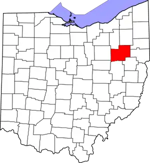 Map of Ohio highlighting Stark County | |
| Villages | ||
| Townships | ||
| CDPs | ||
| Unincorporated communities | ||
| Footnotes | ‡This populated place also has portions in an adjacent county or counties | |
| ||