Limaville, Ohio
Limaville is a census-designated place (CDP) and former village[6] in Stark County, Ohio, United States. The population was 151 at the 2010 census. It is part of the Canton–Massillon Metropolitan Statistical Area.
Limaville, Ohio | |
|---|---|
 Limaville Post Office | |
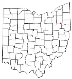 Location of Limaville, Ohio | |
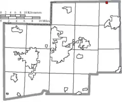 Location of Limaville in Stark County | |
| Coordinates: 40°58′57″N 81°8′49″W | |
| Country | United States |
| State | Ohio |
| County | Stark |
| Township | Lexington |
| Area | |
| • Total | 0.28 sq mi (0.73 km2) |
| • Land | 0.27 sq mi (0.70 km2) |
| • Water | 0.01 sq mi (0.03 km2) |
| Elevation | 1,060 ft (323 m) |
| Population | |
| • Total | 151 |
| • Estimate (2019[4]) | 144 |
| • Density | 559.3/sq mi (215.9/km2) |
| Time zone | UTC-5 (Eastern (EST)) |
| • Summer (DST) | UTC-4 (EDT) |
| ZIP code | 44640 |
| Area code(s) | 330 |
| FIPS code | 39-43596[5] |
| GNIS feature ID | 1064996[2] |
Geography
Limaville is located at 40°58′57″N 81°8′49″W (40.982458, -81.146820).[7]
According to the United States Census Bureau, the village has a total area of 0.28 square miles (0.73 km2), of which 0.27 square miles (0.70 km2) is land and 0.01 square miles (0.03 km2) is water.[1]
Demographics
| Historical population | |||
|---|---|---|---|
| Census | Pop. | %± | |
| 1870 | 204 | — | |
| 1880 | 164 | −19.6% | |
| 1890 | 172 | 4.9% | |
| 1900 | 156 | −9.3% | |
| 1910 | 136 | −12.8% | |
| 1920 | 183 | 34.6% | |
| 1930 | 195 | 6.6% | |
| 1940 | 209 | 7.2% | |
| 1950 | 209 | 0.0% | |
| 1960 | 226 | 8.1% | |
| 1970 | 303 | 34.1% | |
| 1980 | 164 | −45.9% | |
| 1990 | 152 | −7.3% | |
| 2000 | 193 | 27.0% | |
| 2010 | 151 | −21.8% | |
| 2019 (est.) | 144 | [8] | −4.6% |
| U.S. Decennial Census[9] | |||
2010 census
As of the census[3] of 2010, there were 151 people, 60 households, and 44 families living in the village. The population density was 559.3 inhabitants per square mile (215.9/km2). There were 65 housing units at an average density of 240.7 per square mile (92.9/km2). The racial makeup of the village was 98.0% White and 2.0% African American. Hispanic or Latino of any race were 0.7% of the population.
There were 60 households, of which 35.0% had children under the age of 18 living with them, 53.3% were married couples living together, 10.0% had a female householder with no husband present, 10.0% had a male householder with no wife present, and 26.7% were non-families. 25.0% of all households were made up of individuals, and 13.4% had someone living alone who was 65 years of age or older. The average household size was 2.52 and the average family size was 2.86.
The median age in the village was 42.2 years. 25.8% of residents were under the age of 18; 6.5% were between the ages of 18 and 24; 22.5% were from 25 to 44; 24.6% were from 45 to 64; and 20.5% were 65 years of age or older. The gender makeup of the village was 52.3% male and 47.7% female.
2000 census
As of the census[5] of 2000, there were 193 people, 71 households, and 59 families living in the village. The population density was 707.4 people per square mile (276.0/km2). There were 74 housing units at an average density of 271.2 per square mile (105.8/km2). The racial makeup of the village was 97.41% White, 0.52% Native American, 1.55% from other races, and 0.52% from two or more races. Hispanic or Latino of any race were 3.63% of the population.
There were 71 households, out of which 39.4% had children under the age of 18 living with them, 64.8% were married couples living together, 14.1% had a female householder with no husband present, and 15.5% were non-families. 11.3% of all households were made up of individuals, and 2.8% had someone living alone who was 65 years of age or older. The average household size was 2.72 and the average family size was 2.88.
In the village, the population was spread out, with 24.9% under the age of 18, 8.3% from 18 to 24, 29.5% from 25 to 44, 22.3% from 45 to 64, and 15.0% who were 65 years of age or older. The median age was 38 years. For every 100 females there were 112.1 males. For every 100 females age 18 and over, there were 113.2 males.
The median income for a household in the village was $37,750, and the median income for a family was $37,083. Males had a median income of $21,875 versus $23,125 for females. The per capita income for the village was $15,026. About 10.6% of families and 8.5% of the population were below the poverty line, including 14.0% of those under the age of eighteen and 10.0% of those 65 or over.
References
- "US Gazetteer files 2010". United States Census Bureau. Archived from the original on 2012-07-02. Retrieved 2013-01-06.
- "US Board on Geographic Names". United States Geological Survey. 2007-10-25. Retrieved 2008-01-31.
- "U.S. Census website". United States Census Bureau. Retrieved 2013-01-06.
- "Population and Housing Unit Estimates". Retrieved May 21, 2020.
- "U.S. Census website". United States Census Bureau. Retrieved 2008-01-31.
- Hall, Malcolm (2018-05-23). "Officials in Limaville preparing to dissolve village". The Repository. Canton, Ohio. Retrieved 2020-09-03.
- "US Gazetteer files: 2010, 2000, and 1990". United States Census Bureau. 2011-02-12. Retrieved 2011-04-23.
- "Population and Housing Unit Estimates". United States Census Bureau. May 24, 2020. Retrieved May 27, 2020.
- "Census of Population and Housing". Census.gov. Retrieved June 4, 2015.
Municipalities and communities of Stark County, Ohio, United States | ||
|---|---|---|
| Cities | 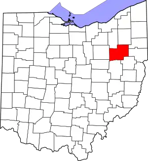 Map of Ohio highlighting Stark County | |
| Villages | ||
| Townships | ||
| CDPs | ||
| Unincorporated communities | ||
| Footnotes | ‡This populated place also has portions in an adjacent county or counties | |
| ||