Heidelberg, Minnesota
Heidelberg is a city in Le Sueur County, Minnesota, United States. The population was 122 at the 2010 census.[6]
Heidelberg, Minnesota | |
|---|---|
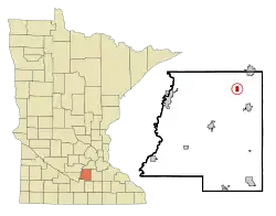 Location of Heidelberg, Minnesota | |
| Coordinates: 44°30′N 93°37′W | |
| Country | United States |
| State | Minnesota |
| County | Le Sueur |
| Area | |
| • Total | 0.53 sq mi (1.38 km2) |
| • Land | 0.53 sq mi (1.38 km2) |
| • Water | 0.00 sq mi (0.00 km2) |
| Elevation | 1,053 ft (321 m) |
| Population | |
| • Total | 122 |
| • Estimate (2019)[3] | 124 |
| • Density | 233.08/sq mi (90.01/km2) |
| Time zone | UTC-6 (Central (CST)) |
| • Summer (DST) | UTC-5 (CDT) |
| FIPS code | 27-28214[4] |
| GNIS feature ID | 0644839[5] |
| Website | cityofheidelbergmn |
Geography
According to the United States Census Bureau, the city has a total area of 0.53 square miles (1.37 km2), all of it land.[7]
County Highway 28 serves as a main route in the community. Minnesota State Highway 13 is nearby.
History
Heidelberg was platted in 1878, and named by its original German settlers (Frank Heil and Frederick Ihrig) after Heidelberg, in Germany.[8] A post office operated in the community from 1872 until 1903.[9] Heidelberg was incorporated in 1894.[8]
Demographics
| Historical population | |||
|---|---|---|---|
| Census | Pop. | %± | |
| 1900 | 114 | — | |
| 1910 | 111 | −2.6% | |
| 1920 | 73 | −34.2% | |
| 1930 | 56 | −23.3% | |
| 1940 | 71 | 26.8% | |
| 1950 | 61 | −14.1% | |
| 1960 | 44 | −27.9% | |
| 1970 | 72 | 63.6% | |
| 1980 | 102 | 41.7% | |
| 1990 | 73 | −28.4% | |
| 2000 | 72 | −1.4% | |
| 2010 | 122 | 69.4% | |
| 2019 (est.) | 124 | [3] | 1.6% |
| U.S. Decennial Census[10] | |||
The median income for a household in the city as of 2009 was $69,686. The per capita income for the city was $25,398. None of the population or the families were below the poverty line.
2010 census
As of the census[2] of 2010, there were 122 people, 41 households, and 34 families residing in the city. The population density was 230.2 inhabitants per square mile (88.9/km2). There were 47 housing units at an average density of 88.7 per square mile (34.2/km2). The racial makeup of the city was 100.0% White. Hispanic or Latino of any race were 1.6% of the population.
There were 41 households, of which 51.2% had children under the age of 18 living with them, 75.6% were married couples living together, 4.9% had a female householder with no husband present, 2.4% had a male householder with no wife present, and 17.1% were non-families. 12.2% of all households were made up of individuals, and 4.9% had someone living alone who was 65 years of age or older. The average household size was 2.98 and the average family size was 3.32.
The median age in the city was 40.3 years. 33.6% of residents were under the age of 18; 2.4% were between the ages of 18 and 24; 27.9% were from 25 to 44; 25.4% were from 45 to 64; and 10.7% were 65 years of age or older. The gender makeup of the city was 55.7% male and 44.3% female.
References
- "2019 U.S. Gazetteer Files". United States Census Bureau. Retrieved July 26, 2020.
- "U.S. Census website". United States Census Bureau. Retrieved 2012-11-13.
- "Population and Housing Unit Estimates". United States Census Bureau. May 24, 2020. Retrieved May 27, 2020.
- "U.S. Census website". United States Census Bureau. Retrieved 2008-01-31.
- "US Board on Geographic Names". United States Geological Survey. 2007-10-25. Retrieved 2008-01-31.
- "2010 Census Redistricting Data (Public Law 94-171) Summary File". American FactFinder. United States Census Bureau. Retrieved 27 April 2011.
- "US Gazetteer files 2010". United States Census Bureau. Archived from the original on 2012-01-25. Retrieved 2012-11-13.
- Upham, Warren (1920). Minnesota Geographic Names: Their Origin and Historic Significance. Minnesota Historical Society. p. 301.
- "Le Sueur County County". Jim Forte Postal History. Retrieved 18 July 2015.
- "Census of Population and Housing". Census.gov. Retrieved June 4, 2015.
External links
Municipalities and communities of Le Sueur County, Minnesota, United States | ||
|---|---|---|
| Cities |  Map of Minnesota highlighting Le Sueur County | |
| Townships | ||
| Unincorporated communities | ||
| Footnotes | ‡This populated place also has portions in an adjacent county or counties | |
| ||
