Hundreds of Norfolk

Between the Anglo-Saxon period and the 19th century, the hundreds of Norfolk and the boroughs of Norwich, King's Lynn, Thetford and Great Yarmouth were the administrative units of the English county of Norfolk. Each hundred had a separate council that met each month to rule on local judicial and taxation matters.

Map of the hundreds of Norfolk

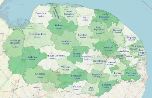
The English shire system was not definitely established in East Anglia before the Norman Conquest, but the boundaries at the time of the Domesday Survey of 1086 remained largely unchanged up to the 1970s. The 36 Domesday hundreds were subdivided into leets, now lost, and the boroughs of Norwich and Thetford ranked as separate hundreds, while Great Yarmouth was the chief town of three hundreds. Two of Thetford's parishes now lie partially in Norfolk with the remainder in Suffolk. The Domesday hundred of Emneth is now included in Freebridge, which was split into Freebridge-Lynn and Freebridge-Marshland. Docking hundred was then incorporated into Smithdon, and the boundary between Brothercross and Gallow hundreds was changed.[1] By the 19th century there were 33 hundreds.

The leet court boundaries were more fluid and transient than the hundred court boundaries. At the time of Domesday, the parishes of the hundreds of Brothercross and Gallow "were strangely intermixed".[2]

Sites of hundred courts

The hundred courts were held at various sites across the county:[1]

Name of hundredSite of hundred court
BrothercrossAt the cross by the ford over the Burnham
ClackcloseClackclose Hill on Stradsett common
DepwadeAt the "deep ford" over the Tas
EarshamAt an encampment near Earsham church.
EynsfordReepham
ForehoeParish of Carleton Forehoe
FreebridgeAt Flitcham Burgh, afterwards at an oak at Gaywood and still later at an oak at Wiggenhall St Germans
GallowIn the 15th century at Fakenham and in the 16th century at Longfield Stone
GreenhoeBy the tumuli on the London road to Swaffham
GrimeshoeAt a tumulus between Brandon and Norwich
HumbleyardParish of Swardeston
LaunditchAt the crossing of the Norwich road with the long ditch between Longham and Beeston
MitfordIn 1639, at "Brokpit"
North ErpinghamAt Guneby Gate near Gunton
SmithdonParish of Bircham Magna
South ErpinghamAt Cawston Park Gate
TaverhamFrettenham Hill

Parishes

In 1845 the hundreds of Norfolk contained the following parishes.[3]

Hundred Area Parishes
Blofield19,666 acres (79.59 km2)Blofield, Braydeston, Brundall, Buckenham, Cantley, Freethorpe, Great Plumstead, Hassingham, Limpenhoe, Lingwood, Little Plumstead, North Burlingham, Postwick, South Burlingham, Southwood, Strumpshaw, Thorpe, Witton
Brothercross19,169 acres (77.57 km2)Burnham Deepdale, Burnham Sutton and Burnham Ulph, Burnham Norton, Burnham Overy, Burnham Thorpe, Burnham Westgate, North Creake, South Creake, Waterden
Clackclose84,333 acres (341.28 km2)Barton Bendish, Beachamwell, Bexwell, Boughton, Crimplesham, Denver, Downham Market, Fincham, Fordham, Hilgay, Holme next Runcton, Marham, Outwell, Roxham, Ryston, Shingham, Shouldham, Shouldham Thorpe, South Runcton, Southery, Stoke Ferry, Stow Bardolph, Stradsett, Thorpland, Tottenhill, Upwell, Watlington, Welney, Wereham, West Dereham, Wimbotsham, Wormegay, Wretton
Clavering29,844 acres (120.77 km2)Aldeby, Bergh Apton, Brooke, Burgh St. Peter, Ellingham, Geldeston, Gillingham All Saints and St. Mary, Haddiscoe, Hales, Heckingham, Howe, Kirby Cane, Norton Subcourse, Raveningham, Stockton, Thorpe, Thurlton, Toft Monks, Wheatacre
Depwade30,491 acres (123.39 km2)Ashwellthorpe, Aslacton, Bunwell, Carleton Rode, Forncett St Mary, Forncett St Peter, Fritton, Fundenhall, Great Moulton, Hapton, Hardwick, Hempnall, Morningthorpe, Shelton, Stratton St. Mary, Stratton St. Michael, Tacolneston, Tasburgh, Tharston, Tibenham, Wacton
Diss23,628 acres (95.62 km2)Bressingham, Burston, Dickleburgh, Diss, Fersfield, Frenze, Gissing, Roydon, Scole, Shelfanger, Shimpling, Thelveton, Thorpe Parva, Tivetshall St. Margaret, Tivetshall St. Mary, Winfarthing
Earsham24,564 acres (99.41 km2)Alburgh, Billingford, Brockdish, Denton, Earsham, Mendham, Needham, Pulham Market, Pulham St Mary, Redenhall with Harleston, Rushall, Starston, Thorpe Abbotts, Wortwell
East Flegg11,556 acres (46.77 km2)Caister, Filby, Great Yarmouth, Mautby, Ormesby St. Margaret, Ormesby St. Michael, Runham, Scratby, Stokesby with Herringby, Thrigby
Eynesford46,637 acres (188.73 km2)Alderford, Bawdeswell, Billingford, Bintree, Brandiston, Bylaugh, Elsing, Foulsham, Foxley, Great Witchingham, Guestwick, Guist, Hackford, Haveringland, Hindolveston, Little Witchingham, Lyng, Morton-on-the-Hill, Reepham, Ringland, Salle, Sparham, Swannington, Themelthorpe, Thurning, Twyford, Weston Longville, Whitwell, Wood Dalling, Wood Norton
Forehoe39,042 acres (158.00 km2)Barford, Barnham Broom, Bawburgh, Bowthorpe, Brandon Parva, Carleton Forehoe, Colton, Costessey, Coston, Crownthorpe, Deopham, Easton, Hackford, Hingham, Honingham, Kimberley, Marlingford, Morley St. Botolph, Morley St. Peter, Runhall, Welborne, Wicklewood, Wramplingham, Wymondham
Freebridge-Lynn68,366 acres (276.67 km2)Anmer, Ashwicken, Babingley, Bawsey, Castle Acre, Castle Rising, Congham, Dersingham, East Walton, East Winch, Flitcham, Gayton, Gayton Thorpe, Gaywood, Great Massingham, Grimstone, Harpley, Hillington, King's Lynn, Leziate, Little Massingham, Middleton, Mintlyn, North Runcton, North Wootton, Pentney, Roydon, Sandringham, Setchey, South Wootton, West Acre, West Bilney, West Newton, West Winch, Wolferton
Freebridge-Marshland53,908 acres (218.16 km2)Clenchwarton, Emneth, St Edmund, St. Peter, Terrington St. Clement, Terrington St. John, Tilney All Saints, Tilney St. Lawrence, Tilney cum Islington, Walpole St. Andrew, Walpole St. Peter, Walsoken, Walton, Wiggenhall St. Germans, Wiggenhall St. Mary Magdalen, Wiggenhall St. Mary the Virgin, Wiggenhall St. Peter
Gallow42,480 acres (171.9 km2)Alethorpe, Bagthorpe, Barmer, Broomsthorpe, Dunton, East Barsham, East Raynham, East Rudham, Fakenham, Fulmodeston, Great Ryburgh, Helhoughton, Hempton, Kettlestone, Little Ryburgh, Little Snoring, New Houghton, North Barsham, Pensthorpe, Pudding Norton, Sculthorpe, Shereford, South Raynham, Stibbard, Syderstone, Tatterford, Tattersett, Testerton, Toftrees, West Barsham, West Raynham, West Rudham
Grimshoe57,309 acres (231.92 km2)Buckenham Tofts, Colveston, Cranwich, Croxton, Feltwell, Hockwold cum Wilton, Igborough, Lynford, Methwold, Mundford, Northwold, Santon, Stanford, Sturston, Weeting All Saints, West Tofts
Guiltcross26,828 acres (108.57 km2)Banham, Blo' Norton, East Harling, Garboldisham, Gasthorpe, Kenninghall, North Lopham, Quidenham, Riddlesworth, Rushford, Snarehill, South Lopham, West Harling
Happing26,780 acres (108.4 km2)Brumstead, Catfield, East Ruston, Happisburgh, Hempstead, Hickling, Horsey, Ingham, Lessingham, Ludham, Sea Palling, Potter Heigham, Stalham, Sutton, Walcott, Waxham
Henstead19,086 acres (77.24 km2)Arminghall, Bixley, Bramerton, Caistor St Edmund, Framingham Earl, Framingham Pigot, Holverstone, Kirby Bedon, Poringland, Rockland St. Mary, Saxlingham Nethergate, Saxlingham Thorpe, Shottesham All Saints, Shotesham, Stoke Holy Cross, Surlingham, Trowse, Whitlingham, Yelverton
Holt35,294 acres (142.83 km2)Bale, Bayfield, Blakeney, Bodham, Briningham, Brinton, Briston, Cley-next-the-Sea, Edgefield, Glandford, Gunthorpe, Hempstead, Holt, Hunworth, Kelling, Langham, Letheringsett, Melton Constable, Morston, Salthouse, Saxlingham, Sharrington, Stody, Swanton Novers, Thornage, Weybourne, Wiveton
Humbleyard21,355 acres (86.42 km2)Bracon Ash, Colney, Cringleford, Dunston, East Carlton, Flordon, Great Melton, Hethel, Hethersett, Intwood, Keswick, Ketteringham, Little Melton, Markshall, Mulbarton, Newton Flotman, Swainsthorpe, Swardeston, Wreningham
Launditch56,006 acres (226.65 km2)Beeston All Saints, Beetley, Brisley, Colkirk, Dillington, East Bilney, East Lexham, Gateley, Great Dunham, Great Fransham, Gressenhall, Hoe, Horningtoft, Kempston, Litcham, Little Bittering, Little Dunham, Little Fransham, Longham, Mileham, North Elmham, Oxwick, Pattesley, Rougham, Scarning, Stanfield, Swanton Morley, Tittleshall, Weasenham All Saints, Weasenham St. Peter, Wellingham, Wendling, West Lexham, Whissonsett, Worthing
Loddon27,838 acres (112.66 km2)Alpington, Ashby, Bedingham, Broome, Carleton St. Peter, Chedgrave, Claxton, Ditchingham, Hardley, Hedenham, Hellington, Kirstead, Langley, Loddon, Mundham, Seething, Sisland, Thurton, Thwaite St. Mary, Topcroft, Woodton
Mitford32,133 acres (130.04 km2)Cranworth, East Dereham, East Tuddenham, Garvestone, Hardingham, Hockering, Letton, Mattishall, Mattishall Burgh, North Tuddenham, Reymerston, Shipdham, Southburgh, Thuxton, Westfield, Whinbergh, Wood Rising, Yaxham
North Erpingham33,393 acres (135.14 km2)Aldborough, Antingham, Aylmerton, Barningham Town, Barningham Norwood, Beeston Regis, Bessingham, Cromer, East Beckham, Felbrigg, Gimingham, Gresham, Gunton, Hanworth, Knapton, Matlask, Metton, Mundesley, North Repps, Overstrand, Plumstead, Roughton, Runton, Sheringham, Sidestrand, South Repps, Suffield, Sustead, Thorpe Market, Thurgarton, Trimingham, Trunch
North Greenhoe30,483 acres (123.36 km2)Barney, Binham, Cockthorpe, Egmere, Field Dalling, Great Snoring, Great Walsingham, Hindringham, Holkham, Houghton-in-Dale, Little Walsingham, Quarles, Stiffkey, Thursford, Warham All Saints, Warham St. Mary, Wells-next-the-Sea, Wighton
Shropham44,944 acres (181.88 km2)Attleborough, Besthorpe, Brettenham, Bridgham, East Wretham, Eccles, Great Ellingham, Hargham, Hockham, Illington, Kilverstone, Larling, New Buckenham, Old Buckenham, Rockland All Saints, Rockland St. Andrew, Roudham, Shropham, Snetterton, West Wretham, Wilby
Smithdon43,786 acres (177.20 km2)Barwick, Bircham Newton, Bircham Tofts, Brancaster, Choseley, Docking, Fring, Great Bircham, Great Ringstead, Heacham, Holme-next-the-Sea, Hunstanton, Ingoldisthorpe, Sedgeford, Shernborne, Snettisham, Stanhoe, Thornham, Titchwell
South Erpingham48,058 acres (194.48 km2)Alby with Thwaite, Aylsham, Baconsthorpe, Banningham, Barningham Parva, Belaugh, Blickling, Booton, Brampton, Burgh, Buxton, Calthorpe, Cawston, Colby, Coltishall, Corpusty, Erpingham, Great Hautboys, Hevingham, Heydon, Ingworth, Irmingland, Itteringham, Lammas with Little Hautboys, Mannington, Marsham, Oulton, Oxnead, Saxthorpe, Scottow, Skeyton, Stratton Strawless, Swanton Abbott, Tuttington, West Beckham, Wickmere, Wolterton
South Greenhoe57,921 acres (234.40 km2)Bodney, Caldecote, Cockley Cley, Didlington, East Bradenham, Foulden, Gooderstone, Great Cressingham, Hilborough, Holme Hale, Houghton-on-the-Hill, Langford, Little Cressingham, Narborough, Narford, Necton, Newton, North Pickenham, Oxborough, South Pickenham, Southacre, Sporle with Palgrave, Swaffham, West Bradenham
Taverham30,600 acres (124 km2)Attlebridge, Beeston St. Andrew, Catton, Crostwick, Drayton, Felthorpe, Frettenham, Hainford, Hellesdon, Horsford, Horsham St. Faith, Horstead with Stanninghall, Newton St. Faith, Rackheath, Salhouse, Spixworth, Sprowston, Taverham, Wroxham
Tunstead34,696 acres (140.41 km2)Ashmanhaugh, Bacton, Barton Turf, Beeston St. Lawrence, Bradfield, Crostwight, Dilham, Edingthorpe, Felmingham, Honing, Horning, Hoveton, Irstead, Neatishead, North Walsham, Paston, Ridlington, Sco Ruston, Sloley, Smallburgh, Swafield, Tunstead, Westwick, Witton, Worstead
Walsham24,058 acres (97.36 km2)Acle, Beighton, Fishley, Halvergate, Hemblington, Moulton, Ranworth-with-Panxworth, Reedham, South Walsham, Tunstall, Upton, Wickhampton, Woodbastwick
Wayland31,076 acres (125.76 km2)Ashill, Breckles, Carbrooke, Caston, Griston, Little Ellingham, Merton, Ovington, Rockland St. Peter, Saham Toney, Scoulton, Stow Bedon, Thompson, Threxton, Tottington, Watton
West Flegg13,479 acres (54.55 km2)Ashby, Billockby, Burgh St. Margaret, Burgh St. Mary, Clippesby, East Somerton, Hemsby, Martham, Oby, Repps with Bastwick, Rollesby, Thurne, West Somerton, Winterton-on-Sea

In addition the following four towns were considered as separate boroughs.

Borough Acres
Great Yarmouth1,270 acres (5.1 km2)
King's Lynn2,720 acres (11.0 km2)
Norwich6,630 acres (26.8 km2)
Thetford6,976 acres (28.23 km2)

References

  1. Chisholm, Hugh, ed. (1911). "Norfolk". Encyclopædia Britannica. 19 (11th ed.). Cambridge University Press. pp. 744–747.
  2. Blomefield, Francis (1807). "Gallow and Brothercross Hundreds". An Essay Towards A Topographical History of the County of Norfolk. 7. London: British History Online. pp. 1–2. Retrieved 29 December 2020.
  3. White, William (1845). History, Gazetteer, and Directory of Norfolk, and the City and County of the City of Norwich (2nd ed.). Sheffield: Printed for the author by 'R. Leader'. OCLC 504893480.

See also

This article is issued from Wikipedia. The text is licensed under Creative Commons - Attribution - Sharealike. Additional terms may apply for the media files.