Huslia, Alaska
Huslia (/ˈhuːsliə/;[6] Ts’aateyhdenaadekk’onh Denh [t͡sʼæːtʰəj̊tənætəqʼon̥ tən̥] in Koyukon) is a city[4] in Yukon-Koyukuk Census Area, Alaska, United States. Rarely known as Hussliakatna, it is inhabited by Koyukuk-hotana Athabascans. The population was 293 at the 2000 census and 275 as of the 2010 census.[4]
Huslia
Ts’aateyhdenaadekk’onh Denh | |
|---|---|
.jpg.webp) | |
 Huslia Location in Alaska | |
| Coordinates: 65°42′07″N 156°23′14″W | |
| Country | United States |
| State | Alaska |
| Census Area | Yukon-Koyukuk |
| Incorporated | June 9, 1969[1] |
| Government | |
| • Mayor | S. Joyce Sam[2] |
| • State senator | Donald Olson (D) |
| • State rep. | Neal Foster (D) |
| Area | |
| • Total | 16.34 sq mi (42.33 km2) |
| • Land | 15.79 sq mi (40.88 km2) |
| • Water | 0.56 sq mi (1.45 km2) |
| Elevation | 157 ft (48 m) |
| Population | |
| • Total | 275 |
| • Estimate (2019)[5] | 258 |
| • Density | 16.34/sq mi (6.31/km2) |
| Time zone | UTC-9 (Alaska (AKST)) |
| • Summer (DST) | UTC-8 (AKDT) |
| ZIP code | 99746 |
| Area code(s) | 907 |
| FIPS code | 02-34350 |
| GNIS feature ID | 1403644, 2419400 |
Geography
Huslia is located at 65°42′7″N 156°23′14″W (65.701858, -156.387134).[7]
According to the United States Census Bureau, the city has a total area of 17.2 square miles (45 km2), of which, 16.4 square miles (42 km2) is land and 0.7 square miles (1.8 km2) (4.25%) is water.
Demographics
| Historical population | |||
|---|---|---|---|
| Census | Pop. | %± | |
| 1950 | 65 | — | |
| 1960 | 168 | 158.5% | |
| 1970 | 159 | −5.4% | |
| 1980 | 188 | 18.2% | |
| 1990 | 207 | 10.1% | |
| 2000 | 293 | 41.5% | |
| 2010 | 275 | −6.1% | |
| 2019 (est.) | 258 | [5] | −6.2% |
| U.S. Decennial Census[8] | |||
Huslia first appeared on the 1950 U.S. Census as the unincorporated village of "Cutoff." The name changed to Huslia beginning with the 1960 census and incorporated as such in 1969.
As of the census[9] of 2000, there were 293 people, 88 households, and 63 families residing in the city. The population density was 17.8 inhabitants per square mile (6.9/km2). There were 111 housing units at an average density of 6.8 per square mile (2.6/km2). The racial makeup of the city was 4.44% White, 93.52% Native American, 0.34% Pacific Islander, and 1.71% from two or more races. 1.37% of the population were Hispanic or Latino of any race.
There were 88 households, out of which 56.8% had children under the age of 18 living with them, 39.8% were married couples living together, 26.1% had a female householder with no husband present, and 27.3% were non-families. 22.7% of all households were made up of individuals, and 3.4% had someone living alone who was 65 years of age or older. The average household size was 3.33 and the average family size was 3.83.
In the city, the population was spread out, with 43.0% under the age of 18, 8.5% from 18 to 24, 25.9% from 25 to 44, 15.7% from 45 to 64, and 6.8% who were 65 years of age or older. The median age was 24 years. For every 100 females, there were 110.8 males. For every 100 females age 18 and over, there were 108.8 males.
The median income for a household in the city was $27,000, and the median income for a family was $31,000. Males had a median income of $52,500 versus $30,313 for females. The per capita income for the city was $10,983. About 22.9% of families and 28.1% of the population were below the poverty line, including 37.9% of those under the age of eighteen and none of those 65 or over.
Education
The Yukon–Koyukuk School District operates the Jimmy Huntington School in Huslia.[10]
Airport
Huslia Airport | |||||||||||
|---|---|---|---|---|---|---|---|---|---|---|---|
 | |||||||||||
| Summary | |||||||||||
| Airport type | Public | ||||||||||
| Owner | State of Alaska DOT&PF - Northern Region | ||||||||||
| Serves | Huslia, Alaska | ||||||||||
| Elevation AMSL | 213 ft / 65 m | ||||||||||
| Map | |||||||||||
HLA Location of airport in Alaska | |||||||||||
| Runways | |||||||||||
| |||||||||||
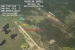
Huslia Airport (IATA: HSL, ICAO: PAHL, FAA LID: HLA) is a state-owned public-use airport located one nautical mile (1.85 km) east of Huslia.[11]
Facilities
Huslia Airport covers an area of 203 acres (82 ha) at an elevation of 220 feet (67 m) above mean sea level. It has one runway designated 3/21 with a gravel surface measuring 4,000 by 75 feet (1,219 x 23 m).[11] This replaced the former runway, which had the same designation and measured 3,000 by 60 feet (914 m × 18 m).[12]
Although most U.S. airports use the same three-letter location identifier for the FAA and IATA, this airport is assigned HLA by the FAA[11] and HSL by the IATA[13] (which assigned HLA to Lanseria Airport in Lanseria, South Africa[14]). The airport's ICAO identifier is PAHL.[15]
| Airlines | Destinations |
|---|---|
| Everts Air | Fairbanks[16] |
| Wright Air Service | Fairbanks, Galena, Hughes, Ruby, Tanana[17] |
References
- 1996 Alaska Municipal Officials Directory. Juneau: Alaska Municipal League/Alaska Department of Community and Regional Affairs. January 1996. p. 70.
- 2015 Alaska Municipal Officials Directory. Juneau: Alaska Municipal League. 2015. p. 76.
- "2019 U.S. Gazetteer Files". United States Census Bureau. Retrieved June 30, 2020.
- "Huslia city, Alaska". Profile of General Population and Housing Characteristics: 2010 Demographic Profile Data. United States Census Bureau. Archived from the original on February 12, 2020. Retrieved January 23, 2013.
- "Population and Housing Unit Estimates". United States Census Bureau. May 24, 2020. Retrieved May 27, 2020.
- "Huslia". Division of Community and Regional Affairs, Alaska Department of Commerce, Community and Economic Development. Retrieved January 24, 2013.
- "US Gazetteer files: 2010, 2000, and 1990". United States Census Bureau. 2011-02-12. Retrieved 2011-04-23.
- "Census of Population and Housing". Census.gov. Retrieved June 4, 2015.
- "U.S. Census website". United States Census Bureau. Retrieved 2008-01-31.
- "Jimmy Huntington School, Huslia." Yukon–Koyukuk School District. Retrieved on June 16, 2016.
- FAA Airport Form 5010 for HLA PDF, effective 2009-07-02.
- Annotated photo showing new runway under construction (JPG), FAA Alaska Region, June 2000.
- "HSL / PAHL - Huslia, Alaska". Great Circle Mapper. Retrieved 2009-08-07.
- "HLA / FALA - Lanseria Airport, South Africa". Aviation Safety Network. Retrieved 2009-08-07.
- "Alaskan ICAO Identifiers". Federal Aviation Administration. Archived from the original on 2009-07-28. Retrieved 2009-08-07.
- "Passenger Schedules". Retrieved 20 December 2020.
- "Timetable" (PDF). Wright Air Service. Retrieved December 20, 2020.
External links
- Alaska Division of Community and Regional Affairs: Huslia
- Constitution of the Native Tribe of Huslia, Alaska
Municipalities and communities of Yukon–Koyukuk Census Area, Alaska, United States | ||
|---|---|---|
| Cities | 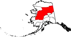 Yukon–Koyukuk Census Area map | |
| CDPs | ||
| Unincorporated communities | ||
| Ghost towns | ||
| ||
| Authority control |
|---|