I Street Bridge
The I Street Bridge is a historic metal truss swing bridge which crosses the Sacramento River to link the capital city of Sacramento, California, with Yolo County to the west. Built in 1911, this historic bridge has a vertical clearance of 14 feet 8 inches (4.47 m) and was originally part of State Route 16. It also carries two walkways; one on either side of the roadway.
I Street Bridge | |
|---|---|
.jpg.webp) | |
| Coordinates | 38°35′10″N 121°30′23″W |
| Carries | State Route 16 Union Pacific Railroad Martinez Subdivision |
| Crosses | Sacramento River |
| Locale | Sacramento, California |
| Official name | I Street Bridge |
| Named for | I Street (Sacramento) |
| Maintained by | Union Pacific Railroad |
| Characteristics | |
| Design | Swing bridge |
| Total length | 400 ft (120 m) |
| History | |
| Constructed by | American Bridge Company |
I Street Bridge | |
  | |
| Location | Sacramento, California |
| Coordinates | 38°35′11″N 121°30′25″W |
| Area | less than one acre |
| Built | 1911 |
| Architectural style | Double-Deck Steel Truss |
| NRHP reference No. | 82002233[1] |
| Added to NRHP | April 22, 1982 |
| Location | |

| |
The lower level of the bridge provides rail access to Sacramento from points south and west; the upper level provides highway access.
It was built to replace an 1867 timber Howe truss swing span bridge, which also carried both railroad and road traffic.[2]
Gallery
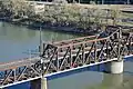 View from above, showing roadway on top deck and train tracks on lower deck
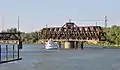 The swing span turned to allow a boat to pass
References
- "National Register Information System". National Register of Historic Places. National Park Service. July 9, 2010.
- John W. Snyder (February 2, 1981). "National Register of Historic Places Inventory/Nomination: I Street Bridge". National Park Service. Retrieved November 27, 2017. With three photos from 1961 and 1981.
External links
![]() Media related to I Street Bridge at Wikimedia Commons
Media related to I Street Bridge at Wikimedia Commons
- I Street Bridge (added 1982 - Structure - #82002233) CA 16, Sacramento
- I Street Bridge at Structurae. Retrieved 2011-11-11.
- NOAA NWS Advanced Hydrologic Prediction Service
- I Street Bridge Replacement
Crossings of the Sacramento River | ||||
|---|---|---|---|---|
| ||||
.svg.png.webp)
| .svg.png.webp) | |
† - Shared between Yolo and Sacramento Counties. | ||
| Topics | |
|---|---|
| Lists by state |
|
| Lists by insular areas | |
| Lists by associated state | |
| Other areas | |
| Related | |
| |
This article is issued from Wikipedia. The text is licensed under Creative Commons - Attribution - Sharealike. Additional terms may apply for the media files.
