Imer, Trentino
Imèr (German: Immer or Almern) is a comune (municipality) in Trentino, located about 50 kilometres (31 mi) east of Trento in northern Italy. As of 31 December 2004, it had a population of 1,213 and an area of 27.6 square kilometres (10.7 sq mi).[3]
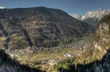
Imèr in Autumn
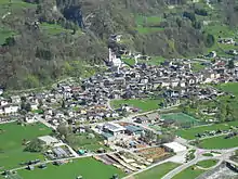
The central part of the village of Imèr
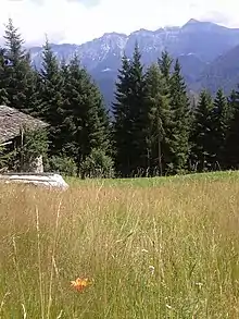
View of the Dolomites from near Imèr
Imèr | |
|---|---|
| Comune di Imer | |
Location of Imèr 
| |
 Imèr Location of Imèr in Italy  Imèr Imèr (Trentino-Alto Adige/Südtirol) | |
| Coordinates: 46°9′N 11°48′E | |
| Country | Italy |
| Region | Trentino-Alto Adige/Südtirol |
| Province | Trentino (TN) |
| Frazioni | Masi di Imèr, Pontet |
| Area | |
| • Total | 27.6 km2 (10.7 sq mi) |
| Elevation | 670 m (2,200 ft) |
| Population (Dec. 2004)[2] | |
| • Total | 1,213 |
| • Density | 44/km2 (110/sq mi) |
| Demonym(s) | Almeroi or armeroi |
| Time zone | UTC+1 (CET) |
| • Summer (DST) | UTC+2 (CEST) |
| Postal code | 38050 |
| Dialing code | 0439 |
| Website | Official website |
The municipality of Imer contains the frazioni (subdivisions, mainly villages and hamlets) Masi di Imèr, village Sass Maor and Pontet.
Imer borders the following municipalities: Primiero San Martino di Castrozza, Canal San Bovo, Mezzano and Sovramonte.
It includes the Vederne mountain and a part of the Noana valley.
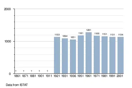
Demographic evolution
References
- "Superficie di Comuni Province e Regioni italiane al 9 ottobre 2011". Istat. Retrieved 16 March 2019.
- "Popolazione Residente al 1° Gennaio 2018". Istat. Retrieved 16 March 2019.
- All demographics and other statistics: Italian statistical institute Istat.
External links
- (in Italian) Homepage of the city

| Authority control |
|---|
This article is issued from Wikipedia. The text is licensed under Creative Commons - Attribution - Sharealike. Additional terms may apply for the media files.