Dambel
Dambel (German: Nombel; Nones: Dambel; Latin: Ambulum) is a comune (municipality) in Trentino in the northern Italian region Trentino-Alto Adige/Südtirol, located about 35 kilometres (22 mi) north of the city of Trento.
Dambel | |
|---|---|
| Comune di Dambel | |
Location of Dambel 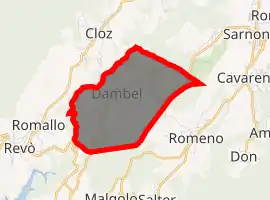
| |
 Dambel Location of Dambel in Italy 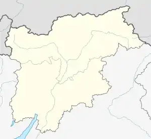 Dambel Dambel (Trentino-Alto Adige/Südtirol) | |
| Coordinates: 46°24′N 11°6′E | |
| Country | Italy |
| Region | Trentino-Alto Adige/Südtirol |
| Province | Trentino (TN) |
| Government | |
| • Mayor | Carlo Polastri |
| Area | |
| • Total | 5.1 km2 (2.0 sq mi) |
| Elevation | 750 m (2,460 ft) |
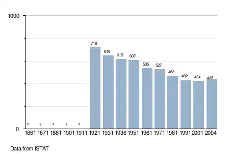
| Population (Dec. 2004)[2] | |
| • Total | 436 |
| • Density | 85/km2 (220/sq mi) |
| Demonym(s) | Dambellesi |
| Time zone | UTC+1 (CET) |
| • Summer (DST) | UTC+2 (CEST) |
| Postal code | 38010 |
| Dialing code | 0463 |
| Patron saint | Santa Maria Assunta |
| Saint day | August 15 |
| Website | Official website |
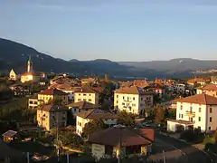
Dambel is located in the Val di Non at an elevation of 750 metres (2,460 ft). It is on the provincial highway between Sanzeno to the south and Sarnonico to the north. The town's name derives from the Latin word ambulum because it was at an historical crossroads on the commercial road between Lombardy and Germany, which crossed through Dambel and over the Novella River at the Pozzena bridge. Today the economy of Dambel is concentrated on the production of apples.
Geography
As of 31 December 2004, it had a population of 436 and an area of 5.1 square kilometres (2.0 sq mi).[3]
Dambel borders the following municipalities: Brez, Sarnonico, Cloz, Romallo, Romeno and Sanzeno.
Demographic evolution
References
- "Superficie di Comuni Province e Regioni italiane al 9 ottobre 2011". Istat. Retrieved 16 March 2019.
- "Popolazione Residente al 1° Gennaio 2018". Istat. Retrieved 16 March 2019.
- All demographics and other statistics: Italian statistical institute Istat.
External links
- (in Italian) Homepage of the city