Irai Island
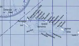
Irai Island is the main island of the Conflict Islands, which were sighted in 1879 by HMS Cormorant and named in 1880 by Bower, captain of HMS Conflict.[3]
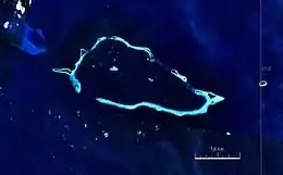 Satellite image | |
 | |
 Irai Island 10°46′03″S 151°41′33″E | |
| Geography | |
|---|---|
| Location | Oceania |
| Coordinates | 10°46′03″S 151°41′33″E[1] |
| Archipelago | Louisiade Archipelago |
| Adjacent bodies of water | Solomon Sea |
| Total islands | 1 |
| Major islands |
|
| Area | 1.08 km2 (0.42 sq mi) |
| Length | 6 km (3.7 mi) |
| Width | 0.25 km (0.155 mi) |
| Administration | |
| Province | |
| District | Samarai-Murua District |
| LLG [2] | Bwanabwana Rural LLG |
| Island Group | Calvados Chain |
| Largest settlement | Copra Plantation (pop. 20) |
| Demographics | |
| Population | 20 (2014) |
| Pop. density | 18.5/km2 (47.9/sq mi) |
| Ethnic groups | Papauans, Austronesians, Melanesians. |
| Additional information | |
| Time zone |
|
| ISO code | PG-MBA |
| Official website | www |
References
- Prostar Sailing Directions 2004 New Guinea Enroute, p. 168
- LLG map
- Arthur Wichman (Hrsg.): History of New-Guinea (bis 1828). Bd. 1, E. J. Brill, Leiden 1909, S. 271
This article is issued from Wikipedia. The text is licensed under Creative Commons - Attribution - Sharealike. Additional terms may apply for the media files.
