Islandmagee
Islandmagee (from Irish: Oileán Mhic Aodha, meaning "Magee’s island/peninsula")[1] is a peninsula and civil parish on the east coast of County Antrim, Northern Ireland, located between the towns of Larne and Whitehead. It is part of the Mid and East Antrim Borough Council area and is a sparsely populated rural community with a long history since the mesolithic period. In the early medieval period it was known as Semne, a petty-kingdom within Ulaid.
Islandmagee
| |
|---|---|
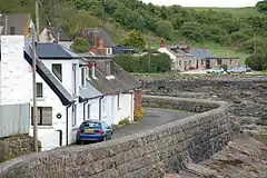 Cottages near Browns Bay, Islandmagee, in 2006 | |
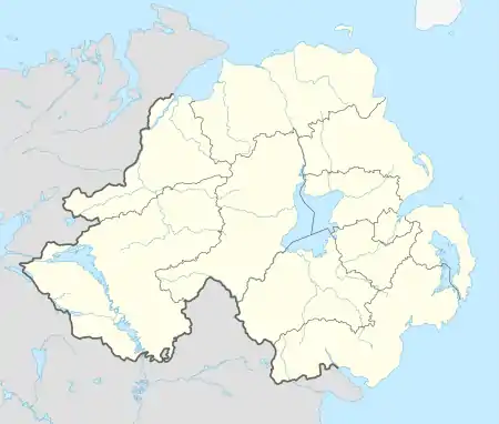 Islandmagee Location within Northern Ireland | |
| • Belfast | 18 mi (29 km) |
| District | |
| County | |
| Country | Northern Ireland |
| Sovereign state | United Kingdom |
| Post town | LARNE |
| Postcode district | BT40 |
| Dialling code | 028 |
| UK Parliament | |
| NI Assembly | |
It is the site of Northern Ireland's main power station Ballylumford and the endpoint of the Scotland-Northern Ireland gas pipeline.
History
The name comes from Mac Aodha (Magee) a prominent Irish family in the area. An earlier Irish name was Rinn Seimhne (peninsula of (the district of) Seimhne) from an original tribal name.[1]
The Bissett family held the tenancy of the peninsula in Elizabeth I's reign, their rent being an annual offering of goshawks, birds which bred on the rugged white chalk cliffs nearby. It was the site of a witch trial in 1710 where eight women were convicted of witchcraft and sentenced to a year's imprisonment.
Islandmagee was the site of the massacre of more than 3,000 Irish Catholics at the outset of the Irish Rebellion of 1641, with one witness testifying, 'About the beginning of November, the English and Scots forces in [Carrickfergus] murdered in one night, all the inhabitants of the territory of Islandmagee to the number of above 3,000 men women and children, all innocent persons, in a time when none of the Catholics of that county were in arms or [in] rebellion. Note that this was the first massacre committed in Ireland of either side’.[2]
Archaeology
- Islandmagee is the home of the Ballylumford Dolmen. Known locally as the "Druid's Altar", this megalithic monument could date to 2500 BC (The Early Bronze Age), or be the remains of an earlier Neolithic simple passage tomb dating to c. 4000 BC. It consists of four upright stones, with a heavy capstone and a fallenstone within the structure. The fallenstone may have been put there to block the entrance to the tomb.[3]
- Neolithic houses have been excavated at Ballyharry, on the Islandmagee peninsula.[4] Finds included Neolithic pottery, flint arrowheads, javelin heads, polished stone axe fragments and quernstones.[5]
Sport
- Islandmagee F.C. plays in the Northern Amateur Football League.
- Larne Golf Club (9 holes) lies on the peninsula, in addition to two horseriding centres - Rocklyn stables and Islandmagee Riding Centre.
- Fishing continues to be the most common sport practiced in the region.
Civil parish of Island Magee
The peninsula is part of the parish of Island Magee. The boundaries of the parish and the peninsula match.
Townlands
The civil parish contains the following townlands:[6]
- Balloo
- Ballycronan Beg
- Ballycronan More
- Ballydown
- Ballyharry
- Ballykeel
- Ballylumford
- Ballymoney
- Ballymuldrogh
- Ballyprior Beg
- Ballyprior More
- Ballystrudder
- Ballytober
- Carnspindle
- Castletown
- Cloghfin
- Drumgurland
- Dundressan
- Gransha
- Kilcoan Beg
- Kilcoan More
- Mullaghboy
- Mullaghdoo
- Portmuck
- Temple-effin
References
- "Island Magee". Place Names NI. Retrieved 4 May 2015.
- John Gibney, ‘What about Islandmagee?’ Another version of the 1641 rebellion (History Ireland, 2013)
- "Ballylumford Dolmen". Discover Northern Ireland. Retrieved 5 December 2007.
- O'Sullivan, Aidan; Breen, Colin (2007). Maritime Ireland. An Archaeology of Coastal Communities. Stroud: Tempus. p. 65. ISBN 978-0-7524-2509-2.
- "Investigations at Ballyharry Farm, Ballyharry, County Antrim" (PDF). Centre for Archaeological Fieldwork. Archived from the original (PDF) on 13 June 2011. Retrieved 5 December 2009.
- "Islandmagee". IreAtlas Townlands Database. Retrieved 4 May 2015.
- "Your Area: Islandmagee". Culture Northern Ireland. Archived from the original on 9 June 2008. Retrieved 28 December 2009.
| Wikimedia Commons has media related to Islandmagee. |
External links
- Islandmagee Community website
- Islandmagee Community Facebook Page
- Page with Islandmagee Townland Map