JOSM
JOSM (![]() listen ) (Java OpenStreetMap Editor) is a free software desktop editing tool for OpenStreetMap geodata created in Java, originally developed by Immanuel Scholz and currently maintained by Dirk Stöcker.[4] The editing tool contains advanced features[5] that are not present in OSM's default online editor, iD.
listen ) (Java OpenStreetMap Editor) is a free software desktop editing tool for OpenStreetMap geodata created in Java, originally developed by Immanuel Scholz and currently maintained by Dirk Stöcker.[4] The editing tool contains advanced features[5] that are not present in OSM's default online editor, iD.
 | |
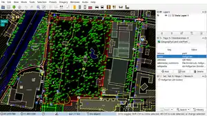 JOSM with single OpenStreetMap data layer displayed | |
| Original author(s) | Immanuel Scholz |
|---|---|
| Developer(s) | Dirk Stöcker and other contributors |
| Initial release | January 22, 2006[1] |
| Stable release | 17428
/ December 29, 2020[2] |
| Repository | |
| Written in | Java[2] |
| Platform | Cross-platform |
| Available in | 38[3] languages |
| Type | GIS software |
| License | GNU GPL v2 |
| Website | josm |
Features
Some notable features of JOSM are importing GPX files (GPS tracks),[6] working with aerial imagery (including WMS, TMS and WMTS protocols), support for multiple cartographic projections, layers, relations editing,[7] data validation tools, data filtering, offline work,[8] presets and rendering styles.[9] JOSM provides more than 200 keyboard shortcuts for the core functions.[10]
Many additional features (like tools for drawing buildings, adding Wikipedia links or viewing data in 3D) are available through the plugins.[11][12][13][14] There are more than 100 of them in the repository.[15]
History
The first changeset was created on 27 September 2005.[16] The first beta version (which required Java 5)[17] was made available on 4 October 2005 and JOSM 1.0 was released on 22 January 2006.[1] The current versioning scheme, using code changeset number, was introduced in 2008.[18]
In 2014 the project logo was replaced with the current artwork, which won a design contest.[19] From this year stable releases are identified with additional YY.MM internal version number (following r6763 - 14.01[20]), however they may not exactly reflect the release date.[21]
Since revision 10786 (16.07) released on 12 August 2016, support for Java versions earlier than 8 has been dropped.[2]
Usage
The highest number of edits in OSM is done using JOSM.[22] The software was used to perform several large scale OSM imports, including TIGER data in the United States.[23]
JOSM can also be used for editing an OSM sister project OpenHistoricalMap.[24] It's included as a package in many Linux distributions like Ubuntu,[25][26] Debian,[27] Fedora,[28] Arch Linux[29] and the OSGEO Live DVD[30]
Various tutorials are available. The LearnOSM Tutorial, translated in 16 languages, has a section on JOSM.[31] It covers the editing process, the tools, the plugins, the presets, the imagery functionalities, conflict resolution and other features.
References
- "Archived copy". Archived from the original on 2016-09-18. Retrieved 2016-05-21.CS1 maint: archived copy as title (link)
- "Changelog – JOSM". Josm.openstreetmap.de.
- "svn - Revision 16030: /trunk/resources/data". josm.openstreetmap.org.
- "JOSM". OpenStreetMap Wiki.
- Jokar Arsanjani, J.; Zipf, A.; Mooney, P.; Helbich, M., eds. (2015). OpenStreetMap in GIScience: Experiences, Research, and Applications. Lecture Notes in Geoinformation and Cartography. Springer. p. 71. ISBN 978-3-319-14280-7.
- Geographic Information Systems: Concepts, Methodologies, Tools, and Applications. USA: Information Resources Management Association. 2013. p. 546. ISBN 978-1466620384.
- Maben, Ruth (29 June 2017). "Mapping complex features in JOSM using relations". Mapbox.ocm.
- "Comparison of editors - OpenStreetMap Wiki". Wiki.openstreetmap.org.
- Bennett Jonathan (September 2010). OpenStreetMap. PacktPub. ISBN 9781847197504. Retrieved 22 May 2016.
- "DevelopersGuide/ShortcutsList – JOSM". Josm.openstreetmap.org.
- "LearnOSM". Learnosm.org.
- Chance Tom (March 6, 2009). "OpenStreetMap: the data behind the maps". Linux Weekly News. Retrieved 22 May 2016.
- Michael Zilske; Andreas Neumann; Kai Nagel (2 September 2015). "OpenStreetMap for traffic simulation". Proceedings of the 1st European state of the map : OpenStreetMap conference. Technische Universitat Berlin Collection. doi:10.14279/depositonce-4679. Retrieved 22 May 2016.
- F Scioscia; M Binetti; M Ruta; S Ieva; Eugenio Di Sciascio (5 February 2014). "A Framework and a Tool for Semantic Annotation of POIs in OpenStreetMap". Procedia - Social and Behavioral Sciences. 111: 1092–1101. doi:10.1016/j.sbspro.2014.01.144.
- "- Revision 32802". Svn.openstreetmap.org.
- "Changeset 1 – JOSM". Josm.openstreetmap.de.
- "Archived copy". Archived from the original on 2016-12-11. Retrieved 2016-05-22.CS1 maint: archived copy as title (link)
- "OpenStreetMap - josmeditor's diary - JOSM reaches version 10000 in its 10th year". Openstreetmap.org.
- "A new logo for JOSM, the Java OpenStreetMap Editor - OpenStreetMap Blog". Blog.openstrretmap.org.
- "2014 Changelog". Retrieved 7 November 2016.
- Legner, Simon (6 November 2016). "16.10 release". The josm-dev Archives. Retrieved 7 November 2016.
- "Editor usage stats - OpenStreetMap Wiki". Wiki.openstreetmap.org.
- Nathan Willis (23 January 2008). "OpenStreetMap project completes import of United States TIGER data". Linux.com. Retrieved 22 May 2016.
- "Open Historical Map - OpenStreetMap Wiki". Wiki.openstreetmap.org.
- "JOSM". Help.ubuntu.com. 10 December 2009. Retrieved 22 May 2016.
- "JOSM". Ubuntuusers.de. 22 April 2016. Retrieved 22 May 2016.
- "Debian -- Details of package josm in jessie". Packages.debian.org. Retrieved 2017-04-06.
- "rpms/josm | PkgDB". Admin.fedoraproject.org. Retrieved 2017-04-06.
- "Arch Linux - josm 11826-1 (any)". Archlinux.org. Retrieved 2017-04-06.
- "OSGEO-DVD". OSGEO. Retrieved 22 May 2016.
- "LearnOSM". Learnosm.org.
External links
| Wikimedia Commons has media related to JOSM. |
OpenStreetMap (OSM) | ||
|---|---|---|
| Related persons, organizations and events | ||
| OSM-based movements | ||
| Service providers (commercial) | ||
| OSM editors | ||
| OSM map renders | ||
| Software using OSM database |
| |
| Similar free projects | ||
| Proprietary equivalents | ||