Kōtō
Kōtō (江東区, Kōtō-ku) is a special ward located in Tokyo Metropolis, Japan. The ward refers to itself as Kōtō City in English. As of May 1, 2015, the ward has an estimated population of 488,632, and a population density of 12,170 persons per km². The total area is approximately 40.16 km².
Kōtō
江東区 | |
|---|---|
| Kōtō City | |
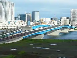 Great Harumi Bridge in Kōtō | |
 Flag  Emblem | |
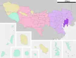 Location of Kōtō in Tokyo | |
 Kōtō Location in Japan | |
| Coordinates: 35°40′N 139°49′E | |
| Country | Japan |
| Region | Kantō |
| Prefecture | Tokyo |
| Government | |
| • Mayor | Takaaki Yamazaki[1] |
| Area | |
| • Total | 40.16 km2 (15.51 sq mi) |
| Population (May 1, 2015) | |
| • Total | 488,632 |
| • Density | 12,170/km2 (31,500/sq mi) |
| Time zone | UTC+09:00 (JST) |
| City hall address | 東陽4-11-28 135-8383 |
| Website | www |
Kōtō is located east of the Tokyo metropolitan center, bounded by the Sumida River to the west and the Arakawa River to the east. Its major districts include Kameido, Kiba, Kiyosumi, Monzen-nakachō, Shirakawa, and Toyosu. The waterfront area of Ariake is in Kōtō, as is part of Odaiba.
Etymology
"Kōtō" (江東) means "East [of the] River" in Japanese. The tō (東) in Kōtō means "East" and is the same character as the Tō in Tokyo (東京).
Geography
Kōtō occupies a position on the waterfront of Tokyo Bay sandwiched between the wards of Chūō and Edogawa. Its inland boundary is with Sumida. Much of the land is reclaimed, The northern part is old reclaimed land, and the elevation is very low(below sea level. The southern part is relatively new, but there are few old temples or shrines.
Noteworthy places in Kōtō include:
- In the former ward of Fukagawa: Kiba, Fukagawa, Edagawa;
- In the former ward of Jōtō: Kameido, Ōjima, Sunamachi;
- On recently reclaimed land: Ariake, Yumenoshima, Tokyo Rinkai Fukutoshin.
History
The western part of the ward was formerly part of Fukagawa Ward of Tokyo City. It suffered severe damage in the 1923 Great Kantō earthquake, and was heavily bombed during World War II. The special ward was founded on March 15, 1947, by the merger of the wards of Fukagawa and Jōtō.
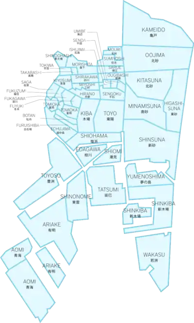
Districts
There are 45 districts in Koto:[2]
|
|
|
|
|
Transportation
Rail
- JR East
- Chūō-Sōbu Line: Kameido Station
- Keiyō Line: Etchūjima Station, Shiomi Station, Shin-kiba Station
- JR Freight
- Etchūjima Branch Line: Etchūjima Freight Terminal
- Tokyo Metro
- Tokyo Metropolitan Bureau of Transportation
- Tobu Railway
- Tokyo Waterfront Area Rapid Transit
- Yurikamome
Highway
- Shuto Expressway
- C2 Central Loop (Itabashi JCT – Kasai JCT)
- No.7 Komatsugawa Route (Ryogoku JCT – Yagochi)
- No.9 Fukagawa Route (Hakozaki JCT – Tatsumi JCT)
- B Bayshore Route (Kawasaki-ukishima JCT – Koya)
Air
Economy
Companies with headquarters in Koto include Daimaru Matsuzakaya Department Stores,[3] Ibex Airlines,[4] Fujikura,[5] and Maruha Nichiro.[6]
Sony operates the Ariake Business Center in Kōtō.[7] The broadcasting center of WOWOW is in Koto.[8][9]
Seta Corporation was headquartered in Kōtō.[10]
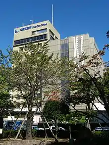
Government
The main city office for Kōtō City is located in Toyo. There are branch offices located in Shirakawa, Tomioka, Toyosu, Komatsubashi, Kameido, Ojima, Sunamachi and Minamisuna.[11]
Notable places
- AgeHa nightclub
- Kameido Tenjin Shrine
- Tomioka Hachiman Shrine
- Fukagawa Edo Museum
- Fukagawa Fudo-son
- Kiyosumi Garden
- Museum of Contemporary Art Tokyo in Kiba Park
- Tokyo Big Sight (Tokyo International Exhibition Center)
- Ariake Coliseum, site of Japan Open Tennis Championships, All Japan Tennis Championships
- Ariake Tennis Forest Park, which has Ariake Coliseum and 48 tennis courts
- Suzaki Baseball Field, site of Japanese Baseball League games in 1930s
- Kiba Metropolitan Park
- Yumenoshima Tropical Greenhouse Dome
- Shin-Kiba 1st Ring
- Tokyo Gate Bridge
- Dream Bridge
Education
Colleges and universities
- Ariake Junior College of Education and the Arts (Ariake Kyōiku Geijutsu Tanki Dbigaku)
- Tokyo University of Marine Science and Technology (Tokyo Kaiyo Daigaku, part of the national university system)
- Shibaura Institute of Technology (Shibaura Kougyō Daigaku)
Primary and secondary schools
Public elementary and middle schools are operated by the Koto City Board of Education. Public high schools are operated by the Tokyo Metropolitan Government Board of Education.
- Daisan Commercial High School
- Fukagawa High School
- Higashi High School
- High School of Science and Technology
- Johtoh High School
- Koto Business High School
- Oedo High School
- Sumida Technical High School
International schools
International schools are independently owned and operated.
- K. International School Tokyo
- India International School in Japan
- Tokyo Second Korean Elementary School (東京朝鮮第二初級学校) – North Korean school[12]
International relations
As of April 20, 1989, Kōtō became the Sister City of Surrey, British Columbia, Canada.[13]
Notable people from Kōtō
- Shōta Sometani, Japanese actor
- Takaaki Yamazaki, Japanese politician and the current mayor of Kōtō
- Kazuto Sakata, Japanese former professional motorcycle racer and two-time F.I.M. 125cc world champion
- Anne Nakamura (Real Name: Yuko Nakamura, Nihongo: 中村 友子, Nakamura Yūko), Japanese model, tarento and actress
- Daisuke Gōri, Japanese actor, voice actor and narrator
- Genki Sudo, Japanese politician, former entertainer and kickboxer
- Ben Kimura, Japanese politician
- Tomokazu Seki, Japanese actor, voice actor and singer
- Hiroshi Yamamoto, Japanese professional shogi player ranked 4-dan
- Tomomi Kahara (Real Name: Tomomi Shimogawara, Nihongo: 下河原 朋美, Shimogawara Tomomi), Japanese pop singer
- Akihito Hirose, Japanese professional shogi player ranked 8-dan
- Hiromu Watanabe, Japanese professional shogi player ranked 5-dan
- Yasuko Kobayashi, Japanese anime and tokusatsu drama screenwriter
- Yōhei Kajiyama, Japanese former football player
- Yugo Iiyama, Japanese football player (Iwate Grulla Morioka, J3 League)
- Tetsuo Kurata (Real Name: Tetsuo Kakimoto, Nihongo: 柿本 哲夫, Kakimoto Tetsuo) Japanese television, stage, film actor and restaurateur (Kamen Rider Black and Kamen Rider Black RX)
References
- 平成27年市長選挙結果. Retrieved August 30, 2015.
- "Archived copy" 江東区の地理と地名. Archived from the original on April 18, 2015. Retrieved April 28, 2015.CS1 maint: archived copy as title (link)
- "会社概要・役員." Daimaru Matsuzakaya Department Stores. Retrieved on December 15, 2010. "本店所在地 東京都江東区木場二丁目18番11号."
- "Corporate Profile Archived 2009-05-27 at the Wayback Machine." Ibex Airlines. Retrieved on May 20, 2009.
- " Corporate Profile Archived 2014-05-02 at the Wayback Machine." Fujikura. Retrieved on June 17, 2014.
- "Corporate Data Archived 2017-08-07 at the Wayback Machine." Maruha Nichiro. Retrieved on April 4, 2014.
- "Access & Map." Sony. Retrieved on January 19, 2009.
- "Corporate Info." WOWOW. Retrieved on November 20, 2010. "2-1-58, Tatsumi, Koto-ku, Tokyo 135-0053" Addresses in Japanese: "東京都江東区辰巳2-1-58"
- "Broadcasting Center." (Direct image link) WOWOW. Retrieved on November 20, 2010. Map in Japanese (Direct link)
- "Corporation Data." Seta Corporation. February 6, 2007. Retrieved on April 24, 2009.
- Koto City webpage Koto City/English/Koto City Office Guide Archived November 11, 2014, at the Wayback Machine Retrieved November 21, 2014
- "Archived copy" ウリハッキョ一覧. Archived from the original on December 19, 2015. Retrieved October 14, 2015.
東京朝鮮第二初級学校 135-0051 東京都江東区枝川1-11-26
CS1 maint: archived copy as title (link)" (). - "Sister & Friendship Cities". City of Surrey. Archived from the original on August 6, 2013.
External links
| Wikimedia Commons has media related to Koto, Tokyo. |
- Kōtō City Official Website (in Japanese)
| Districts |
| | ||||
|---|---|---|---|---|---|---|
| Education | ||||||
| Major stations |
| |||||
| Landmarks | ||||||
| |||||||
| Special Wards of Tokyo | |||||||
| Western (Tama area) |
| ||||||
| Subprefectures | |||||||
| |||||||
| Authority control |
|---|