Takasaki
Takasaki (高崎市, Takasaki-shi, [takasakiɕi]) is a city located in Gunma Prefecture, Japan. As of 31 August 2020, the city had an estimated population of 372,369 in 167,345 households,[1] and a population density of 810 persons per km². The total area of the city is 459.16 square kilometres (177.28 sq mi). Takasaki is famous as the hometown of the Daruma doll, theoretically representing the Buddhist sage Bodhidharma and in modern practice a symbol of good luck. Making the largest city on prefecture (1990) after beating the Maebashi.
Takasaki
高崎市 | |
|---|---|
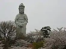
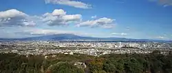 City view from Takasaki Kannon | |
 Flag  Seal | |
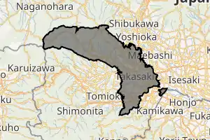
Location of Takasaki in Gunma Prefecture | |
 | |
 Takasaki | |
| Coordinates: 36°19′18.8″N 139°0′11.8″E | |
| Country | Japan |
| Region | Kantō |
| Prefecture | Gunma |
| Government | |
| • Mayor | Kenji Tomioka (since May 2011) |
| Area | |
| • Total | 459.16 km2 (177.28 sq mi) |
| Population (August 31, 2020) | |
| • Total | 372,369 |
| • Density | 810/km2 (2,100/sq mi) |
| Time zone | UTC+9 (Japan Standard Time) |
| Symbols | |
| • Tree | Zelkova serrata, Cyclobalanopsis |
| • Flower | Sakura |
| • Bird | Japanese bush-warbler |
| Phone number | 027-321-111 |
| Address | Takamatsu-cho 35-1, Takasaki-shi, Gunma-ken 370-8501 |
| Website | Official website |
Geography
Takasaki is located in the southwestern part of Gunma Prefecture in the flat northwestern part of the Kantō Plain. The city is located approximately 100 kilometers from the center of Tokyo. Mount Akagi, Mount Haruna and Mount Myogi can be seen from the city, and the southern slopes of Mount Haruna are within the city limits. The Tone River, Karasu River and Usui River flow through the city. Although Takasaki is located over 100 kilometers from the coast, much of the city is low-lying, and the elevation of the city hall and central city area is only 97 meters above sea level. The land rises to the northern and western parts of the city to a maximum elevation of 1690 meters.
Surrounding municipalities
Climate
Takasaki has a Humid continental climate (Köppen Cfa) characterized by warm summers and cold winters with heavy snowfall. The average annual temperature in Takasaki is 14.2 °C. The average annual rainfall is 1247 mm with September as the wettest month. The temperatures are highest on average in August, at around 26.3 °C, and lowest in January, at around 3.1 °C.[2]
| Climate data for Kamisatomi (1981-2010) | |||||||||||||
|---|---|---|---|---|---|---|---|---|---|---|---|---|---|
| Month | Jan | Feb | Mar | Apr | May | Jun | Jul | Aug | Sep | Oct | Nov | Dec | Year |
| Record high °C (°F) | 20.1 (68.2) |
24.1 (75.4) |
27.9 (82.2) |
32.0 (89.6) |
35.6 (96.1) |
39.0 (102.2) |
40.3 (104.5) |
38.1 (100.6) |
38.8 (101.8) |
32.1 (89.8) |
25.4 (77.7) |
24.0 (75.2) |
40.3 (104.5) |
| Average high °C (°F) | 8.9 (48.0) |
9.6 (49.3) |
13.0 (55.4) |
18.8 (65.8) |
23.3 (73.9) |
25.9 (78.6) |
29.3 (84.7) |
30.8 (87.4) |
26.4 (79.5) |
21.2 (70.2) |
16.1 (61.0) |
11.5 (52.7) |
19.6 (67.3) |
| Daily mean °C (°F) | 2.4 (36.3) |
3.1 (37.6) |
6.5 (43.7) |
12.3 (54.1) |
17.1 (62.8) |
20.7 (69.3) |
24.2 (75.6) |
25.5 (77.9) |
21.4 (70.5) |
15.5 (59.9) |
9.7 (49.5) |
4.8 (40.6) |
13.6 (56.5) |
| Average low °C (°F) | −2.8 (27.0) |
−2.4 (27.7) |
0.6 (33.1) |
6.2 (43.2) |
11.4 (52.5) |
16.2 (61.2) |
20.2 (68.4) |
21.4 (70.5) |
17.5 (63.5) |
10.9 (51.6) |
4.7 (40.5) |
−0.4 (31.3) |
8.6 (47.5) |
| Record low °C (°F) | −9.0 (15.8) |
−9.3 (15.3) |
−7.1 (19.2) |
−3.4 (25.9) |
0.9 (33.6) |
6.8 (44.2) |
11.9 (53.4) |
13.5 (56.3) |
7.0 (44.6) |
1.0 (33.8) |
−2.9 (26.8) |
−7.6 (18.3) |
−9.3 (15.3) |
| Average precipitation mm (inches) | 25.3 (1.00) |
31.6 (1.24) |
62.3 (2.45) |
80.1 (3.15) |
113.0 (4.45) |
167.7 (6.60) |
227.2 (8.94) |
240.1 (9.45) |
234.9 (9.25) |
121.1 (4.77) |
48.8 (1.92) |
22.0 (0.87) |
1,374 (54.09) |
| Mean monthly sunshine hours | 195.6 | 188.0 | 199.0 | 198.2 | 188.4 | 136.1 | 147.2 | 170.0 | 129.6 | 155.1 | 171.8 | 192.1 | 2,070.8 |
| Source 1: 理科年表 | |||||||||||||
| Source 2: Japan Meteorological Agency (Averages:1981-2010、Peaks:1888-present)[3][4] | |||||||||||||
Demographics
Per Japanese census data,[5] the population of Takasaki has increased relatively steadily over the past 50 years.
| Year | Pop. | ±% |
|---|---|---|
| 1960 | 244,376 | — |
| 1970 | 280,625 | +14.8% |
| 1980 | 323,403 | +15.2% |
| 1990 | 346,933 | +7.3% |
| 2000 | 358,465 | +3.3% |
| 2010 | 371,352 | +3.6% |
History
During the Edo period, the area of present-day Takasaki was the center of the Takasaki Domain, a feudal domain held by a branch of the Matsudaira clan under the Tokugawa shogunate in Kōzuke Province. The area also prospered from its location on the Nakasendō highway connecting Edo with Kyoto. Post stations located within the borders of modern Takasaki were: Shinmachi-shuku, Kuragano-shuku, and Takasaki-shuku. Following the Meiji Restoration, Takasaki was briefly capital of Gunma Prefecture, before the capital was moved to Maebashi in 1881.
Takasaki Town was created within Gunma District, Gunma on April 1, 1889 with the creation of the modern municipalities system. It was raised to city status on April 1, 1900. On April 1, 1927, Takasaki annexed the neighboring villages of Tsukasawa and Kataoka, followed by Sano on October 1, 1937. The city largely escaped damage in World War II. Following the war, it continued to expand its borders by annexing the village of Rokugo on April 1, 1951, Shintakao and Nakamura as well as Yawata and Toyooka from Ushi District on January 20, 1955. This was followed by Orui village and Sano village from Tano District on September 30, 1956. The city celebrated its 360th anniversary in 1963 and annexed the town of Kuragano on March 31 of the same year. On September 1, 1965 the village of Gunnan was annexed.
In September 1987, five-year-old Yoshiaki Ogiwara, the son of a local firefighter, was abducted and subsequently murdered in Takasaki. The murder received heavy media coverage across Japan.[6]
On April 1, 2001 Takasaki was proclaimed a Special City (Tokurei-shi), which gave it greater autonomy.
On January 23, 2006, the towns of Gunma, Kurabuchi and Misato (all from Gunma District), and the town of Shinmachi (from Tano District) were merged into Takasaki. On October 1, 2006, the town of Haruna (from Gunma District) was merged into expanded city of Takasaki. Gunma District was dissolved as a result of this merger. On June 1, 2009, the town of Yoshii (from Tano District) was merged into expanded city of Takasaki.[7]
Takasaki was elevated to a Core city with even greater autonomy on April 1, 2011.
Government
Takasaki has a mayor-council form of government with a directly elected mayor and a unicameral city council of 38 members. Takasaki contributes nine members to the Gunma Prefectural Assembly. In terms of national politics, the city is divided between the Gunma 4th district and Gunma 5th district of the lower house of the Diet of Japan.
Economy
Takasaki is a regional commercial center and transportation hub, and is a major industrial center within Gunma Prefecture. Companies headquartered in Takasaki include:
- CUSCO Japan – automotive parts
- Yamada Denki – home appliance retailer
Education
Universities and colleges
- Takasaki City University of Economics
- Takasaki University of Commerce
- Takasaki University of Health and Welfare
- Gumma Paz College
- Jobu University
- Ikuei Junior College
- Takasaki University of Health and Welfare Junior College
- Takasaki University of Commerce Junior College
- Niijima Gakuen Junior College
Primary and secondary education
- Takasaki has sixty public elementary schools and 25 public middle schools operated by the city government and eight public high schools operated by the Gunma Prefecture Board of Education. In addition, the city operates one public high school and there are five private high schools. The prefecture also operates five special education schools for the handicapped.
Transportation
Railway
![]() JR East – Hokuriku Shinkansen
JR East – Hokuriku Shinkansen
![]() JR East – Jōetsu Shinkansen
JR East – Jōetsu Shinkansen
![]() JR East – Takasaki Line, Shōnan-Shinjuku Line, Ueno-Tokyo Line
JR East – Takasaki Line, Shōnan-Shinjuku Line, Ueno-Tokyo Line
![]() Jōshin Dentetsu
Jōshin Dentetsu
Highway
.png.webp) Kan-etsu Expressway – Takasaki-Tamamura Smart Interchange – Takasaki Junction – Takasaki Interchange – Maebashi Interchange
Kan-etsu Expressway – Takasaki-Tamamura Smart Interchange – Takasaki Junction – Takasaki Interchange – Maebashi Interchange.png.webp) Jōshin-etsu Expressway – Yoshii Interchange
Jōshin-etsu Expressway – Yoshii Interchange.png.webp) Kita-Kantō Expressway – Takasaki Junction
Kita-Kantō Expressway – Takasaki Junction National Route 17
 National Route 18
 National Route 254
 National Route 354
 National Route 406
Local attractions
- Takasaki Castle
- Mount Haruna
- Lake Haruna
- Haruna Shrine
- Minowa Castle
- The Museum of Modern Art, Gunma
- The sound of a suikinkutsu in the Suikintei Garden of former Yoshii town is designated as one of the 100 Soundscapes of Japan by the Ministry of the Environment [8]
Sport
- Arte Takasaki - football (soccer) club
Twin towns – sister cities
 Battle Creek, United States (1981)
 Muntinlupa, Philippines (2006)
 Plzeň, Czech Republic (1990)
 Santo André, Brazil (1981)
Notable people
- Toll Yagami, musician (Buck-Tick)
- Yutaka Higuchi, musician (Buck-Tick)
- Takeo Fukuda, former Prime Minister of Japan
- Yasuo Fukuda, former Prime Minister of Japan
- Kyosuke Himuro, musician (Boøwy)
- Tomoyasu Hotei, musician (Boøwy)
- Fujio Masuoka, inventor of flash memory
- Kanai Mieko (born in Takasaki 1947), writer
- Hirofumi Nakasone, politician
- Yasuhiro Nakasone, former Prime Minister of Japan
- Kiyoshi Ogawa, Imperial Japanese Navy kamikaze pilot
- Hakubun Shimomura, politician
- German architect Bruno Taut lived for some time in Takasaki
- Kenji Tsukagoshi, navigator and aviator
References
- "Takasaki City official statistics" (in Japanese). Japan.
- Takasaki climate data
- "平年値(年・月ごとの値)". Japan Meteorological Agency. Retrieved August 10, 2012.
- "観測史上1~10位の値(年間を通じての値)". Japan Meteorological Agency. Retrieved August 10, 2012.
- Takasaki population statistics
- Kristof, Nicholas D. "Kidnap-murder of 5-year-old shakes Japan," The New York Times, 20 September 1987. Retrieved 12 April 2015.
- Information at kokudo.or.jp Archived August 21, 2006, at the Wayback Machine
- "100 Soundscapes of Japan". Ministry of the Environment. Retrieved 8 December 2015.
- "友好都市". city.takasaki.gunma.jp (in Japanese). Takasaki. Retrieved 2020-04-08.
External links
| Wikimedia Commons has media related to Takasaki, Gunma. |
- Official Website (in Japanese)
| Core cities | ||
|---|---|---|
| Special cities | ||
| Cities | ||
| Districts | ||
| Authority control |
|---|
