K-25 (Kansas highway)
K-25 is a 238.259-mile-long (383.441 km) south–north state highway in the U.S. State of Kansas. K-25 runs from Oklahoma State Highway 136 (SH-136) at the Oklahoma State Line to Nebraska Highway 25 (N-25) at the Nebraska border, running through Leoti, Colby, and Atwood plus many more towns along the way.
| ||||
|---|---|---|---|---|
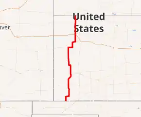
K-25 highlighted in red | ||||
| Route information | ||||
| Maintained by KDOT and the cities of Ulysses, Lakin and Colby | ||||
| Length | 238.259 mi[1] (383.441 km) | |||
| Existed | 1927[2]–present | |||
| Major junctions | ||||
| South end | ||||
| North end | ||||
| Location | ||||
| Counties | Stevens, Grant, Kearny, Wichita, Logan, Thomas, Rawlins | |||
| Highway system | ||||
| ||||

K-25 was first designated as a state highway in 1927 and at that time began at K-45 west of Moscow, and ran north to the Nebraska border and continued as N-25. In 1959, the highway was extended south from, US-56 and K-51 to the Oklahoma border.
Route description
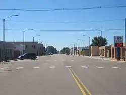
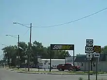
K-25 enters Kansas from Oklahoma, acting as a continuation of SH-136. K-25 continues relatively due north through flat land until it meets U.S. Route 56 (US-56) and K-51. K-25 turns northeast on the two routes, which K-25 is concurrent with until Hugoton, when K-25 and K-51 split off of US-51. North of town, K-25 splits off of K-51, and K-25 continues in the same fashion as it did, passing through Ulysses, where US-160 is intersected, Lakin, where K-25 junctions US-50 and US-400 at the same time, and Leoti, where K-96 is intersected.
After leaving Leoti, K-25 continues due north for about 20 miles, until the route turns east for about 8 miles, until turning back north, immediately passing through Russell Springs. North of Russell Springs, US-40 is intersected, sharing an overlap for about ten miles. After turning onto US-40, the road starts to become hillier. K-25 separates just west of Baker. From there, it goes north to Colby, traveling through lightly rolling hills. Just south of Colby, I-70 is junctioned, with a good number of services near the interchange. K-25 then becomes a 4 lane divided highway until it enters Colby, where it changes back into a surface street. Within the Colby city limits, US-24 is intersected. K-25 continues out of Colby, alternating between flat and rolling land. In Atwood, US-36 is intersected. K-25 leaves Atwood traveling through rolling hills at first, but flattens out as it continues north. K-25 exits Kansas into Nebraska where N-25 continues toward Trenton, Nebraska.[3]
The Kansas Department of Transportation (KDOT) tracks the traffic levels on its highways, and in 2018, they determined that on average the traffic varied from 230 vehicles south of Russell Springs, 2400 vehicles south of Lakin, to between 2500 and 5000 vehicles in Ulysses.[4] K-25 is not included in the National Highway System,[5] a system of highways important to the nation's defense, economy, and mobility.[6] K-25 does connect to the National Highway System at its junction with US-50 and US-400 in Lakin, and at I-70 in Colby.[5]
History
Establishment and extensions
In 1926, two sections of K-25 were established as K-23. One section went from Hugoton north to Leoti and the other section began in Russell Springs and ran north to the Nebraska border. By 1927, it was renumbered as K-25. At that time it began at K-45 west of Moscow, and ran north to K-46 in New Ulysses. It then continued to Leoti, where it intersected K-96. From here it continued northward through Russell Springs to US-40S east of Winona. The two routes then overlapped to Oakley, where it left US-40S and joined K-22 northward. The two routes continued northward to US-40N, where K-25 left the overlap and joined US-40N westbound. The two routes then continued west to Colby, where K-25 left the overlap amd headed north. It soon crossed K-2 the crossed into Nebraska and continued as N-25.[2] In a July 22, 1959 resolution, the section of highway had been brought up to state highway standards from the Oklahoma border to US-56 and K-51, and it became a southward extension of K-25.[7]
Realignments
In a June 6, 1936 resolution, K-25 was slightly to eliminate two sharp curves, north of Lakin along the Kearny–Wichita county line.[8] Between February 1937 and January 1938, US-270 was extended into Kansas, and overlapped K-25 from the Hugoton to Ulysses.[9][10] Then in a May 18, 1981 resolution, the US-270 designation was removed.[11][12] In a September 12, 1938 resolution, a 13.7-mile-long (22.0 km) section of K-25 was realigned southwest of Lakin to eliminate four sharp curves.[13] In a November 12, 1947 resolution, K-25 was realigned in and east of Leoti.[14] In a March 30, 1950 resolution, K-25 and US-270 was realigned slightly east where it crosses the South Fork Cimarron River, just north of the Grant–Stevens county line.[15] In a February 13, 1952 resolution, it was slightly realigned, southwest of Russell Springs. Also a new bridge was built across the Smoky Hill River.[16] In two separate August 11, 1954 resolutions, Logan and Thomas counties had finished bringing the section of roadway, from west of Monument north to Colby, up to state highway standards. The section then became a realignment of K-25.[17][18] In a March 9, 1955 resolution, the highway was realigned south of Atwood to eliminate four sharp curves.[19]
Major intersections
| County | Location | mi[1] | km | Destinations | Notes |
|---|---|---|---|---|---|
| Stevens | | 0.000 | 0.000 | Continuation into Oklahoma | |
| | 10.861 | 17.479 | Southern end of US-56/K-51 overlap | ||
| Hugoton | 18.496 | 29.766 | Northern end of K-51 overlap | ||
| 20.642 | 33.220 | Northern end of US-56 overlap | |||
| Grant | Ulysses | 47.400 | 76.283 | ||
| Kearny | Lakin | 75.309 | 121.198 | ||
| Wichita | Leoti | 116.570 | 187.601 | ||
| Logan | | 168.596 | 271.329 | Southern end of US-40 overlap | |
| | 175.797 | 282.918 | Northern end of US-40 overlap | ||
| Thomas | Colby | 194.053 | 312.298 | I-70 exit 53; diamond interchange | |
| 196.275 | 315.874 | ||||
| Rawlins | Atwood | 225.064 | 362.205 | ||
| | 238.259 | 383.441 | Continuation into Nebraska | ||
1.000 mi = 1.609 km; 1.000 km = 0.621 mi
| |||||
See also
 Kansas portal
 U.S. Roads portal
References
- Staff (2016). "Pavement Management Information System". Kansas Department of Transportation. Retrieved April 21, 2017.
- Rand McNally and Company (1927). "Kansas" (Map). Rand McNally Auto Road Atlas of the United States and Ontario, Quebec, and the Maritime Provinces of Canada, with a Brief Description of the National Parks and Monuments. 1:1,600,000. Chicago: Rand McNally and Company. pp. 54–55. OCLC 2078375 – via Rumsey Collection.
- Google (April 21, 2017). "K-25 (Kansas highway)" (Map). Google Maps. Google. Retrieved April 21, 2017.
- Bureau of Transportation Planning (2018). Traffic Flow Map Kansas State Highway System (PDF) (Map). [c. 1:1,584,000]. Topeka: Kansas Department of Transportation. Retrieved April 24, 2020.
- Federal Highway Administration (May 8, 2019). National Highway System: Kansas (PDF) (Map). Scale not given. Washington, DC: Federal Highway Administration. Retrieved April 24, 2020.
- Natzke, Stefan; Neathery, Mike; Adderly, Kevin (September 26, 2012). "What is the National Highway System?". National Highway System. Federal Highway Administration. Retrieved April 24, 2020.
- State Highway Commission of Kansas (July 22, 1959). "Certification by the State Highway Engineer covering addition to the State Highway System in Stevens County, Highway K-25 extension". Topeka: State Highway Commission of Kansas. Retrieved April 23, 2020.
- State Highway Commission of Kansas (June 6, 1936). "Resolution for relocation and redesignation of road in Kearny and Wichita Counties". Topeka: State Highway Commission of Kansas. Retrieved April 23, 2020.
- State Highway Commission of Kansas (1937). Kansas State Highway System (PDF) (Map). Scale not given. Topeka: State Highway Commission of Kansas. Retrieved April 23, 2020.
- State Highway Commission of Kansas (1938). Kansas State Highway System (PDF) (Map). Scale not given. Topeka: State Highway Commission of Kansas. Retrieved April 18, 2020.
- State Highway Commission of Kansas (January 4, 1939). "Resolution to withdraw a US Numbered Route from the State Highway System in several counties in Kansas". Topeka: State Highway Commission of Kansas. Retrieved April 18, 2020.
- http://www.ksdot.org/Assets/wwwksdotorg/bureaus/burTransPlan/maps/HistoricStateMaps/1981-82Mapside.pdf
- State Highway Commission of Kansas (September 12, 1938). "Resolution for relocation and redesignation of road in Kearny County". Topeka: State Highway Commission of Kansas. Retrieved April 23, 2020.
- State Highway Commission of Kansas (November 12, 1947). "Resolution for relocation and redesignation of road in Wichita County". Topeka: State Highway Commission of Kansas. Retrieved April 23, 2020.
- State Highway Commission of Kansas (March 30, 1950). "Resolution for relocation and redesignation of road in Grant County". Topeka: State Highway Commission of Kansas. Retrieved April 23, 2020.
- State Highway Commission of Kansas (February 13, 1952). "Resolution for relocation and redesignation of road in Logan County". Topeka: State Highway Commission of Kansas. Retrieved April 23, 2020.
- State Highway Commission of Kansas (June 23, 1954). "Certification by state highway engineer in compliance with resolution adopted by the State Highway Commission June 23, 1954 State Highway 25 Thomas County". Topeka: State Highway Commission of Kansas. Retrieved April 23, 2020.
- State Highway Commission of Kansas (June 23, 1954). "Certification by state highway engineer in compliance with resolution adopted by the State Highway Commission June 23, 1954 State Highway 25 Logan County". Topeka: State Highway Commission of Kansas. Retrieved April 23, 2020.
- State Highway Commission of Kansas (March 9, 1955). "Resolution for relocation and redesignation of road in Rawlins County". Topeka: State Highway Commission of Kansas. Retrieved April 23, 2020.