Kakarbhitta
Kakarbhitta (often written and pronounced Kankadbhitta or Kakarvitta) is a neighbourhood in Mechinagar Municipality in Jhapa District of Province No. 1, southeastern Nepal.
Kakarbhitta
काँकडभिट्टा | |
|---|---|
Neighbourhood | |
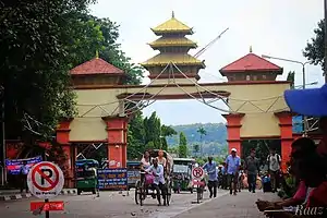 Nepal-India Border Gate at Kakarbhitta | |
 Kakarbhitta Location in Nepal | |
| Coordinates: 26°38′48″N 88°09′17″E | |
| Country | |
| Province | Province No. 1 |
| District | Jhapa |
| Elevation | 142 m (466 ft) |
| Population (1991) | |
| • Total | 21,366 |
| Time zone | UTC+5:45 (Nepal Time) |
Demographics
At the time of the 1991 Nepal census, Mechinagar had a population of 21,366 people living in 4147 individual households.[1]
Transport
Kakarbhitta is the eastern terminus of Nepal's east-west Mahendra Highway at the country's eastern border with Darjeeling District, West Bengal state, India. The Panitanki neighborhood of Batasi is on the other side. There is a border checkpoint for customs and third country nationals. Indian and Nepalese nationals cross without restriction.
Traffic between Nepal, India and Bangladesh goes through Kakarbhitta.[2]
Kakarbhitta is 21 kilometers from Bhadrapur airport (Nepal), 105 kilometers from Biratnagar airport (Nepal) and 21.5 kilometers from Bagdogra airport (India).
References
- "Nepal Census 2001". Nepal's Village Development Committees. Digital Himalaya. Archived from the original on 12 October 2008. Retrieved 24 November 2008.
- "Nepal to Seek 10,000 Cows from India". Kathmandu: The New Indian Express. IANS. 17 December 2014. Retrieved Aug 8, 2014.
| Wikivoyage has a travel guide for Kakarbhitta. |
Headquarter: Bhadrapur | ||
| Rural Municipalities | 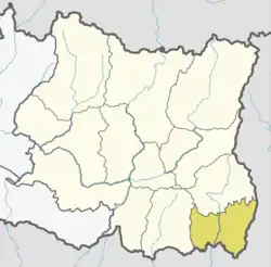 | |
| Municipalities | ||
