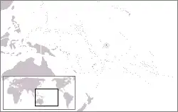
Kanton Island
Kanton Island (also known as Canton Island or Abariringa), previously known as "Mary Island", "Mary Balcout's Island" or "Swallow Island", is the largest, northernmost, and as of 2020, the sole inhabited island of the Phoenix Islands, in the Republic of Kiribati. It is an atoll located in the South Pacific Ocean roughly halfway between Hawaii and Fiji. The island is a narrow ribbon of land around a lagoon; an area of 40 square kilometers. Kanton's closest neighbour is the uninhabited Enderbury Island, 63 km to the south. The capital of Kiribati, South Tarawa, lies 1,765 km to the west. As of 2015, the population was 20, down from 61 in 2000.[1][2] The island's sole village is called Tebaronga.
| Native name: Abariringa | |
|---|---|
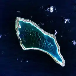 Kanton Island, visible color satellite image | |
 Kanton Island Canton Island 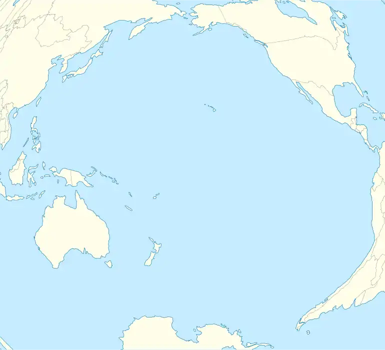 Kanton Island Canton Island | |
| Geography | |
| Location | Pacific Ocean |
| Coordinates | 02°48′38″S 171°40′32″W |
| Area | 9.2 km2 (3.6 sq mi) |
| Administrative division | Kanton |
| Largest Island settlement | Tebaronga (pop. 20) |
Kiribati declared the Phoenix Islands Protected Area in 2006, with the park being expanded in 2008. The 425,300 sq-km (164,200 sq-mi) marine reserve contains eight coral atolls, including Kanton.[3][4]
Discovery and toponomy of Kanton Island

On 5 August 1824, whaler Phœnix of London, master John Palmer, in the company of a whaler Mary of London, came to a low and barren island with a spacious lagoon in latitude 2° 48ʹ S and longitude 172° 10ʹ W, and it was named "Mary Ballcotts Island". H.E. Maude and Niel Gunson had both assumed it to be the whaler Mary owned by John Lydekker (1778–1832) and that her captain, Edward Reed Lacy, had reported the island. The entry for 5 August 1824, of that Mary's logbook, however, mentions no discovery, nor a ship Phœnix. The ship Mary truly there that day (her master presumably Abijah Lock) happened to be also a whaler from London, but was in fact owned by Hill, Boulcott & Hill, a firm that consisted of the two brothers James & Amon Hill and their brother-in-law John Ellerker Boulcott. He was married to a Mary Boulcott, née Hill, and it was she whom this island was named for. Ever since it was incorrectly penned down as "Mary Ballcotts Island" in William Dalton's journal it appeared with slightly deviating spelling-variants in books and on charts (Mary-Bulrock, Mary Balcout, Marie Ballcout, etc.) whereas it should have read "Mary Boulcott's Island" from the get-go.[5][6]
Modern Canton derives its name from the New Bedford whaler Canton, which was wrecked on its outer shore in early March 1854. Captain Andrew Johnson Wing (1820–1897) and his full crew managed to save not only themselves but also four small whaleboats and scanty provisions. In late March, the 31 men tried their luck by putting to sea in the four open boats and made their way northwest for 49 days straight when finally they reached safety in Guam, 2,900 nautical miles from where they had started.[7] Kanton is the writing in Gilbertese language of Canton (no C letter). The two versions of the name exist in the Constitution of 1979.
Geography, flora and fauna
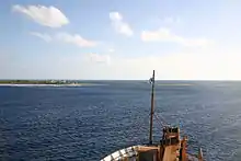
Kanton has been described as being shaped like a large pork chop.[8] From its northwest to southeast points is a distance of 14.5 km (9.0 mi), while the land rim varies in width from 50–600 m (160–2,000 ft) and 1.5–7 m (5–25 ft) in elevation. The southeast corner of the island is known as "Pyramid Point." The sole entrances to the lagoon are on the west side, with the main channel exhibiting currents of 6–8 knots (3–4 m/s).[9] The lagoon itself is filled with marine life, holding 153 different species of fish,[10] including tuna, sharks, stingrays and eels. An unpaved road runs around the island, though its current state of repair is uncertain. Canton Island Airport (IATA: CIS, ICAO: PCIS) lies at the northwest corner of the island, but it currently lacks any commercial scheduled service. The World Port Index number of Kanton Island is 56025.[11]
Much of Kanton's land surface is bare coral, sparsely covered with herbs and low bunch grass; trees and bushes are found near the village site. According to Edwin H. Bryan's American Polynesia and the Hawaiian Chain, Kanton possessed in 1941 a total of twelve native species of vegetation, including low herbs and bunch grass, a thick stand of Scaevola shrubs on the island's south side (2–3 m or 6.6–9.8 ft high), some Suriana maritima shrubs near the lagoon entrance, heliotrope (Heliotropium foertherianum) and kou (Cordia subcordata) trees, and coconut palms.[8][12] Geoffrey Buddle of the New Zealand solar eclipse expedition of 1937 reported 23 bird species on Kanton, together with Polynesian rats, lizards, hermit crabs and turtles. Two species of spiders were found on the island.[13]
.JPG.webp)
There is no freshwater on Kanton, which is a problem for settlers. Rainwater is caught in cisterns; Pan American had a large distillation plant on the island when it operated there during the 1940s and 50s. Rainfall is sparse, averaging 8.71–35.97 in (221–914 mm) between 1938 and 1953,[14] though later reports suggest a wetter climate in recent years.[15]
History
British claims
The British laid claim to Kanton Island during the 1850s.[8] The official British claim was formally reasserted on 6 August 1936, and an order in council issued in March 1937 including Kanton and other Phoenix Islands in the Gilbert and Ellice Islands Colony, with the British making several visits to the island culminating in the placement of two radio operators on Kanton on 31 August 1937.
Americans arrive
On 8 June 1937, Kanton was the site of a total solar eclipse and the island was occupied briefly by American and New Zealand scientists, members of an expedition organized by the National Geographic Society, and led by the astronomer Samuel Alfred Mitchell. During this time, the American party claimed the island for the United States, erecting a small monument with two American flags. According to one account, the British warship HMS Wellington fired a shot across the bow of the USS Avocet, when the latter refused to cede the choicest anchorage spot to the British vessel.[16] The American ship allegedly responded in kind, following which both captains agreed to "cease fire" until instructions could be received from their respective governments. Washington and London quickly ordered no further escalation, and both parties observed the solar eclipse together, "though officially a bit cool."[17]
In response to the British reoccupation of Kanton in August 1937, seven Americans from the American Equatorial Islands Colonization Project landed on the island on 7 March 1938. Although the British ambassador to the United States requested removal of markers claiming U.S. sovereignty, President Franklin Roosevelt formally placed the island under control of the U.S. Interior department on 3 March 1938. Both parties continued to press their competing claims until 6 April 1939, when the U.S. and Britain agreed to hold Kanton under joint control for the next fifty years as the Canton and Enderbury Islands condominium. The U.S./U.K. tenure proved cordial and cooperative thereafter, with each party enjoying the other's hospitality and working together to ensure smooth operation of island facilities. A United States office was open between 1940 and 1965 and from 1970.[18] Canton Island Post Office opened on 25 January 1941 and closed around February 1968.
Airplane oasis
Pan American World Airways (Pan Am) arrived on Kanton on 18 May 1939, to build facilities for their planned New Zealand flying boat service.[8] Service commenced on 12 July 1940 with the Boeing 314 Clipper. On 4 December 1941, the Pacific Clipper departed Kanton for New Caledonia as the final civilian flight before the United States joined the war.

World War II
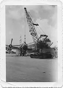
During World War II the United States Navy built a 6,230 foot (1.9 km) airstrip at 2°46′05″S 171°42′37″W (now known as Canton Island Airport (IATA: CIS, ICAO: PCIS)). Kanton became a stopover point for the Navy Air Transport Service flights to Australia and New Zealand as well as a staging point for attacks on the Gilbert Islands, then held by Japan. The SS President Taylor was grounded and abandoned near the island on 14 February 1942 when disembarking troops.[19] It was shelled three times in late 1942 by Japanese submarines, and bombed once on 25 March 1943. Damage was reported as "slight".[20] The island was defended by approximately 1,200 combat troops and support personnel, but was never attacked by Japanese forces.[21] It was the site of at least two airplane crashes during the war: on 19 July 1944 and 5 December 1945. After the war moved west, it became the homebase for the Roman Catholic chaplain in this area of the Pacific.[22]
Post War Administration and international airline service
In November 1946, Pan Am resumed service to Hawaii, Australia and New Zealand via Kanton with Douglas DC-4 aircraft. British Commonwealth Pacific Airlines (BCPA), Australia's first trans-Pacific airline, served the island via a cooperative agreement with Australian National Airways (ANA) initially with Douglas DC-4's on a routing of Sydney - Auckland - Fiji - Kanton Island - Honolulu - San Francisco - Vancouver, with the inaugural flight departing Australia on 15 September 1946. BCPA then began flying luxurious Douglas DC-6Bs on the Sydney to Vancouver route. Qantas took over this service shortly thereafter as BCPA subsequently ceased all operations and went out of business. Canadian Pacific Airlines also used the island as well for its Douglas DC-4 service between Vancouver and the southern hemisphere.[23] A full-scale community was established to support these airline operations, including an electrical power station, a hotel for the airline passengers' use, a medical dispensary, school for dependent children of station personnel, and other necessary facilities. The island was jointly administered by the United Kingdom and the United States, and the British and American post offices were both operated from a single building.
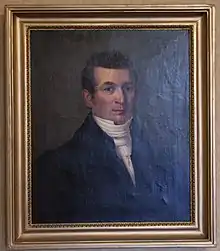
The American administrator, who was an employee of the Civil Aeronautics Administration (predecessor to the FAA) and island manager for that agency, also served as the U.S. resident administrator under the Department of the Interior and as a U.S. special deputy marshal under the Department of Justice. William J. Evans held this position from 1952 to 1955, during which time a crew from National Geographic magazine visited the island and highlighted it in the magazine's January 1955 issue.[24]
Vice-President Richard Nixon and his wife visited the island in October 1953, en route to New Zealand, where they stayed overnight and were interviewed by Fred Carpenter for the local radio station KIBS.[25][26] By 1956, Pan Am was operating a Boeing 377 Stratocruiser service into the airport from Los Angeles and San Francisco, via a stop in Honolulu, with these flights continuing on to Sydney with a stop at Nadi Airport in Fiji.[27]
Ultimately, the introduction of long-range jet aircraft spelled the end of Kanton's usefulness as an aircraft refueling station, and all airlines ended their operations there by the late 1950s—except for Pan Am, which continued a monthly service with Douglas DC-7C prop aircraft via Auckland, Nadi, Pago Pago, Kanton, Honolulu and return. This service was conducted using the outbased DC-7C aircraft N743PA and N744PA, which provided feeder service from Auckland to three points on the jet service schedules. The last Pan Am flight was in November 1965 when the final DC-7C returned to Miami after the opening of a new airport in Auckland, enabling New Zealand to be added to Pan Am's Boeing 707 jet routes. Kanton's airport remained operational, however, as an emergency landing field.
After the airlines
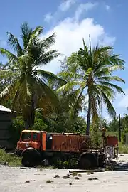
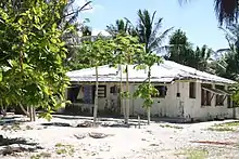
In 1960 a tracking station for the Mercury program was built on Kanton, and used through November 1965. The U.S. Air Force and the U.S. Space and Missile Systems Organization continued to use the island for missile-tracking operations through 1976. That year marked the complete end of the American presence; the airfield was abandoned and all U.S. personnel were removed.[28] The British closed their post office, ending their presence on Kanton as well. With the independence of Kiribati from Britain in 1979, the Anglo-American condominium was formally terminated, and the island transferred to Kiribati sovereignty. Kanton's post office was reopened by the Kiribati government, and the island was repopulated with a few people from the more crowded atolls of the Gilbert Islands, who reside in several of the abandoned residences left over from the Anglo-American presence.[29]
Kanton is occasionally visited by Republic of Kiribati vessels, the U.S. Coast Guard and various fishing boats. In 2008, Kanton and the rest of the Phoenix Islands became the Phoenix Islands Protected Area (PIPA), the world's largest marine protected area, covering a total area of 410,500 square kilometers of land and ocean.[30] In 2007 it was submitted, together with the rest of the PIPA, as a UNESCO World Heritage site.[31] A station of the Global Seismographic Network, IU KNTN, hosted by the Kiribati Weather Service was established in 2007 with current data shown as of August 2016.[32]
In 2010 Alex Bond and his yacht crew, who were sailing from Hawaii to Australia, stopped at Kanton and discovered the 24 islanders (14 adults and 10 children[33]) were dangerously short of food.[34] An expected supply ship had not arrived and they had been living on fish and coconuts for several months.[34] Bond said, "They have trouble growing what they need because of problems with the soil".[33] Bond contacted the UK Coastguard, who contacted the U.S. Coast Guard to arrange relief supplies.[33][34]
See also
Notes
- "Pacific Regional Statistics - Secretariat of the Pacific Community" (PDF). www.spc.int. Retrieved 4 June 2017.
- Morate, Orebwa (1 September 2016). "2015 Population and Housing Census" (PDF). Bairiki: National Statistics Office. Retrieved 21 January 2021.
- Howard, Brian Clark (16 June 2014). "Pacific nation bans fishing in one of world's largest marine parks". National Geographic News. Retrieved 15 May 2015.
- "Phoenix Islands Protected Area". Government of Kiribati. Retrieved 25 January 2015.
- Dehner, Steve (2019). THE ARMCHAIR NAVIGATOR I: Supplements to Post-Spanish Discoveries in The Pacific.
- Dalton, William (1990). The Dalton Journal. Two Whaling Voyages to the South Seas 1823-1829 (edited by Niel Gunson). Canberra: National Library of Australia. pp. 74–75. ISBN 9780642105059.
- Dehner, Steve (2019). The Armchair Navigator I.
- Resture, Jane. "Canton Island (Kanton - Abariringa) Phoenix Group, Kiribati". Retrieved 25 January 2015.
- Degener & Gillaspy, p. 2.
- http://www.pcrf.org/science/Canton/fishid.html.
- "World Port Index" (PDF).
- Bryan, p. 46.
- Degener & Gillaspy, pp. 47–48.
- Degener & Gillaspy, p. 5.
- http://www.tighar.org/Projects/Earhart/Bulletins/04_Kantonresults.html.
- Degener & Gillaspy, pp. 8–9.
- Degener & Gillaspy, p. 10.
- Premier Postal History. "Post Office List". Premier Postal Auctions. Retrieved 5 July 2013.
- "Pacific Wrecks". PacificWrecks.com. Retrieved 4 June 2017.
- Degener & Gillaspy, p. 11.
- "Account by Harold Mendelson, who was stationed on Canton during World War II".
- Flint, James (July 2008). "A Chaplain's Diary: Reverend Victor Laketer". Journal of Military History. 72 (3): 853–857. doi:10.1353/jmh.0.0014. S2CID 159945058.
- Degener & Gillaspy, p. 12.
- Walker, Howell (January 1955). "Air age grings life to Canton Island". The National Geographic Magazine. pp. 117–132.
- "RNZI Airs new Radio Heritage Feature - The Lost Nixon Tape - KIBS Canton Island 1953" (PDF). Radio Heritage Foundation. 8 October 2012. Retrieved 23 June 2013.
- "Sounds Historical - 16 June 2013 - Show Notes - 8:23 Mr and Mrs Nixon". Radio New Zealand. 16 June 2013. Retrieved 23 June 2013.
- "Pan American World Airways system timetable". 1 July 1956.
- http://www.tighar.org/TTracks/14_1/Kanton_Mission.html.
- "USCGC Kukui (WLB - 203)". www.uscg.mil. Retrieved 4 June 2017.
- "Phoenix Islands Protected Area (PIPA)". www.phoenixislands.org. Archived from the original on 10 August 2011. Retrieved 4 June 2017.
- "Unesco: Tentative entry for Phoenix Islands World Heritage Area".
- "Seismic Network Operations, IU KNTN, Kanton, Kiritibat (Site)". Global Seismographic Network. U.S. Geological Survey. Retrieved 20 January 2017.
- Morris, Steven (10 May 2010). "British sailor saves Kanton islanders from starvation". The Guardian. Retrieved 22 September 2019.
- "Kanton islanders resupplied thanks to Cornwall sailor". BBC News. 9 May 2010. Retrieved 9 May 2010.
References
 This article incorporates public domain material from the Air Force Historical Research Agency website http://www.afhra.af.mil/.
- Bryan, Edwin H., Jr. (1942). "American Polynesia and the Hawaiian Chain". Honolulu, HI: Tongg Publishing. p. 46.
- Dalton, William (1990). Gunson, Niel (ed.). The Dalton Journal: Two whaling voyages to the South seas, 1823–1829. [Sydney]: National Library of Australia. ISBN 0-642-10505-7..
- Degener, Otto; Gillaspy, Edwin (15 August 1955). "Canton Island, South Pacific". Atoll Research Bulletin. Washington, DC: The Pacific Science Board, National Academy of Sciences. 41: 1–51. doi:10.5479/si.00775630.41.1.
- Stackpole, Edouard A. The Sea Hunters: The New England whalemen during two centuries, 1635–1835.
External links
| Wikimedia Commons has media related to Kanton Island. |
- Kanton Atoll at the Encyclopædia Britannica
- History of the island
- Kanton Island Journey. Excellent photos from one woman's journey to Kanton and nearby islands in August 2008. Kanton photos start at the bottom of pg. 1, and continue on pg. 2.
- Phoenix Islands Website Contains information on Canton and the other Phoenix Islands.
- The Phoenix Islands National Geographic article on the Phoenix Islands, including information on Kanton.
- Kanton Island HAM Trip A HAM operator's trip to Kanton in 1999, including description of the island, village and islanders.
- C-130 Aircraft Overfly and Landing Brief footage from a C-130 flyover of Kanton in recent years, followed by an actual landing on its runway.
- The Phoenix Islands: An Annotated Chronology A chronological account of human activity in the Phoenix Islands, focusing especially on Kanton; includes several photos of the island, past and present.
| Gilbert Islands |  | |
|---|---|---|
| Phoenix Islands | ||
| Line Islands | ||
| West of Gilberts | ||
| Reefs | ||
| ||