Kedarnath
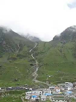
Kedarnath is a town in the Indian state of Uttarakhand and has gained importance because of Kedarnath Temple. It is a nagar panchayat in Rudraprayag district. The most remote of the four Chota Char Dham sites, Kedarnath is located in the Himalayas, about 3,583 m (11,755 ft) above sea level near Chorabari Glacier, the source of river Mandakini, and is flanked by snow-capped peaks, most prominently Kedarnath mountain. The nearest road head is at Gaurikund about 16kms away.
Kedarnath | |
|---|---|
Town | |
 Kedarnath | |
 Kedarnath Location in Uttarakhand, India  Kedarnath Kedarnath (India) | |
| Coordinates: 30°44′N 79°04′E | |
| Country | India |
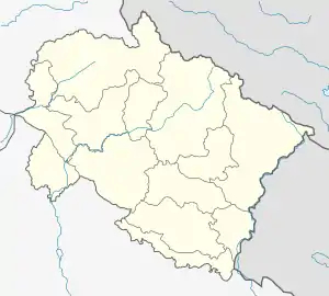
| State | Uttarakhand |
| Area | |
| • Total | 2.75 km2 (1.06 sq mi) |
| Elevation | 3,553 m (11,657 ft) |
| Population (2011) | |
| • Total | 612 |
| • Density | 220/km2 (580/sq mi) |
| Language | |
| • Official | Hindi[1] |
| • Additional official | Sanskrit[2][3] |
| Time zone | UTC+5:30 (IST) |
| Pin Code | 246445 |
| Vehicle registration | UK-13 |
| Website | uk |
The town suffered extensive destruction during June 2013 from flash floods caused by torrential rains in Uttarakhand state.
Etymology
The name "Kedarnath" means "the lord of the field". It is derived from the Sanskrit words kedara ("field") and natha ("lord"). The text Kashi Kedara Mahatmya states that it is so-called because "the crop of liberation" grows here.[4]
History
Kedarnath has been a pilgrimage centre since ancient times. It is not certain who constructed the original Kedarnath temple and when. A mythological account ascribes the temple's construction to the legendary Pandava brothers mentioned in the Mahabharata.[5][6] However, the Mahabharata does not mention any place called Kedarnath. One of the earliest references to Kedarnath occurs in the Skanda Purana (c. 7th-8th century), which names Kedara (Kedarnath) as the place where Shiva released the holy waters of Ganga from his matted hair, resulting in the formation of the Ganges river.[7]
According to the hagiographies based on Madhava's Sankshepa-Shankara-Vijaya, the 8th century philosopher Adi Shankara died near the Kedaranatha (Kedarnath) sanctuary; although other hagiographies, based on Anandagiri's Prachina-Shankara-Vijaya, state that he died at Kanchi. The ruins of a monument marking the purported resting place of Shankara are located at Kedarnath.[8] Kedarnath was definitely a prominent pilgrimage centre by the 12th century when it is mentioned in Kritya-kalpataru written by the Gahadavala minister Bhatta Lakshmidhara.[9]
Location

Kedarnath is located at a distance of 223 km from Rishikesh in Uttarakhand and close to the source of the Mandakini river at the height of 3,583 m (11,755 ft) above sea level.[10] The township is built on a barren stretch of land on the shores of Mandakini river. The surrounding scenery of Himalayas and green pastures makes it a very attractive place for pilgrimage and trekking. Behind the town and Kedarnath temple, stands the majestic Kedarnath peak 6,940 m (22,769 ft), Kedar Dome 6,831 m (22,411 ft) and other peaks of the range.[10][11]
Demographics
As of 2001 India census,[12] Kedarnath had a population of 479. Males constitute 98% of the population and females 2%. Kedarnath has an average literacy rate of 63%: male literacy is 63%, and female literacy is 36%. In Kedarnath, none of the population is under six years of age. The floating population from May to October every year is more than 5000 per day.
Climate
Kedarnath Temple is closed during the winter months due to snow. For six months, from November to April, the Palki with the Utsava Murti (Idol) of Lord Kedarnath is brought to a place called Ukhimath, near Guptakashi. Priests and other summertime residents also move their homes to nearby villages. Around 360 families of Tirtha Purohit of 55 villages and other nearby villages are dependent on Kedarnath for livelihood.
According to the Köppen-Geiger climate classification system, Kedarnath's climate is monsoon-influenced subarctic climate (Dwc), bordering a uniform rainfall subarctic climate (Dfc) with mild, rainy summers and cold, snowy winters.
| Climate data for Kedarnath, Uttarakhand | |||||||||||||
|---|---|---|---|---|---|---|---|---|---|---|---|---|---|
| Month | Jan | Feb | Mar | Apr | May | Jun | Jul | Aug | Sep | Oct | Nov | Dec | Year |
| Average high °C (°F) | 1.0 (33.8) |
2.4 (36.3) |
6.0 (42.8) |
10.8 (51.4) |
14.8 (58.6) |
17.1 (62.8) |
16.5 (61.7) |
15.9 (60.6) |
14.3 (57.7) |
10.6 (51.1) |
6.9 (44.4) |
3.7 (38.7) |
10.0 (50.0) |
| Daily mean °C (°F) | −3.7 (25.3) |
−2.3 (27.9) |
1.2 (34.2) |
5.6 (42.1) |
9.3 (48.7) |
11.9 (53.4) |
12.3 (54.1) |
12.0 (53.6) |
9.8 (49.6) |
5.3 (41.5) |
1.6 (34.9) |
−1.4 (29.5) |
5.1 (41.2) |
| Average low °C (°F) | −8.4 (16.9) |
−6.9 (19.6) |
−3.5 (25.7) |
0.5 (32.9) |
3.8 (38.8) |
6.8 (44.2) |
8.2 (46.8) |
8.1 (46.6) |
5.3 (41.5) |
0.1 (32.2) |
−3.6 (25.5) |
−6.5 (20.3) |
0.3 (32.6) |
| Average precipitation mm (inches) | 118.0 (4.65) |
101.0 (3.98) |
116.0 (4.57) |
63.0 (2.48) |
50.0 (1.97) |
75.0 (2.95) |
240.0 (9.45) |
234.0 (9.21) |
149.0 (5.87) |
57.0 (2.24) |
24.0 (0.94) |
51.0 (2.01) |
1,278 (50.32) |
| Source: [13] | |||||||||||||
2013 flash floods

On 16 June 2013, at approximately 7:30 p.m., a landslide occurred near Kedarnath Temple with loud thunder followed by the gushing of huge amount of waters from Chorabari Tal or Gandhi Tal down Mandakini River at about 8:30 p.m. which washed away everything in its path. On 17 June 2013 at approximately 6:40 a.m., waters rushed down from Chorabari Tal or Gandhi Sarovar, bringing along with its flow, a huge amount of silt, rocks, and boulders. A huge boulder got stuck behind Baba Kedarnath Temple, protecting it from the ravages of the flood's fury. The floodwater gushed on both sides of the temple, destroying everything in its path.[14][15] Thus in the middle of the pilgrimage season, torrential rains, cloud bursts, and resulting flash floods nearly destroyed the town of Kedarnath. The town was the worst affected area by the floods.[16] Thousands of people were killed, and thousands of others (mostly pilgrims) were reported missing or stranded due to landslides around Kedarnath. Although the surrounding area and compound of the Kedarnath temple were destroyed, the temple itself survived.[17][18] The rescue operation resulted in more than 100,000 people being airlifted with the help of mainly the Private Helicopter Operators, who began the rescue mission voluntarily without any clear directives from the State Government or the Ministry of Defence. The Indian Army and Indian Air Force helicopters arrived much after the Private Helicopter Operators had already begun the massive air-rescue mission. Dare-devil helicopter pilots, mostly ex-Indian Air Force and Ex-Army Aviation officers, flew relentlessly. Capt. Unni Krishnan from Prabhatam Aviation & Capt. Bhatnagar from Premair were few such outstanding pilots who landed at the Sh. Kedarnath Ji right-ridge at dusk hours - 1910hrs (almost 35 minutes after 'sunset') to pick-up the 'last' batch of survivors for the day. The NDRF represented by a commandant, and another junior officer arrived at the Sh. Kedarnath Ji 'right-ridge' unprepared with a malfunctioning satellite phone. However, the next day, they brought in more men and supplies. The first Indian Army officer to arrive at the Sh. Kedarnath Ji 'right-ridge' was a Captain from the Assam Rifles Regiment. He single-handedly displayed exemplary courage in rescuing many survivors by climbing up steep slopes and fractures along the Rambara ridge-line. His cool demeanor and stable poise, even under such intense and perilous circumstances, are proof of the impeccable training & discipline imbibed within him. The Indian Army later launched a massive rescue effort with thousands of its brave-heart men and vital equipment. The Indo-Tibetan Border Police and the reserve battalions of the Uttarakhand Police displayed outstanding courage in the rescue mission. A Eurocopter AS350 B3 helicopter, each, of the private helicopter operators - Prabhatam Aviation & Simm Samm Aviation, were lost during the rescue mission without any reported casualties. An Indian Air Force helicopter (Mi 17) also crashed during this exercise, killing all 20 people on board (all of them were soldiers involved in relief and rescue work). The Air Force dropped logs to build pyres for mass cremations of the victims.[16] It was reported that previously uncollected bodies were still being found one year after the tragedy.[19]
Places of interest
Other than Kedarnath temple, on the eastern side of the town is Bhairava temple,[10] and the deity of this temple, the Bhairava, is believed to protect the town during winter months. About 6 km upstream from the town, lies Chorabari Tal, a lake cum glacier also called Gandhi Sarovar.[10] Near Kedarnath, there is a cliff called Bhairav Jhamp.[10]
 Kedarnath in the 1860s
 Bhairavnath Ji considered as the protector of the area
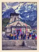 Darshan at Lord Kedarnath
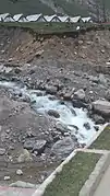 Water Fall
References
- "Report of the Commissioner for linguistic minorities: 50th report (July 2012 to June 2013)" (PDF). Commissioner for Linguistic Minorities, Ministry of Minority Affairs, Government of India. Archived from the original (PDF) on 8 July 2016. Retrieved 7 December 2020.
- Trivedi, Anupam (19 January 2010). "Sanskrit is second official language in Uttarakhand". Hindustan Times. Archived from the original on 1 February 2012. Retrieved 30 August 2017.
- "Sanskrit second official language of Uttarakhand". The Hindu. 21 January 2010. Archived from the original on 3 March 2018. Retrieved 30 August 2017.
- Diana L. Eck (2013). Banaras: City of Light. Knopf Doubleday. pp. 185–186. ISBN 978-0-307-83295-5.
- J. Gordon Melton; Martin Baumann, eds. (2010). Religions of the World: A Comprehensive Encyclopedia of Beliefs and Practices. 1 (A-B) (2nd ed.). ABC-CLIO. p. 1624. ISBN 978-1-59884-204-3.
- James G. Lochtefeld (2002). The Illustrated Encyclopedia of Hinduism: A-M. Rosen. pp. 363–364. ISBN 978-0-8239-3179-8.
- Alex McKay (2015). Kailas Histories: Renunciate Traditions and the Construction of Himalayan Sacred Geography. BRILL. p. 135. ISBN 978-90-04-30618-9.
- N. V. Isaeva (1993). Shankara and Indian Philosophy. SUNY Press. pp. 90–91. ISBN 978-0-7914-1282-4.
- Edward Quinn (2014). Critical Companion to George Orwell. Infobase. p. 232. ISBN 978-1-4381-0873-5.
- Abram, David (2003). The Rough guide to India (2003 ed.). New York: Rough Guides. pp. 354–355. ISBN 9781843530893.
- Kala, CP (2014). "Deluge, disaster and development in Uttarakhand Himalayan region of India: challenges and lessons for disaster management". International Journal of Disaster Risk Reduction. 8: 143–152. doi:10.1016/j.ijdrr.2014.03.002.
- "Census of India 2001: Data from the 2001 Census, including cities, villages and towns (Provisional)". Census Commission of India. Archived from the original on 16 June 2004. Retrieved 1 November 2008.
- "KEDARNATH CLIMATE". CLIMATE-DATA.ORG. Retrieved 5 May 2020.
- "[First-person Account] 'How I Survived 16 June Fury At Kedarnath' - Manoj Rawat - Tehelka - Investigations, Latest News, Politics, Analysis, Blogs, Culture, Photos, Videos, Podcasts". www.tehelka.com.
- "Uttarakhand floods: Survivors of Kedarnath recount ordeal".
- "High and wet". The Economist. 29 June 2013. Retrieved 14 November 2020.
- "Monsoon fury leaves Kedarnath shrine submerged in mud and slush". The Indian Express. 19 June 2013.
- "Thousands missing near Kedarnath shrine".
- "Exclusive: Dead bodies of pilgrims found in Kedarnath, one year after Uttarakhand tragedy", News Nation, 13 June 2014
- Dictionary of Hindu Lore and Legend (ISBN 0-500-51088-1) by Anna Dhallapiccola
External links
 Media related to Kedarnath at Wikimedia Commons
 Kedarnath travel guide from Wikivoyage
- Places and updates about Kedarnath valley
- Kedernath pilgrimage gets even tougher after last year's flood
| Deities |  | ||||||
|---|---|---|---|---|---|---|---|
| Texts | |||||||
| Mantra/Stotra | |||||||
| Philosophical traditions | |||||||
| Jyotirlingas | |||||||
| Temples |
| ||||||
| Traditional observances | |||||||
| |||||||