Kharagauli Municipality
Kharagauli (Georgian: ხარაგაულის მუნიციპალიტეტი) is a district of Georgia, in the region of Imereti. Its main town is Kharagauli. It has an area of 914 km². As of the 2014 census, its population was 29 688.
Kharagauli Municipality | |
|---|---|
 Surami pass railway tunnel | |
 Flag  Seal | |
 Location of the municipality within Georgia | |
| Country | |
| Region | Imereti |
| Capital | Kharagauli |
| Government | |
| • Mayor | Nikoloz Topuridze [1] |
| Area | |
| • Total | 914 km2 (353 sq mi) |
| Population (2002) | |
| • Total | 29 688 |
| • Density | 28.2/km2 (73/sq mi) |
| Time zone | UTC+4 (Georgian Standard Time) |
History
The historical territory of Kharagauli was part of the Margveti Saeristao. The "Silk Road" ran through here . During the feudal era, the present-day territory of Kharagauli was of strategic importance because of the roads connecting western and eastern Georgia. The historical monuments found here give grounds to assume that the Kharagauli area was a highly densely populated highway. This is evidenced by the ancestral tomb of the Pythians, which was found in the village of Bori. The places where now the town kharagauli located in the valley of the passengers resting place was leading caravans often rested in the Chkherimela valley wide open area. The territory of Kharagauli municipality has been inhabited since the Stone Age. On the right bank of the river Chkherimela , in the rock of Khandebi, a cave-human settlement of the Upper Paleolithic period , " Deviskhvreli ", has been found. During the feudal era , the territory of the municipality was of strategic importance, because the roads connecting western and eastern Georgia passed through it.
Vakhushti Batonishvili's description in "Kingdom of Georgia" indicates Kharagauli Fortress at this place, this fortress belonged to the Mamukashvili Abashidze And the location of the prison is unknown at this time. After the revolution, Kharagauli was changed to Ordzhonikidze. In honor of Sergo Orjonikidze, born in Ghoresha. "Orjonikidze district", This is how it was referred to during the Soviet regime, and after its demise it was renamed Kharagauli.
Until 1917, the territory of Kharagauli municipality was included in Shorapani Mazra of Kutaisi province . The settlement of Kharagauli appeared in the XIX century. In connection with the construction of the Poti-Tbilisi railway in the 70s. Since 1921 the territory of the municipality has been the administrative territory of the Georgian SSR . Territorial division The province hit, 1928-1929 years - The District, 1930 since the independent district in the form of continued existence. In 1932-1989 it was called Orjonikidze district. [2]
Economy
Industry was developed during the Soviet rule. There were Food processing, mining, timber, wine, dairy and furniture factories. The scale of the industry has shrunk considerably after the collapse of soviet Union. District industrial enterprises from notable bentwood furniture factories to mineral resources exploitation areas such as Marble (khoriti), granite (Vakha, Moliti), sabordiure, building stone and more. The district developed folk craft such as earthenware, pots, pitchers. Clay pottery and such. Tourism plays an important role in the economy of the municipality. This is facilitated by the Borjomi - Kharagauli National Park and the resort Nunisi , which is located on the territory of the municipality.
Tourism plays an important role in the economy of the municipality. This is facilitated by the Borjomi-Kharagauli National Park and the resort Nunisi , which is located on the territory of the municipality. The territory of the municipality plays a key role in the transport system of Georgia. It connects western and eastern Georgia with the Tsipi tunnel (3910 m.) And the Khandebi tunnel (740 m.). Georgian highway 1 and Khashuri-Samtredia railway section pass here. There are several railway stations on the territory of the municipality: Kharagauli, Moliti, Marelis, Tsipa. [3]
Agriculture
The main field for the district is agriculture. 1.5% of the total area of the municipality is used for agricultural purposes. In this area 70.9% is occupied by pastures, plowing and sowing suitable for 29.1% (annual crops occupy 22.5%, permanent crops - 22.5%, multi nargavebs - 6.6%) in agriculture are especially developed for breeding and Beekeeping . Municipal District of apiculture and the host fields of viticulture, Livestock.
Settlements
| Rank | Settlement | Population |
|---|---|---|
| 1 | Kharagauli | 1,965 |
| 2 | Ghoresha | 767 |
| 3 | Boriti | 557 |
Gallery
.jpg.webp)
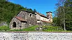 Ubisi Monastery
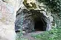 Deviskhvreli cave in Kharagauli
 Sergo Orjonikidze House Museum
See also
- Districts of Georgia (country)
External links
- Districts of Georgia, Statoids.com