Telavi Municipality
Telavi (Georgian: თელავის მუნიციპალიტეტი) is a municipality of Georgia, in the region of Kakheti. Its administrative centre is Telavi. Telavi is an important transportation hub, industrial, agricultural (winemaking) and cultural center of Eastern Georgia.
Telavi Municipality
თელავის მუნიციპალიტეტი | |
|---|---|
Municipality | |
 | |
 Flag  Seal | |
 Telavi Municipality | |
| Country | |
| Mkhare | Kakheti |
| capital city | Telavi |
| Government | |
| • mayor | Shota Nareklishvili [1] |
| Area | |
| • Total | 1,095 km2 (423 sq mi) |
| Population (2014) | |
| • Total | 38,721 |
| • Density | 35.38/km2 (91.6/sq mi) |
| Population by ethnicity[2] | |
| • Georgians | 86.5 % |
| • Azerbaijanis | 12.2 % |
| • Ossetians | 0.2 % |
| • Russians | 0.07 % |
| • Armenians | 0.01 % |
| Time zone | UTC+4 (Georgian Standard Time) |
| Website | http://telavi.gov.ge/ge |
Administrative divisions
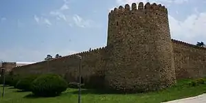
Ikalto-2008-01.jpg

Telavi Municipality consists of 27 administrative units - Central Telavi, Old Telavi, West Telavi, Alazani-Caucasus, East Telavi, Akura, Vanta, Busheti, Kvemo Khodasheni, Tsinandali, Kondoli, Kisiskhevi, Shalauri, Nasamkhrali, Gulgardi, Kurdghelari, Kurdghelari Ikalto, Karajala, Napareuli, Lapankuri, Laliskuri, Saniore - Jughaani, Artana, Pshaveli - Lechuri, Tetritsklebi.[3]
Settlements
| Rank | Settlement | Population |
|---|---|---|
| 1 | Telavi | 19 629 |
| 2 | Kurdghelauri | 3 962 |
| 3 | Tsinandali | 2 675 |
| 4 | Kondoli | 2 188 |
| 5 | Napareuli | 2,003 |
| 6 | Kisiskhevi | 1,916 |
| 7 | Akura | 1 869 |
| 8 | Pshaveli | 1 624 |
| 9 | Kvemo Khodasheni | 1 277 |
| 10 | Gulgula | 1 108 |
| 11 | Busheti | 1 090 |
| 12 | Lapanquri | 620 |
| 13 | Lalisquri | 499 |
| 14 | Akhateli | 271 |
Geography and climate

Telavi Municipality is bordered on the north and west by Akhmeta Municipality, on the northeast by the Republic of Dagestan, on the east by Kvareli Municipality, on the south-east by Gurjaani Municipality, and on the south-west by Sagarejo Municipality. A large part of the municipal lands is occupied by deciduous forests.
The territory of the municipality belongs to the district of moderately humid subtropical climate. The average annual air temperature is 12 °C, the amount of precipitation is 700-800 mm per year. The main hydrological artery of Telavi Municipality is formed by the Alazani River and its basin.
The central part of Telavi Municipality is spread on the Alazani plain and is bordered on the south-west by the Gombori ridge, and on the northeast by the Kakheti Caucasus. The highest peak of Gombori ridge is cold (1991 m) on the territory of Telavi municipality.[3]
Historical Landmarks
One of the architectural monuments in Telavi municipality is the Ikalto monastery complex, which was founded by one of the Assyrian fathers Zenon Ikaltoeli in the VI century. The old Shuamta Monastery is also noteworthy. The ensemble includes a 5th century basilica, a domed and a small domed church. In the 16th century, the old Shuamta Monastery was emptied. The daughter of Tinatin Gurieli, the wife of King Levan II of Kakheti, founded a new monastery near Shuamta near her. In the village of Kisiskhevi stands the ancient (VI-VII centuries) Church of the Mother of God. Mamadaviti Monastery is located near the village of Akura. Monuments of historical significance are also preserved in the village of Ruispiri.[4]
Historical sites include:
- Ikalto monastery complex
- Old Shuamta
- Alexander Chavchavadze House-Museum of Tsinandali
- Erekle II Palace (Telavi Historical-Ethnographic Museum)
References
- "მერი - თელავის მუნიციპალიტეტი". Telavi.gov.ge. Retrieved 2021-02-05.
- "Ethnic composition of Georgia 2014". Population statistics of Eastern Europe & former USSR (in Occitan). Retrieved 2021-02-05.
- "მდებარეობა, ბუნებრივი პირობები, მუნიციპალური ცენტრი - თელავის მუნიციპალიტეტი". Telavi.gov.ge. Retrieved 2021-02-05.
- "ისტორია - თელავის მუნიციპალიტეტი". Telavi.gov.ge. Retrieved 2021-02-05.
External links
- Districts of Georgia, Statoids.com
| Villages |
| |
|---|---|---|