Ozurgeti Municipality
Ozurgeti (Georgian: ოზურგეთის მუნიციპალიტეტი, Ozurgetis munitsipalit'et'i) is a district of Georgia, in the region of Guria. Its main town is Ozurgeti.
Ozurgeti Municipality | |
|---|---|
 School in Ozurgeti | |
 Flag  Seal | |
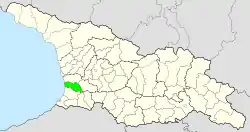 Location of the municipality within Georgia | |
| Coordinates: 41.9333°N 41.9833°E | |
| Country | |
| Region | Guria |
| Capital | Ozurgeti |
| Government | |
| • mayor | Konstantine Sharashenidze [1] |
| Area | |
| • Total | 675 km2 (261 sq mi) |
| Population (2002) | |
| • Total | 62,863 |
| • Density | 92.58/km2 (239.8/sq mi) |
| Population by ethnicity[2] | |
| • Georgians | 97.19 % |
| • Armenians | 1.77 % |
| • Russians | 0.59 % |
| • Ukrainians | 0.17 % |
| Time zone | UTC+4 (Georgian Standard Time) |
| Area code(s) | +995 496 |
| Website | ozurgeti |
Ozurgeti municipality is located on the territory of western Georgia. Its area is 643.07 km2 (248.29 sq mi). Ozurgeti municipality is bordered on the west by the Black Sea, on the south by the Adjara-Guria ridge, the Choloki River and the Autonomous Republic of Adjara; Chokhatauri municipalities in the east and Lanchkhuti municipalities in the north. Black earth-alluvial and earthen soils are spread in the territory of the municipality. Red earth soils are spread in the hilly strip of the municipality. Red alloys of alluvial secondary origin are developed on the terraces of rivers, sediments and swamps, and swampy soils are developed in the coastal zone.[3]
History
Until 1917, the territory of the municipality was included in Ozurgeti Mazra of Kutaisi Province, in 1930 it was formed as a separate territorial unit and was called Ozurgeti District. In 1934, Makharadze district was renamed in honor of Philip Makharadze. In the early 1960s, the area of the district was reduced: part of the area near Gomismti was transferred to Kobuleti district, and part of the area around the river Supsa to Lanchkhuti district. In 1963–64, Chokhatauri district joined Makharadze district and the city of Makharadze was defined as the center. In 1990, the district was renamed Ozurgeti, and since 2006 - Ozurgeti Municipality. In 2014, the city of Ozurgeti was separated from the municipality.[4]
Geography
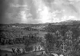
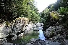
The territory of the municipality is flooded with rivers and valleys, the rivers belong to the Black Sea basin. The river Supsa flows in the territory of the municipality, to which the river Bakhvistskali joins the territory of the municipality. Also important are the sediments with tributaries: Bzhuzhi, Choloki, Bogila and others. The rivers of the municipality are fed by lanyards, rains, soil water and springs. At the confluence of the seas they contribute to the marshes of the lowlands. The river Choloki separates Ozurgeti municipality from the territory of Kobuleti municipality. The rivers are rich in fish. Found in trout, barbel, salmon, sorrel. The highest points of the territory of the municipality are in the south-eastern part of its border. Here are the highest peaks of the municipality: Mount Sakornia (2,756 m [9,042 ft].) And Gunistavi (2,132 m [6,995 ft]). The south-western part of the municipality is a plain, which is a floodplain of the river Natanebi, with an average height of 20 metres (66 ft) above sea level. Achi water gorge North of Vake is the southwestern end of the Guria Mountains, where the average altitude is 120 metres (390 ft) above sea level. It is located here near Mount Jacob, which is 145 metres (476 ft) high.[5]
Climate
The climate is characterized by subtropical humid climate. Humidity is due to the proximity of the Black Sea and high ridges to the east. Humidity is especially high in summer. The average annual rainfall is 2,100 to 2,800 mm (83 to 110 in). The maximum precipitation falls in September, the minimum - in May. The average annual air temperature is 14.5 to −4 °C (58.1 to 24.8 °F), the coldest month is January (+5 to −5 °C [41 to 23 °F]), and the warmest is August (23 to 13 °C [73 to 55 °F]). The absolute minimum temperatures are −17 to −18 °C (1 to 0 °F) (coastal lowlands) and −30 to −32 °C (−22 to −26 °F) (high mountains). The absolute maximum ranges between 31 and 41 °C. The territory of the municipality is characterized by seasonal winds: south-east winds in winter and west winds in summer. The average wind speed is 3.2 m/s (10 ft/s). Knows fions in winter and spring, though they do less harm; Than in other parts of western Georgia. The territory of the municipality is in the 5-6 magnitude zone in terms of earthquake danger.[6]
Biodiversity
The forest occupies 17,021 hectares (42,060 acres) on the territory of the municipality. The vegetation is formed by chestnut, hornbeam, beech, dried fruit, in the form of undergrowth can be found blueberries, sage, watercress. Natural forests are preserved in the south-eastern highlands of the municipality. At 700 to 1,700 m (2,300 to 5,600 ft) above sea level, there is a deciduous forest (alder, hornbeam, beech), and at 1,700 to 2,100 m (5,600 to 6,900 ft) there is a coniferous forest (pine, fir, spruce). Bears, roe deer, marten, tortoises, lynxes, squirrels, wolves, ticks, hedgehogs, badgers, rabbits, rabbits are common in the forests. Among the birds common are dzera, kvavi, orbi, thrush, chkhartvi, wild duck, swamp hen, niblia, kodala, tavshava, heartworm, hawk. Migratory birds enter in spring: ghazo, jadon, quail, hoopoe, mullet.
Population
The population according to the 2002 census was 77,200 thousand people; The population was 84,126 at the 2010 census.
In 2014, after the city of Ozurgeti was separated from the municipality, its population is about 63 thousand people. 96% of them are Georgians, mainly Gurians, as well as Adjarans. There are also Armenians (2%) and Russians (1%). The vast majority of the population is Orthodox Christian, a small portion is Muslim, and there are small groups of other religious denominations living in the municipality: Jehovah's Witnesses at City Hall and members of the Mes's Orthodox Church in Georgia (Boston Group).
There are 73 settlements in the municipality. Density - 98.58 inhabitants per square kilometre (255.3/sq mi).[7]
Settlements

| Rank | Settlement | Population |
|---|---|---|
| 1 | Ozurgeti | 14 785 |
| 2 | Kveda Nasakirali | 2 898 |
| 3 | Naruja | 2 148 |
| 4 | Gomismta | 2 020 |
| 5 | Ureki | 1 166 |
| 6 | Shemokmedi | 1 322 |
| 7 | Chala | 408 |
| 8 | Shekvetili | 175 |
Historical sites
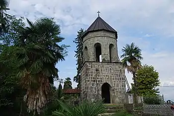
The oldest historical monument on the territory of the municipality is the town of Vashnari. There are two castles on the territory of the municipality and both are named after Queen Tamar. These are the castles of Askani and Likhauri. Askani Castle Among the medieval church buildings are the Church of the Creator, which is the center of the Diocese of the Creator, and the Church of Jumat, which was the historic center of the Diocese of Jumat. Important monuments are the churches of Achi, Likhauri and Baileti, where rare frescoes are preserved. In addition, hall and basilica type churches are located in Dvabzu, Vaniskedi, Kviriketi, Meria, Mtispiri, Konchkati and Khrialeti.[8]
Historical sites include:
Resorts and tourism

Ozurgeti Municipality has unique resorts both on the seaside and in the alpine zone. Of the four recreational status resorts in Georgia, Ureki is located in the municipality. The resorts of the municipality allow to host tourists from Georgia or abroad in winter and summer, which is one of the main preconditions for budget growth and employment of the population. Ureki, Shekvetili and Gomismta mountain resort are among the seaside resorts of the municipality.[9]
Resorts and Tourist sites include:
- Ureki
- Shekvetili
- Nasakirali
- Black Sea Arena
- Ozurgeti Drama Theatre
- Ozurgeti History Museum
- Shekvetili Miniature Park
- Dimitri Gurieli Palace
References
- http://ozurgeti.mun.gov.ge/?page_id=343
- http://pop-stat.mashke.org/georgia-ethnic-loc2014.htm
- http://ozurgeti.mun.gov.ge/?page_id=293
- http://ozurgeti.mun.gov.ge/?page_id=293
- http://ozurgeti.mun.gov.ge/?page_id=293
- http://ozurgeti.mun.gov.ge/?page_id=293
- http://ozurgeti.mun.gov.ge/?page_id=293
- http://ozurgeti.mun.gov.ge/?page_id=195
- http://ozurgeti.mun.gov.ge/?page_id=195
External links
- Districts of Georgia, Statoids.com