Khndzoresk
Khndzoresk (Armenian: Խնձորեսկ, pronounced [χəndzɔˈɾɛsk]) is a village in the Goris Municipality of the Syunik Province in Armenia. The village is located to the east of the Goris-Stepanakert highway, on the steep slopes of Khor Dzor (Deep Gorge), which the village is named after, according to tradition.
Khndzoresk
Խնձորեսկ | |
|---|---|
 The caves of Khndzoresk | |
 Khndzoresk | |
| Coordinates: 39°30′44″N 46°26′01″E | |
| Country | |
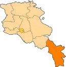
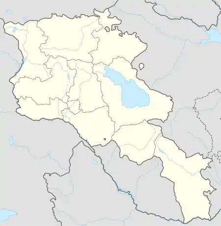
| Province | Syunik |
| Municipality | Goris |
| Area | |
| • Total | 67.86 km2 (26.20 sq mi) |
| Population | |
| • Total | 2,070 |
| • Density | 31/km2 (79/sq mi) |
| Time zone | UTC+4 (AMT) |
| Khndzoresk at GEOnet Names Server | |
Crossing the bridge at the entrance of the village, the road continues towards the towns of Lachin and Stepanakert. New Khndzoresk (the current inhabited area) was built in the 1950s. The village is located at 1580m above sea level and occupies 6772,8ha.
Demographics
Population
The National Statistical Service of the Republic of Armenia (ARMSTAT) reported its population as 2,260 in 2010,[3] up from 1,992 at the 2001 census.[4] In 2009, the population of Khndzoresk comprised 2256 people, of which 1126 were women and 1130 were men. There were 516 households in total.
History
.jpg.webp)
In the end of the 19th century Old Khndzoresk was the biggest village of Eastern Armenia. In the beginning of the 20th century the community had 8300 inhabitants (1800 households). In 1913 there were 27 shops, 3 dye-houses, tanneries, 7 schools. The village is famous for taking part in the liberation movement of David Bek. The fortress of Khndzoresk served as a military base for Mkhitar Sparapet in 1728-1730. In 1735 the village was visited by Catholicos (Head of Armenian Apostolic Church) Abraham Kretatsi who gave a thorough description of the community in his chronicles. During the 1980s, an additional village sprouted 7km from Khndzoresk due to resizing and political unrest. This village, considerably smaller than Khndzoresk, is called Lower Khndzoresk, or Nerkin Khndzoresk.
Cultural heritage
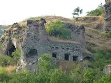
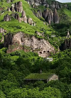
Khndzoresk is widely famous for its canyon with picturesque rock formations and ancient cave settlement. The artificial caves, some of which are currently used as stables and warehouses, used to be inhabited till the 1950s. In the bottom of the gorge there is St. Hripsime church, dated back to 17th century. On a spur beyond on the right side of the gorge there is Anapat (hermitage) with the tomb of Mkhitar Sparapet. The cave church of St.Tatevos can also be found nearby.
Economy and culture
About 90% of the population is involved in agriculture (animal husbandry and gardening). There is a small milk processing enterprise, employing 8 people. The community has a number of administrative and public institutions, such as a community council, a secondary school (with 370 pupils), a musical school, a kindergarten, a library, a museum and a culture club.[5]
Climate
The climate in the community is warm, relatively humid, with mild winters. Annual precipitation is 450-700mm.
Genetics
Surprisingly, most of the villagers have been found to belong to Y-DNA Haplogroup R1b, specifically to a Western European branch of L754 > L389 > P297 > M269 > L23 > L51 > L52 > L151 > P312 > DF27 > Y3267 > Y7365 > Y28672 > Y7363 > Y41095 > Y41710 > Y42667.[6] Closest Europeans from France. As of march 2020 the closest common ancestor of these French and Khndzoresk people lived about 1050 years ago.[7] Origins are being explored in a Y-DNA project with the company FamilyTreeDNA.[8]
References
| Wikimedia Commons has media related to Khndzoresk. |
- "Syunik regional e-Governance System" (in Armenian). Syunik Province provincial government. Click on link entitled "Համայնքներ" (community) and search for the place by Armenian name.
- Statistical Committee of Armenia. "The results of the 2011 Population Census of the Republic of Armenia" (PDF).
- "Marzes of Armenia and Yerevan City in Figures, 2010" (PDF). Statistical Committee of Armenia.
- Report of the results of the 2001 Armenian Census, Statistical Committee of Armenia
- S. Hayrapetyan. Four-Year Development Programme of Khndzoresk Community (2009-2012). 2009
- https://yfull.com/tree/R-Y42667/
- https://yfull.com/tree/R-Y41710/)
- https://www.familytreedna.com/groups/khndzoresk-dna-project/