Killamarsh
Killamarsh is a town and civil parish in North East Derbyshire, England, bordering Sheffield and South Yorkshire to the North West. Killamarsh is surrounded by, in a clockwise direction from the north, Rother Valley Country Park, Wales, Kiveton, Woodall, Harthill, Barlborough, Spinkhill, Renishaw, Eckington, and the (former Derbyshire) Sheffield suburbs of Oxclose, Halfway and Holbrook.
| Killamarsh | |
|---|---|
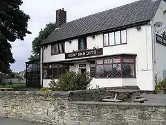
 West End Hotel, Killamarsh | |
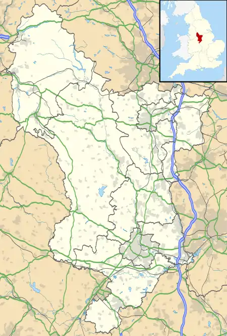
 Killamarsh Location within Derbyshire | |
| Population | 9,445 (civil parish, 2011)[1] |
| OS grid reference | SK458806 |
| Civil parish |
|
| District | |
| Shire county | |
| Region | |
| Country | England |
| Sovereign state | United Kingdom |
| Post town | SHEFFIELD |
| Postcode district | S21 |
| Dialling code | 0114 |
| Police | Derbyshire |
| Fire | Derbyshire |
| Ambulance | East Midlands |
| UK Parliament | |
Killamarsh was mentioned in the Domesday Book with the name Chinewoldemaresc or Chinewolde[2] meaning "Cynewalds Marsh". There are a number of smaller communities within the town; Norwood, Nethergreen, Westthorpe and Upperthorpe surround the main town centre.
History
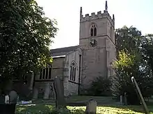
The parish church of St. Giles contains gravestones dating back to the Saxon era as well as masonry work from the 12th century, and many stained glass windows. A number of public houses in Killamarsh are over 300 years old. Domesday records Killamarsh as belonging to Hascoit Musard and being valued at 12 pence.[2]
Economy
The community originally grew from a farming community, self-sufficient in agricultural and dairy produce since the Middle Ages. In the 19th and 20th centuries, Killamarsh became a thriving mining town as the burgeoning Sheffield iron industry demanded coal and transport links with Sheffield matured. Coal has been mined in Killamarsh since at least the 15th century, but the first major mining operation opened at Norwood resulting in an almost doubling of the Killamarsh population between 1861 and 1871. The last two "pits", Westthorpe and High Moor, are now gone, casualties of the early 1980s pit closure programme.
The river Rother which flanks Killamarsh had provided power to grain mills since the earliest times and was used by ironmongers and smiths from the late 18th century. [3] Killamarsh Forge was owned and operated by Webster & Horsfall. They made crucible steel which was cast into ingots. These were then shipped to their Penns Mill plant in Walmley who drew the special wire. This was used in the core of the 2nd trans-Atlantic telegraph cable laid by the SS Great Eastern in 1866 as well as other equipment used in the splicing operations.
There is an industrial estate located in the Norwood area north of the town and light industrial units and a business innovation centre to the south on the site of the old Westthorpe Colliery. To the west of Killamarsh is a small animal feed mill, and the factory of Ross and Catherall, a specialist alloys supplier to the aerospace industry.
Composition and geography
Killamarsh is situated on the eastern side of the Rother Valley. The centre of Killamarsh can be defined as the junction where Bridge Street meets Sheffield Road, from which point the roads spawn to all other areas of the town. The surrounding area which contains the shops and businesses on Sheffield Road and Bridge Street are commonly known as The Village by locals (In a similar style to how Sheffield City Centre is referred to as Town by the city's residents). Progressing southwards up Sheepcote Hill and the communities of Upperthorpe and Westthorpe lie to the east and south east. In earlier times these were distinctively separate from the village centre but it is now difficult to define where the boundaries between the three actually are. To the west of the centre is Netherthorpe, which encompasses the area around the former railway lines and the new-build estates around Walford Road. The centre to south west of Killamarsh is dominated by housing estates built post-war and in the later half of the 20th century. The Rowan Tree Road area contains roads of mostly semidetached builds on roads which are named primarily after trees. Killamarsh's estate of pre-fabricated mostly council homes - dubbed the "White City", is adjacent. Norwood is in the north of the town and surrounds the main road which leads to Waleswood. Between this and Upperthorpe is Church Town and Nether Green, which surround the Kirkcroft Lane area. Out on the far eastern boundaries is High Moor, which due to its significant distance from the rest of Killamarsh is often described as a village in its own right.
Transport
Killamarsh is roughly the same distance to the centres of Sheffield, Chesterfield and Rotherham. Sheffield became the dominant connecting city as its burgeoning iron and steel industry demanded coal, and the road between Killamarsh and Sheffield was upgraded.
Road
The main trunk route into Killamarsh is the B6058 (Station Road / Sheffield Road) which connects the town centre to the A6153 In Mosborough via Halfway, and the A618 at Norwood Roundabout. The A618 then runs south through High Moor towards Clowne, and north through Norwood towards the A57 at Aston. A handful of rural roads connect Killamarsh to the A6153 at Renishaw via Spinkhill. Other notable main roads in Killamarsh include Bridge Street, which runs through the heart of Killamarsh's commercial area, and Walford Road / Rowan Tree Road, which skirt the bulk of the town's residential area.
Killamarsh is roughly equidistant to junctions 30 (Barlborough) and 31 (Aston) of the M1.

Bus and tram
Killamarsh is served by public transport. It is served by 2 services operated by Stagecoach in Chesterfield with 3 services operated by Stagecoach Yorkshire and 1 service operated by TM Travel. There are hourly services to Chesterfield in the form of the 80/80A which is an extension of the 80 bus to Brimington from Chesterfield as one bus an hour is extended from Brimington to Sheffield via Staveley, Killamarsh and Crystal Peaks. There are other services to Crystal Peaks and Thorpe Salvin with the 26/26A and Crystal Peaks to Clowne with the 74. TM Travel also operate a service, the X30 to Sheffield, once in the morning. Killamarsh used to have a service which went to Dinnington and Rotherham, First South Yorkshire's 27 which was cut back in the early 2010s. Killamarsh is also served by the 627 Rotherham - Kiveton Park, weekdays and only in school time.
Rail
Killamarsh is no longer served by passenger rail transport, but before the Second World War, three railway lines made their way through the west side of the town, with three stations. These were, Killamarsh West (opened 1841), on the Midland Railway's Old Road route which bypassed Sheffield, Killamarsh Central (opened 1892), on the Great Central Railway's mainline from London to Manchester, and Upperthorpe and Killamarsh (opened 1898), on the LD&ECR's Beighton Branch into Sheffield. Upperthorpe and Killamarsh was the first station to close in 1930 after just 32 years of service, with the line itself closing with the outbreak of war nine years later. Post war, and in 1954 Killamarsh West Closed, with Killamarsh Central remaining open until 1963 when it too was closed, both stations victims of British Railways' vast closure schemes during this period. The track through the former Great Central line was eventually lifted in the early 1980s, and today forms part of the Trans Pennine Trail. The LD&ECR's route remains derelict to this day, complete with abandoned ballast and signalling cables. The Midland's Old Road route remains open to freight traffic, and has been the subject of debate in recent times over the possibility of reopening a station for Killamarsh on the Line.
The western side of Killamarsh was going to be significantly affected by the new HS2 route from Birmingham to Leeds, but following the government's favouring of an alternative route which will run parallel to the M1 motorway, this no longer likely to be the case.
Cycling
Killamarsh is one of the beneficiaries of the Sustrans Connect2 project for creating cycle routes.[4] The project has now drawn to a close with the final erection of two new pedestrian and cycle bridges crossing the River Rother and the railway on the border of NE Derbyshire and Sheffield.
Chesterfield Canal
The Chesterfield Canal passed through the town on its way to Kiveton via the Norwood Tunnel, which was the joint longest canal tunnel in the UK at the time of its construction.[5] The canal fell into disrepair following the collapse of the tunnel in 1907. The remains of the Chesterfield Canal are present but housing has been built on part of the canal's original route, and the undeveloped sections are mostly public footpaths. Work carried out in 2008 to create the Killamarsh Greenway brought large sections of the original canal towpath back into use as a traffic-free route through the town, with the intention that once restoration is complete, a significant section of the towpath will already be in a usable state. The canal has been restored from the Chesterfield end as far as Staveley. Work is ongoing to extend it towards Killamarsh with a new route proposed to bypass the missing section and link up to the existing canal at Kiveton. The planned new route will take in part of the old line of the canal and introduce some new sections including taking the canal in to Rother Valley Park before rejoining the original line for the ascent through Norwood.
The planned Rother Link will connect the Chesterfield Canal at Killamarsh, via the River Rother through to the Sheffield and South Yorkshire Navigation, thus creating a new cruising ring and encouraging boats to visit the Chesterfield Canal.
Facilities
Killamarsh has a library, medical centre, shopping areas, and newsagents. It also has good connections to local major towns by virtue of regular bus services and its location close to the Halfway terminus of the Sheffield Supertram network.
Public houses and social clubs
Until the 2000s Killamarsh had ten public houses, but four have closed in recent years. The pubs in Killamarsh today are The Midland on Sheffield Road, the Steelmelters on Netherthorpe Lane, The Crown Inn on Ashley Lane, the Travellers Rest on Mansfield Road, The Nags Head on Westthorpe Road, and the West End Hotel also on Westthorpe Road. There are two social cubs in the town, The Juniors Athletics Club and The Nether Green WMC, both on Sheffield Road. The Parish Pump bar located within the Sports Centre is also open to the public during weekday evenings.
Rother Valley Park
Rother Valley Country Park lies to the north of the town. It was created in the early 1980s as part of the restoration works following open cast mining of the area. Originally managed by a joint board of Sheffield MBC, Rotherham MBC, South Yorkshire MCC and Derbyshire CC, the park is now wholly managed by Rotherham. The scheme created a series of ponds and lakes, with the surrounding area landscaped to form a nature reserve[6] and recreation areas, with facilities for water sports. The River Rother flows from the west of town and passes through the centre of the park.
New Leisure Park
The adjacent land to the north-east of Rother Valley Country Park was also open cast following the closure of the Beighton Pit. On that site, there was a proposal in 2003 to build a large leisure-related development called the YES! project, but two years into the seven-year plans of Oak Holdings was pulled due to lack of progress. It was then awarded to Visions Of China who proposed a Chinese leisure development on the site in 2011. The site falls on the border between South Yorkshire and Derbyshire.
Notable residents
- Lee Askham, footballer, who played for Chesterfield F.C., born here.
- Millie Bright, footballer, who has played for Doncaster Belles, Chelsea and England.
- Fred Greaves, the first Derbyshire person to get a Victoria Cross was born here in 1890.[7]
- Richard Hinds grew up in Killamarsh and was a member of the first team squad at Sheffield Wednesday Football Club from 2007 - 2011.
- Sidney Smith, professional billiards and snooker player who was born in Killamarsh in 1908.[8]
- Nicky Weaver grew up in Killamarsh before joining Mansfield Town's youth academy, signed by Manchester City, stepping up to the first team, where he played over 200 games. After groundbreaking surgery following a long term knee injury, part of his rehabilitation was going on loan to his favourite team Sheffield Wednesday before joining Charlton Athletic, Dundee United and a short term contract with Burnley. Nicky turned down a Championship club and signed for his boyhood favourites, Sheffield Wednesday.
Local street names
Brindley Court after James Brindley, builder of the Chesterfield Canal that navigates through Killamarsh and opened in 1777.
Nethergreen Court adjacent to the Nethergreen WMC and on the site of a tennis court.
Powell Drive after the Rev'd Septimus Powell, rector circa 1914.
Baker Drive after Councillor Thomas Edward Baker .
Sports teams
Killamarsh has many sports teams, in senior and junior age groups. The Killamarsh Dynamoes Athletic Football Club (KDAFC) is one of the many junior footballing sides in the area. Killamarsh Khaos Skater Hockey Club (KSHC) is a roller hockey club with age groups spanning from U10 (U12, U14, etc.) up to senior level. Killamarsh Juniors Athletic Club Institute hosts senior and junior football on its grounds as well as the Killamarsh Juniors Cricket Club (KJCC), which has age groups from U11 to three senior sides and a Sunday side.
See also
References
- "Neighbourhood Statistics". Office for National Statistics. Retrieved 3 January 2015.
- Domesday Book: A Complete Translation. London: Penguin, 2003. ISBN 0-14-143994-7 p.753 and 1365
- The Iron Men of Penns by John Horsfall
- Killamarsh area
- Richardson, Christine (2009). Norwood Tunnel: Four Centuries of Challenge. Richlow Histories. ISBN 978-0-9552609-6-4.
- Rother Valley Bird photos Archived 19 February 2010 at the Wayback Machine, Retrieved 2 February 2010
- Derbyshire at VictoriaCross.org Archived 17 July 2007 at the Wayback Machine Retrieved 18 June 2007
- Andy Hunter on the Cue Collector website http://www.thecuecollector.com/files/CueCollectorArticles/Hunter_Article_16__Sidney_Smith_.pdf Retrieved 7 December 2011
