List of civil parishes in Derbyshire
This is a list of civil parishes in the ceremonial county of Derbyshire, England. The districts are shown to the right and are numbered as follows:-
- 1 High Peak
- 2 Derbyshire Dales
- 3 South Derbyshire
- 4 Erewash
- 5 Amber Valley
- 6 North East Derbyshire
- 7 Chesterfield
- 8 Bolsover
- 9 Derby
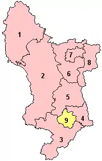
Click on image
Amber Valley
Part of the former Alfreton Urban District is unparished.
- Alfreton (town)[lower-alpha 3]
- Ashleyhay[lower-alpha 2]
- Belper (town)[lower-alpha 4]
- Codnor[lower-alpha 1]
- Crich[lower-alpha 2]
- Denby[lower-alpha 2]
- Dethick, Lea and Holloway[lower-alpha 2]
- Duffield[lower-alpha 2]
- Hazelwood[lower-alpha 2]
- Heanor and Loscoe (town)[lower-alpha 1]
- Holbrook[lower-alpha 2]
- Horsley[lower-alpha 2]
- Horsley Woodhouse[lower-alpha 2]
- Idridgehay and Alton[lower-alpha 2]
- Ironville[lower-alpha 3]
- Kedleston[lower-alpha 2]
- Kilburn[lower-alpha 2]
- Kirk Langley[lower-alpha 2]
- Mackworth[lower-alpha 2]
- Mapperley[lower-alpha 2]
- Pentrich[lower-alpha 2]
- Quarndon[lower-alpha 2]
- Ravensdale Park[lower-alpha 2]
- Ripley (town)[lower-alpha 5]
- Shipley[lower-alpha 2]
- Shottle and Postern[lower-alpha 2]
- Smalley[lower-alpha 2]
- Somercotes[lower-alpha 3]
- South Wingfield[lower-alpha 2]
- Swanwick[lower-alpha 3]
- Turnditch[lower-alpha 2]
- Weston Underwood[lower-alpha 2]
- Windley[lower-alpha 2]
Bolsover
The whole of the district is parished.
- Ault Hucknall[lower-alpha 6]
- Barlborough[lower-alpha 7]
- Blackwell[lower-alpha 6]
- Clowne[lower-alpha 7]
- Elmton with Creswell[lower-alpha 7]
- Glapwell[lower-alpha 6]
- Hodthorpe and Belph
- Langwith[8][lower-alpha 6]
- Old Bolsover (town)[lower-alpha 8]
- Pinxton[lower-alpha 6]
- Pleasley[lower-alpha 6]
- Scarcliffe[lower-alpha 6]
- Shirebrook (town)[lower-alpha 6]
- South Normanton[lower-alpha 6]
- Tibshelf[lower-alpha 6]
- Whitwell[lower-alpha 7]
Chesterfield
The former Chesterfield Municipal Borough is unparished.[10]
Derby
The former Derby County Borough is unparished.[13]
Derbyshire Dales
The whole of the district is parished.
- Ashbourne (town)[lower-alpha 13]
- Ashford in the Water[lower-alpha 11]
- Atlow[lower-alpha 12]
- Bakewell (town)[lower-alpha 14]
- Ballidon[lower-alpha 12]
- Baslow and Bubnell[lower-alpha 11]
- Beeley[lower-alpha 11]
- Biggin[lower-alpha 12]
- Birchover[lower-alpha 11]
- Blackwell in the Peak[lower-alpha 11]
- Bonsall[lower-alpha 15]
- Boylestone[lower-alpha 12]
- Bradbourne[lower-alpha 12]
- Bradley[lower-alpha 12]
- Bradwell[lower-alpha 11]
- Brailsford[lower-alpha 12]
- Brassington[lower-alpha 12]
- Brushfield[lower-alpha 11]
- Callow[lower-alpha 12]
- Calver[lower-alpha 11]
- Carsington[lower-alpha 12]
- Chatsworth[lower-alpha 11]
- Chelmorton[lower-alpha 11]
- Clifton and Compton[lower-alpha 12]
- Cromford[lower-alpha 15]
- Cubley[lower-alpha 12]
- Curbar[lower-alpha 11]
- Darley Dale (town)[lower-alpha 15]
- Doveridge[lower-alpha 12]
- Eaton and Alsop[lower-alpha 12]
- Edensor[lower-alpha 11]
- Edlaston and Wyaston[lower-alpha 12]
- Elton[lower-alpha 11]
- Eyam[lower-alpha 11]
- Fenny Bentley[lower-alpha 12]
- Flagg[lower-alpha 11]
- Foolow[lower-alpha 11]
- Frogatt[lower-alpha 11]
- Gratton[lower-alpha 11]
- Great Hucklow[lower-alpha 11]
- Great Longstone[lower-alpha 11]
- Grindleford[lower-alpha 11]
- Grindlow[lower-alpha 11]
- Harthill[lower-alpha 11]
- Hartington Middle Quarter[lower-alpha 11]
- Hartington Nether Quarter[lower-alpha 12]
- Hartington Town Quarter[lower-alpha 12]
- Hassop[lower-alpha 11]
- Hathersage[lower-alpha 11]
- Hazlebadge[lower-alpha 11]
- Highlow[lower-alpha 11]
- Hognaston[lower-alpha 12]
- Hollington[lower-alpha 12]
- Hopton[lower-alpha 12]
- Hulland[lower-alpha 12]
- Hulland Ward[lower-alpha 12]
- Hungry Bentley[lower-alpha 12]
- Ible[lower-alpha 12]
- Ivonbrook Grange[lower-alpha 11]
- Kirk Ireton[lower-alpha 12]
- Kniveton[lower-alpha 12]
- Lea Hall[lower-alpha 12]
- Little Hucklow[lower-alpha 11]
- Little Longstone[lower-alpha 11]
- Litton[lower-alpha 11]
- Longford[lower-alpha 12]
- Mapleton[lower-alpha 12]
- Marston Montgomery[lower-alpha 12]
- Matlock Bath[lower-alpha 15]
- Matlock Town (town)[lower-alpha 15]
- Mercaston[lower-alpha 12]
- Middleton[lower-alpha 16]
- Middleton and Smerrill[lower-alpha 11]
- Monyash[lower-alpha 11]
- Nether Haddon[lower-alpha 11]
- Newton Grange[lower-alpha 12]
- Norbury and Roston[lower-alpha 12]
- Northwood and Tinkersley[lower-alpha 15]
- Offcote and Underwood[lower-alpha 12]
- Offerton[lower-alpha 11]
- Osmaston[lower-alpha 12]
- Over Haddon[lower-alpha 11]
- Parwich[lower-alpha 12]
- Pilsley[lower-alpha 11]
- Rodsley[lower-alpha 12]
- Rowland[lower-alpha 11]
- Rowsley[lower-alpha 11][lower-alpha 15]
- Sheldon[lower-alpha 11]
- Shirley[lower-alpha 12]
- Snelston[lower-alpha 12]
- Somersal Herbert[lower-alpha 12]
- South Darley[lower-alpha 15]
- Stanton[lower-alpha 11]
- Stoney Middleton[lower-alpha 11]
- Sudbury[lower-alpha 12]
- Taddington[lower-alpha 11]
- Tansley[lower-alpha 15]
- Thorpe[lower-alpha 12]
- Tideswell[lower-alpha 11]
- Tissington[lower-alpha 12]
- Wardlow[lower-alpha 11]
- Wheston[lower-alpha 11]
- Winster[lower-alpha 11]
- Wirksworth (town)[lower-alpha 16]
- Yeaveley[lower-alpha 12]
- Yeldersley[lower-alpha 12]
- Youlgreave[lower-alpha 11]
Erewash
The former Ilkeston Municipal Borough[20] and part of the former Long Eaton Urban District are unparished.
'West Hallam'
- Breadsall[lower-alpha 17]
- Breaston[lower-alpha 17]
- Dale Abbey[lower-alpha 17]
- Draycott and Church Wilne[lower-alpha 17]
- Hopwell[lower-alpha 17]
- Little Eaton[lower-alpha 17]
- Morley[lower-alpha 17]
- Ockbrook and Borrowash[lower-alpha 17]
- Risley[lower-alpha 17]
- Sandiacre[lower-alpha 17]
- Sawley[lower-alpha 18]
- Stanley and Stanley Common[lower-alpha 17]
- Stanton by Dale[lower-alpha 17]
- West Hallam[lower-alpha 17]
High Peak
The former Buxton Municipal Borough[23] and Glossop Municipal Borough[24] are unparished.
- Aston[lower-alpha 19]
- Bamford[lower-alpha 19]
- Brough and Shatton[lower-alpha 19]
- Castleton[lower-alpha 19]
- Chapel-en-le-Frith[lower-alpha 19]
- Charlesworth[lower-alpha 19]
- Chinley, Buxworth and Brownside[lower-alpha 19]
- Chisworth[lower-alpha 19]
- Derwent[lower-alpha 19]
- Edale[lower-alpha 19]
- Green Fairfield[lower-alpha 19]
- Hartington Upper Quarter[lower-alpha 19]
- Hayfield[lower-alpha 19]
- Hope[lower-alpha 19]
- Hope Woodlands[lower-alpha 19]
- King Sterndale[lower-alpha 19]
- New Mills (town)[lower-alpha 20]
- Peak Forest[lower-alpha 19]
- Thornhill[lower-alpha 19]
- Tintwistle[lower-alpha 21]
- Whaley Bridge (town)[lower-alpha 22]
- Wormhill[lower-alpha 19]
North East Derbyshire
The whole of the district is parished.
- Ashover[lower-alpha 9]
- Barlow[lower-alpha 9]
- Brackenfield[lower-alpha 9]
- Brampton[lower-alpha 9]
- Calow[lower-alpha 9]
- Clay Cross[lower-alpha 23]
- Dronfield (town)[lower-alpha 24]
- Eckington[lower-alpha 9]
- Grassmoor, Hasland and Winswick[lower-alpha 9]
- Heath and Holmewood[lower-alpha 9]
- Holmesfield[lower-alpha 9]
- Holymoorside and Walton[lower-alpha 9]
- Killamarsh[lower-alpha 9]
- Morton[lower-alpha 9]
- North Wingfield[lower-alpha 9]
- Pilsley[lower-alpha 9]
- Shirland and Higham[lower-alpha 9]
- Stretton[lower-alpha 9]
- Sutton cum Duckmanton[lower-alpha 9]
- Temple Normanton[lower-alpha 9]
- Tupton[lower-alpha 9]
- Unstone[lower-alpha 9]
- Wessington[lower-alpha 9]
- Wingerworth[lower-alpha 9]
South Derbyshire
The former Swadlincote Urban District is unparished.[31]
- Ash[lower-alpha 25]
- Aston upon Trent[lower-alpha 17]
- Barrow upon Trent[lower-alpha 17]
- Barton Blount[lower-alpha 25]
- Bearwardcote[lower-alpha 25]
- Bretby[lower-alpha 25]
- Burnaston[lower-alpha 25]
- Calke[lower-alpha 25]
- Castle Gresley[lower-alpha 25]
- Catton[lower-alpha 25]
- Cauldwell[lower-alpha 25]
- Church Broughton[lower-alpha 25]
- Church Gresley[lower-alpha 25]
- Coton in the Elms[lower-alpha 25]
- Dalbury Lees[lower-alpha 25]
- Drakelow[lower-alpha 25]
- Egginton[lower-alpha 25]
- Elvaston[lower-alpha 17]
- Etwall[lower-alpha 25]
- Findern[lower-alpha 25]
- Foremark[lower-alpha 25]
- Foston and Scropton[lower-alpha 25]
- Hartshorne[lower-alpha 25]
- Hatton[lower-alpha 25]
- Hilton[lower-alpha 25]
- Hoon[lower-alpha 25]
- Ingleby[lower-alpha 25]
- Linton[lower-alpha 25]
- Lullington[lower-alpha 25]
- Marston on Dove[lower-alpha 25]
- Melbourne[lower-alpha 17]
- Netherseal[lower-alpha 25]
- Newton Solney[lower-alpha 25]
- Osleston and Thurvaston[lower-alpha 25]
- Overseal[lower-alpha 25]
- Radbourne[lower-alpha 25]
- Repton[lower-alpha 25]
- Rosliston[lower-alpha 25]
- Shardlow and Great Wilne[lower-alpha 17]
- Smisby[lower-alpha 25]
- Stanton by Bridge[lower-alpha 17]
- Stenson Fields[lower-alpha 25]
- Sutton on the Hill[lower-alpha 25]
- Swarkestone[lower-alpha 17]
- Ticknall[lower-alpha 25]
- Trusley[lower-alpha 25]
- Twyford and Stenson[lower-alpha 25]
- Walton upon Trent[lower-alpha 25]
- Weston upon Trent[lower-alpha 17]
- Willington[lower-alpha 25]
- Woodville[lower-alpha 25]
Notes
- Formerly Heanor Urban District.[1]
- Formerly Belper Rural District.[2]
- Formerly Alfreton Urban District.[3]
- Formerly Belper Urban District.[4]
- Formerly Ripley Urban District.[5]
- Formerly Blackwell Rural District.[6]
- Formerly Clowne Rural District.[7]
- Formerly Bolsover Urban District.[9]
- Formerly Chesterfield Rural District.[11]
- Formerly Staveley Urban District.[12]
- Formerly Bakewell Rural District.[14]
- Formerly Ashbourne Rural District.[15]
- Formerly Ashbourne Urban District.[16]
- Formerly Bakewell Urban District.[17]
- Formerly Matlock Urban District.[18]
- Formerly Wirksworth Urban District.[19]
- Formerly South East Derbyshire Rural District.[21]
- Formerly Long Eaton Urban District.[22]
- Formerly Chapel en le Frith Rural District.[25]
- Formerly New Mills Urban District.[26]
- Formerly Tintwistle Rural District.[27]
- Formerly Whaley Bridge Urban District.[28]
- Formerly Clay Cross Urban District.[29]
- Formerly Dronfield Urban District.[30]
- Formerly Repton Rural District.[32]
References
- A Vision of Britain Through Time: Heanor Urban District
- A Vision of Britain Through Time: Belper Rural District
- A Vision of Britain Through Time: Alfreton Urban District
- A Vision of Britain Through Time: Belper Urban District
- A Vision of Britain Through Time: Ripley Urban District
- A Vision of Britain Through Time: Blackwell Rural District Archived 1 October 2007 at the Wayback Machine
- A Vision of Britain Through Time: Clowne Rural District
- "The Bolsover District Council (Reorganisation of. Community Governance) Order 2015 number 1" (PDF). Lgbce. Archived from the original (PDF) on 4 March 2018. Retrieved 3 March 2018.
- A Vision of Britain Through Time: Bolsover Urban District
- A Vision of Britain Through Time: Chesterfield Municipal Borough
- A Vision of Britain Through Time: Chesterfield Rural District
- A Vision of Britain Through Time: Staveley Urban District
- A Vision of Britain Through Time: Derby County Borough
- A Vision of Britain Through Time: Bakewell Rural District
- A Vision of Britain Through Time: Ashbourne Rural District
- A Vision of Britain Through Time: Ashbourne Urban District
- A Vision of Britain Through Time: Bakewell Urban District
- A Vision of Britain Through Time: Matlock Urban District
- A Vision of Britain Through Time: Wirksworth Urban District
- A Vision of Britain Through Time: Ilkeston Municipal Borough
- A Vision of Britain Through Time: South East Derbyshire Rural District
- A Vision of Britain Through Time: Long Eaton Urban District
- A Vision of Britain Through Time: Buxton Municipal Borough
- A Vision of Britain Through Time: Glossop Municipal Borough
- A Vision of Britain Through Time: Chapel en le Frith Rural District
- A Vision of Britain Through Time: New Mills Urban District
- A Vision of Britain Through Time: Tintwistle Rural District Archived 14 May 2011 at the Wayback Machine
- A Vision of Britain Through Time: Whaley Bridge Urban District
- A Vision of Britain Through Time: Clay Cross Urban District
- A Vision of Britain Through Time: Dronfield Urban District
- A Vision of Britain Through Time: Swadlincote Urban District
- A Vision of Britain Through Time: Repton Rural District Archived 1 October 2007 at the Wayback Machine
External links
Derbyshire Portal | |
| Unitary authorities | |
| Boroughs or districts | |
| Major settlements |
|
| Rivers | |
| Topics | |
This article is issued from Wikipedia. The text is licensed under Creative Commons - Attribution - Sharealike. Additional terms may apply for the media files.