S postcode area

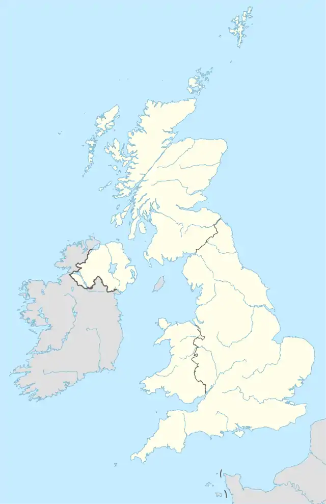
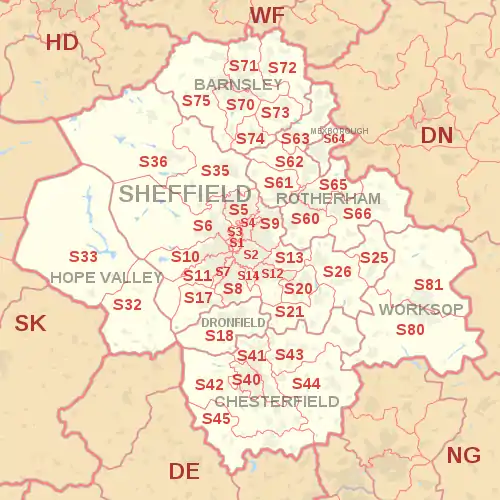
The S postcode area, also known as the Sheffield postcode area,[2] is a group of postcode districts in England, which are subdivisions of eight post towns. These cover most of South Yorkshire (post towns Sheffield, Barnsley, Rotherham and Mexborough), parts of north Derbyshire (post towns Chesterfield, Dronfield and the Hope Valley) and north-west Nottinghamshire (post town Worksop).

KML is from Wikidata
Sheffield
S
Coordinates: 53.397°N 1.407°W / 53.397; -1.407
CountryUnited Kingdom
Postcode area
S
Postcode area name
Sheffield
Post towns8
Postcode districts52
Postcode sectors248
Postcodes (live)33,439
Postcodes (total)49,099
Statistics as at May 2020[1]

History

For 1857–1868 an S sector of the London postal district existed.

Similarly, there were also S-prefixed postal districts in the compass-based system used in Glasgow: Glasgow S1, S2, S3 and S4 areas changed to postcodes G41 to G44.

  • S20 district was S19
  • S21, S25 and S26 were S31
  • S32 to S36 were S30.

S64, Mexborough post town, was earmarked for use as DN13 which has never been used, see DN postcode area.

Coverage

The approximate coverage of the postcode districts:

Postcode district Post town Coverage Local authority area(s)
S1 SHEFFIELD Sheffield City Centre, Devonshire Sheffield
S2 SHEFFIELD Arbourthorne, Heeley, Highfield, Manor, Norfolk Park, Wybourn, Park Hill, Castleback, Deep Pit, Cutler's View, Woodthorpe, Lowfield, Heeley Green, Newfield Green, Parkway Sheffield
S3 SHEFFIELD Broomhall, Burngreave, Neepsend, Netherthorpe, Kelham Island, West Bar, Parkwood Springs, Wicker, Millsands, West Bar Sheffield
S4 SHEFFIELD Grimesthorpe, Pitsmoor, Crab Tree, Brightside Sheffield
S5 SHEFFIELD Firth Park, Fir Vale, Longley, Shirecliffe, Shiregreen, Southey Green, Parson Cross, Wincobank, Norwood, Lane Top, Pismire hill Sheffield
S6 SHEFFIELD Bradfield, Dungworth, Hillsborough, Holdworth, Hollow Meadows, Loxley, Malin Bridge, Middlewood, Stannington, Storrs, Upperthorpe, Walkley, Wadsley Bridge, Wisewood, Wadsley, Fox Hill, Sheffield
S7 SHEFFIELD Abbeydale, Carter Knowle, Nether Edge, Millhouses, Beauchief Sheffield
S8 SHEFFIELD Batemoor, Beauchief, Greenhill, Jordanthorpe, Lowedges, Meersbrook, Norton, Norton Lees, Woodseats, Meadowhead Sheffield
S9 SHEFFIELD Attercliffe, Brightside, Darnall, Meadowhall, Tinsley, Wincobank, Tinsley, Newhall, Greenland, Handsworth Hill, Lower Don Valley Sheffield
S10 SHEFFIELD Broomhill, Broomhall, Crookes, Crookesmoor, Crosspool, Fulwood, Ranmoor, Endcliffe, Hallam Head, Steel Bank Sheffield
S11 SHEFFIELD Ecclesall, Endcliffe Park, Ecclesall Road, Greystones, Hunter's Bar, Millhouses, Sharrow Vale, Nether Edge, Whirlow, Brincliffe, Bents Green, Ringinglow, Whirlow, Fox House, ParkHead, Sharrow Sheffield
S12 SHEFFIELD Birley, Gleadless, Gleadless Townend, Frecheville, Hackenthorpe, Intake, Ridgeway, Hollins End, Highlane North East Derbyshire, Sheffield
S13 SHEFFIELD Fence, Handsworth, Richmond, Woodhouse, Woodhouse Mill, Normanton Spring, Woodthorpe Rotherham, Sheffield
S14 SHEFFIELD Gleadless Valley Sheffield
S17 SHEFFIELD Dore, Totley, Bradway, Totley Brook, Totley Rise Sheffield
S18 DRONFIELD Coal Aston, Dronfield, Dronfield Woodhouse, Holmesfield, Unstone North East Derbyshire
S20 SHEFFIELD Beighton, Crystal Peaks, Halfway, Mosborough, Owlthorpe, Sothall, Waterthorpe, Westfield, Plumbley, Holbrook Sheffield
S21 SHEFFIELD Eckington, Killamarsh, Renishaw, Spinkhill, Marsh Lane, Troway, Middle Handley, West Handley North East Derbyshire
S25 SHEFFIELD Anston, Brookhouse, Dinnington, Laughton-en-le-Morthen, Slade Hooton Rotherham
S26 SHEFFIELD Aston, Aughton, Harthill, Kiveton Park, Swallownest, Todwick, Wales, Waleswood, Woodall, Ulley Rotherham
S32 HOPE VALLEY Calver, Eyam, Grindleford, Hathersage, Stoney Middleton, Abney, Leam, Bretton, Foolow, Curbar, Upper Padley, North Padley, Derbyshire Dales
S33 HOPE VALLEY Bamford, Bradwell, Castleton, Edale, Hope, Yorkshire Bridge, Barber Booth, Aston , Thornhill High Peak
S35 SHEFFIELD Chapeltown, Crane Moor, Ecclesfield, Grenoside, High Green, Oughtibridge, Thurgoland, Wharncliffe Side, Wortley, Green Moor, Hermit Hill, Thurgoland, Worrall, Wharncliffe Side Sheffield
S36 SHEFFIELD Penistone, Thurlstone, Millhouse Green, Oxspring, Stocksbridge, Deepcar, Bolsterstone, Catshaw, Snowden hill, Langsett, Crow Edge, Carlecotes, Dunford Bridge, Midhopestones, Wigtwizzle, Ingbirchworth, Hoylandswaine, Upper Midhope Barnsley, Sheffield
S40 CHESTERFIELD Central and West Chesterfield, Brampton, Birdholme, Boythorpe Chesterfield
S41 CHESTERFIELD Hasland, North Chesterfield, Old Whittington, Sheepbridge, Whittington Moor, Tapton, Newbold, Hasland Green, Spital, Winsick, Hasland, Corbriggs Chesterfield, North East Derbyshire
S42 CHESTERFIELD Holymoorside, Grassmoor, North Wingfield, Tupton, Wingerworth, Mastin Moor, Overgreen, Cutthorpe, Eastmoor, Wadshelf, Walton, Grassmoor, Holmewood, North Wingfield, Temple Normanton, Alton Chesterfield, North East Derbyshire
S43 CHESTERFIELD Brimington, Barlborough, Clowne, Inkersall Green, Staveley, Barrow Hill, Hollingwood, Poolsbrook, Staveley, Mastin Moor Bolsover, Chesterfield
S44 CHESTERFIELD Bolsover, Calow, Sutton cum Duckmanton, Scarcliffe, Shuttlewood, Stanfree, Oxcroft, Arkwright Town, Sutton Scarsdale, Heath, Doe Lea, Stansby, Rowthorne, Ault Hucknall Bolsover, North East Derbyshire
S45 CHESTERFIELD Ashover, Clay Cross, Pilsley, Uppertown, Kelstedge, Farhill, Milltown, Littlemoor, Lower Pilsley, Hardstoft, Astwith, Hardstoft, Slack North East Derbyshire
S49 CHESTERFIELD Bulk users non-geographic
S60 ROTHERHAM Brinsworth, Catcliffe, Canklow, Clifton Central Rotherham, Masbrough, Moorgate, Treeton, Whiston Rotherham
S61 ROTHERHAM Greasbrough, Kimberworth, Rockingham, Thorpe Hesley, Munsborough, Scholes, Ferham Rotherham
S62 ROTHERHAM Rawmarsh, Wentworth, Parkgate, Abdy, Nether Haugh Rotherham
S63 ROTHERHAM Bolton-on-Dearne, Goldthorpe, Thurnscoe, Brampton, Wath-on-Dearne, West Melton Barnsley, Rotherham
S64 MEXBOROUGH Mexborough, Swinton, Kilnhurst, Adwick Upon Dearne Doncaster, Rotherham
S65 ROTHERHAM Herringthorpe, Hooton Roberts, Ravenfield, Thrybergh, East Dene, East Wood, Dalton
S66 ROTHERHAM Bramley Hellaby, Brampton-en-le-Morthen, Maltby, Stone, Thurcroft, Wickersley, Braithwell, Morthen, Stainton, Micklebring Rotherham
S70 BARNSLEY Central Barnsley, Birdwell, Stairfoot, Worsborough, Kendray Barnsley
S71 BARNSLEY Ardsley, Athersley, Monk Bretton, Lundwood, Royston Barnsley
S72 BARNSLEY Brierley, Cudworth, Grimethorpe, Shafton, South Hiendley Barnsley, City of Wakefield
S73 BARNSLEY Darfield, Wombwell, Hemingfield Barnsley, Rotherham
S74 BARNSLEY Elsecar, Hoyland, Jump, Blacker Hill Barnsley
S75 BARNSLEY Barugh Green, Cawthorne, Darton, Dodworth, Gawber, Mapplewell, Pogmoor, Staincross, Wilthorpe, Tankersley, Kexborough Barnsley
S80 WORKSOP Creswell, Thorpe Salvin, South Worksop, Whitwell Bassetlaw, Bolsover, Rotherham
S81 WORKSOP Blyth, Carlton-in-Lindrick, Langold, North Worksop, Shireoaks, Woodsetts Bassetlaw, Rotherham
S94 SHEFFIELD Census 2021 (a main national office) non-geographic
S95 SHEFFIELD Bulk users non-geographic
S96 SHEFFIELD Bulk users non-geographic
S97 ROTHERHAM, SHEFFIELD Bulk users non-geographic
S98 SHEFFIELD Bulk users non-geographic
S99 SHEFFIELD Jobcentre Plus non-geographic

Map

KML is from Wikidata
S postcode area map, showing postcode districts in red and post towns in grey text, with links to nearby DE, DN, HD, NG, SK and WF postcode areas.

See also

References

  1. "ONS Postcode Directory Version Notes" (ZIP). National Statistics Postcode Products. Office for National Statistics. May 2020. Table 2. Retrieved 19 June 2020. Coordinates from mean of unit postcode points, "Code-Point Open". OS OpenData. Ordnance Survey. February 2012. Retrieved 21 April 2012.
  2. Royal Mail, Address Management Guide, (2004)
This article is issued from Wikipedia. The text is licensed under Creative Commons - Attribution - Sharealike. Additional terms may apply for the media files.