Kotamobagu
Kotamobagu is a city in North Sulawesi, Indonesia. It covers an area of 108.89 km2, and had a population of 107,459 at the 2010 Census;[2] the latest official estimate (as at mid 2019) is 123,653.[3]
Kotamobagu | |
|---|---|
 Coat of arms | |
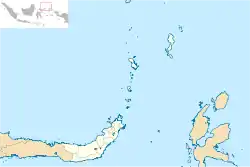 Location within North Sulawesi | |
| Coordinates: 0°44′N 124°19′E | |
| Country | |
| Province | |
| Government | |
| • Mayor | Tatong Bara |
| • Vice Mayor | Erlan Genggulang |
| Area | |
| • Total | 108.89 km2 (42.04 sq mi) |
| Population (mid 2019) | |
| • Total | 123,653 |
| • Density | 1,100/km2 (2,900/sq mi) |
| [1] | |
| Time zone | UTC+8 (Indonesia Central Time) |
| Area code | (+62) 434 |
| Website | kotamobagukota |

Administrative districts
The city is divided into four districts (kecamatan) tabulated below with their areas and their population as at the 2010 Census,[4] together with the official estimates for mid 2019.[5] The table also includes the number of administrative villages (urban kelurahan) in each district, and its postal codes.
| Name | Area in km2 | Population Census 2010 | Population Estimate mid 2019 | Number of villages | Post codes |
|---|---|---|---|---|---|
| Kotamobagu Selatan (South Kotamobagu) | 62.97 | 28,030 | 32,674 | 9 | 95717 |
| Kotamobagu Utara (North Kotamobagu) | 10.04 | 26,355 | 30,607 | 8 | 95713-95714 |
| Kotamobagu Timur (East Kotamobagu) | 23.69 | 37,698 | 42,656 | 10 | 95712-95719 |
| Kotamobagu Barat (West Kotamobagu) | 12.20 | 15,396 | 17,792 | 6 | 95711-95716 |
| Totals | 108.89 | 107,459 | 123,653 | 33 |
Autonomy
As an autonomous area, in 2011 Kotamobagu was judged the best autonomous area from among 57 autonomous areas which have been formed by central government since 2007.[6]
Climate
Kotamobagu has a tropical rainforest climate (Af) with moderate rainfall in August and September and heavy rainfall in the remaining months.
| Climate data for Kotamobagu | |||||||||||||
|---|---|---|---|---|---|---|---|---|---|---|---|---|---|
| Month | Jan | Feb | Mar | Apr | May | Jun | Jul | Aug | Sep | Oct | Nov | Dec | Year |
| Average high °C (°F) | 28.8 (83.8) |
28.8 (83.8) |
29.1 (84.4) |
29.8 (85.6) |
29.7 (85.5) |
29.6 (85.3) |
29.4 (84.9) |
30.0 (86.0) |
30.4 (86.7) |
30.5 (86.9) |
30.1 (86.2) |
29.3 (84.7) |
29.6 (85.3) |
| Daily mean °C (°F) | 25.0 (77.0) |
24.9 (76.8) |
25.2 (77.4) |
25.6 (78.1) |
25.7 (78.3) |
25.6 (78.1) |
25.3 (77.5) |
25.5 (77.9) |
25.5 (77.9) |
25.6 (78.1) |
25.7 (78.3) |
25.3 (77.5) |
25.4 (77.7) |
| Average low °C (°F) | 21.2 (70.2) |
21.1 (70.0) |
21.4 (70.5) |
21.4 (70.5) |
21.8 (71.2) |
21.6 (70.9) |
21.3 (70.3) |
21.1 (70.0) |
20.7 (69.3) |
20.8 (69.4) |
21.4 (70.5) |
21.4 (70.5) |
21.3 (70.3) |
| Average rainfall mm (inches) | 216 (8.5) |
179 (7.0) |
186 (7.3) |
201 (7.9) |
211 (8.3) |
174 (6.9) |
134 (5.3) |
93 (3.7) |
94 (3.7) |
136 (5.4) |
204 (8.0) |
197 (7.8) |
2,025 (79.8) |
| Source: Climate-Data.org[7] | |||||||||||||
References
- Badan Pusat Statistik, Jakarta, 2019.
- (in Indonesian) Jumlah Penduduk Sulawesi Utara Tahun 2010 Archived 2011-11-28 at the Wayback Machine
- Badan Pusat Statistik, Jakarta, 2020.
- Biro Pusat Statistik, Jakarta, 2011.
- Badan Pusat Statistik, Jakarta, 2019.
- "Kotamobagu Daerah Otonom Terbaik". March 22, 2012.
- "Climate: Kotamobagu". Climate-Data.org. Retrieved 22 November 2020.