Sangihe Islands Regency
The Sangihe Islands Regency (Indonesian: Kabupaten Kepulauan Sangihe) is a regency of North Sulawesi Province, Indonesia. It comprises a group of islands situated to the North of Sulawesi. It covers a land area of 461.11 km2, and had a population of 130,493 in the 2017 Estimates;[2] the latest estimation (as of 1 July 2019) was 131,800.[3] The principal island is also named Sangihe, on which lies the main town of Tahuna. Minor islands include the Marore group considerably to the North of Sangihe Island, the Tatoareng group to the South, and Nusa Tabukan off the Northeast coast.
Sangihe Islands Regency
Kabupaten Kepulauan Sangihe | |
|---|---|
 Seal | |
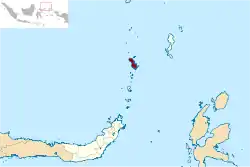 Location within North Sulawesi | |
| Coordinates: 03°00′N 125°30′E | |
| Country | |
| Province | |
| Capital | Tahuna |
| Government | |
| • Regent | Jabes Ezar Gaghana |
| • Vice Regent | Helmud Hontong |
| Area | |
| • Total | 736.98 km2 (284.55 sq mi) |
| Population (mid 2019)[1] | |
| • Total | 131,800 |
| • Density | 180/km2 (460/sq mi) |
| Time zone | UTC+8 (Indonesia Central Time) |
| Area code | (+62) 432 |
| Website | sangihekab.go.id |

Administration
The Regency is divided into fifteen districts (kecamatan), tabulated below with their 2017 estimated populations.[4]
| Name | English Name | Area in km2 | Population Census 2017 |
|---|---|---|---|
| Manganitu | 66.46 | 14,569 | |
| Tamako | 69.42 | 12,578 | |
| Manganitu Selatan | (South Manganitu) | 73.99 | 9,327 |
| Tatoareng | (Tatoareng Islands) | 18.56 | 3,982 |
| Tabukan Selatan | (South Tabukan) | 68.76 | 5,963 |
| Tabukan Selatan Tengah | (South Central Tabukan) | 46.84 | 2,754 |
| Tabukan Selatan Tenggara | (South Southeast Tabukan) | 22.29 | 2,147 |
| Tabukan Tengah | (Central Tabukan) | 87.39 | 9,996 |
| Tahuna | 25.76 | 18,899 | |
| Tahuna Timur | (East Tahuna) | 25.15 | 13,893 |
| Tahuna Barat | (West Tahuna) | 40.66 | 6,077 |
| Tabukan Utara | (North Tabukan) | 114.76 | 19,704 |
| Nusa Tabukan | 14.73 | 2,897 | |
| Kepulauan Marore | (Marore Islands) | 11.02 | 1,472 |
| Kendahe | 51.19 | 6,235 | |
| Totals | 736.98 | 130,493 |
Underwater volcano
300 metres southeast of Mahangetang Island, there is the Mahangetang underwater volcano with bubbles and hot water surrounding the peak which only 4 metres below the water at low tide and 8 metres at high tide.[5]
References
- Badan Pusat Statistik, Jakarta, 2019
- Biro Pusat Statistik, Jakarta, 2011.
- Badan Pusat Statistik, Jakarta, 2019
- Biro Pusat Statistik, Jakarta, 2017.
- "Kepulauan Sangihe". September 2, 2012.
| Wikimedia Commons has media related to Sangihe Islands. |