Kuntur Nasa (Potosí)
Kuntur Nasa (Aymara kunturi condor,[1]nasa nose,[2] "nose of a condor", Hispanicized spelling Condor Nasa) is a mountain in the Andes in Bolivia, about 3.800 m (12,467 ft) high. It is located in the Cordillera de los Frailes in the Potosí Department, Tomás Frías Province, Yocalla Municipality,[3] Kuntur Nasa lies south west of the higher Pari Chata at the river Pillku Mayu ("red river").
| Kuntur Nasa | |
|---|---|
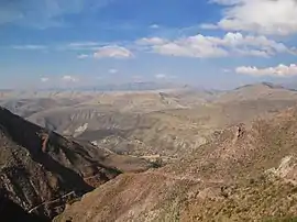 Cordillera de los Frailes, looking west. Pari Chata is on the right in the background, left of it is the Pillku Mayu valley. Kuntur Nasa is partly visible behind Pari Chata (darker mountain on the left) | |
| Highest point | |
| Elevation | 3,800 m (12,500 ft) |
| Coordinates | 19°20′S 66°3′W |
| Geography | |
 Kuntur Nasa Bolivia | |
| Location | Bolivia, Potosí Department, Tomás Frías Province |
| Parent range | Andes |
References
- Yatiqirinaka Aru Pirwa, Lima, 2005 (Aymara-Spanish dictionary): Kunturi - Cóndor
- www.katari.org Aymara-Spanish dictionary: Nasa (s.) - Nariz
- Yocalla Municipality: Archived 2016-05-08 at the Wayback Machine population data and map showing Kuntur Nasa
Capital: Potosí | ||
| Provinces |  | |
| Municipalities (and seats) |
| |
This article is issued from Wikipedia. The text is licensed under Creative Commons - Attribution - Sharealike. Additional terms may apply for the media files.