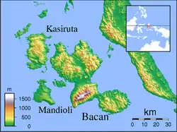
Labuha
Labuha is a small port town on the eastern Indonesian island of Pulau Bacan. It is the capital of the South Halmahera Regency, part of the province of North Maluku. It has a population at the 2010 Census of 10,272 (including the adjoining urban communes of Amasing Kota and Amasing Kota Barat).[1] The town is served by Labuha Airport.
Labuha | |
|---|---|
Town | |
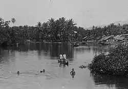 Children swimming in the vicinity of Labuha in the 1930s | |
| Coordinates: 0°37′40″S 127°28′50″E | |
| Country | Indonesia |
| Region | Maluku |
| Province | North Maluku |
| Regency | South Halmahera Regency |
| Time zone | UTC+9 (IEST) |
| Postcode | 97791 |
| Area code | (+62) 929 |

Climate
Labuha has a tropical rainforest climate (Af) with moderate to heavy rainfall year-round.
| Climate data for Labuha | |||||||||||||
|---|---|---|---|---|---|---|---|---|---|---|---|---|---|
| Month | Jan | Feb | Mar | Apr | May | Jun | Jul | Aug | Sep | Oct | Nov | Dec | Year |
| Average high °C (°F) | 30.0 (86.0) |
30.1 (86.2) |
30.1 (86.2) |
30.5 (86.9) |
30.1 (86.2) |
29.8 (85.6) |
29.2 (84.6) |
29.7 (85.5) |
30.0 (86.0) |
30.3 (86.5) |
31.1 (88.0) |
30.1 (86.2) |
30.1 (86.2) |
| Daily mean °C (°F) | 26.5 (79.7) |
26.6 (79.9) |
26.6 (79.9) |
26.9 (80.4) |
26.8 (80.2) |
26.6 (79.9) |
26.1 (79.0) |
26.4 (79.5) |
26.3 (79.3) |
26.5 (79.7) |
27.3 (81.1) |
26.6 (79.9) |
26.6 (79.9) |
| Average low °C (°F) | 23.1 (73.6) |
23.2 (73.8) |
23.2 (73.8) |
23.4 (74.1) |
23.5 (74.3) |
23.5 (74.3) |
23.1 (73.6) |
23.1 (73.6) |
22.7 (72.9) |
22.7 (72.9) |
23.6 (74.5) |
23.1 (73.6) |
23.2 (73.8) |
| Average rainfall mm (inches) | 187 (7.4) |
175 (6.9) |
193 (7.6) |
164 (6.5) |
154 (6.1) |
148 (5.8) |
165 (6.5) |
134 (5.3) |
105 (4.1) |
103 (4.1) |
133 (5.2) |
180 (7.1) |
1,841 (72.6) |
| Source: Climate-Data.org[2] | |||||||||||||
References
- Biro Pusat Statistik, Jakarta, 2011.
- "Climate: Labuha". Climate-Data.org. Retrieved August 9, 2020.
Regencies and cities of North Maluku | ||
|---|---|---|
Capital: Sofifi | ||
| Regencies | ||
| Cities | ||
This article is issued from Wikipedia. The text is licensed under Creative Commons - Attribution - Sharealike. Additional terms may apply for the media files.
