Laguna Caldera
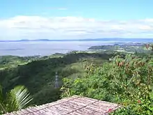
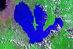
Laguna Caldera is a potentially active volcano and a geographical depression in Rizal, Philippines. It is broadly elliptical in shape, with dimensions of 20 by 10 km. It has a summit elevation of 743 m or 2,438 feet.[1] The caldera forms the middle lobe of Laguna de Bay, bound by the Morong Peninsula and Talim Island to the west, and the Jalajala Peninsula to the east.
| Laguna Caldera | |
|---|---|
.svg.png.webp) Laguna Caldera Location of Laguna Caldera in the Philippines | |
| Highest point | |
| Elevation | 743 m (2,438 ft) |
| Coordinates | 14°27′30″N 121°20′46″E |
| Geography | |
| Location | Rizal, Philippines |
| Geology | |
| Volcanic arc/belt | Macolod Corridor |

Laguna Caldera
Caldera activity started 1 million years ago, with the youngest eruption dated to 27,000-29,000 years ago. Deposits from the caldera form thick ignimbrite sheets in Rizal, Metro Manila, Laguna, and Bulacan.[2] Remnants of volcanic activity include undated maars at the southern end of Talim Island and a solfatara field on nearby Mount Sembrano.[1]
Photographs
 Laguna Caldera looking east
 Laguna Caldera looking south-east
 Laguna Caldera looking south
 Laguna Caldera looking west
 Laguna Caldera looking northwest
See also
References
- "Global Volcanism Program | Laguna Caldera". volcano.si.edu. Retrieved 2019-08-27.
- Catane, S. G. (2005). Explosive volcanism in the Philippines. Sendai-shi: Tōhoku Daigaku Tōhoku Ajia Kenkyū Sentā. ISBN 4901449257. OCLC 61505021.
This article is issued from Wikipedia. The text is licensed under Creative Commons - Attribution - Sharealike. Additional terms may apply for the media files.
