Laurelhurst, Portland, Oregon
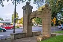
Laurelhurst is a neighborhood of vintage homes and undulating streets surrounding a park of the same name, straddling the NE and SE sections of Portland. Stone markers flank the entrances to the area. The center of the neighborhood, Coe Circle, contains a gilded equestrian statue of Joan of Arc, which is a World War I war memorial. The Laurelhurst Historic District was officially listed in the National Register of Historic Places In 2019.
Laurelhurst | |
|---|---|
Neighborhood | |
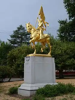 The equestrian statue of Joan of Arc in Coe Circle, Laurelhurst | |
 Laurelhurst | |
| Coordinates: 45°31′38″N 122°37′23″WPDF map | |
| Country | United States |
| State | Oregon |
| City | Portland |
| Government | |
| • Association | Laurelhurst Neighborhood Association |
| • Coalition | Southeast Uplift Neighborhood Program |
| Area | |
| • Total | 0.67 sq mi (1.73 km2) |
| Population (2000)[1] | |
| • Total | 4,549 |
| • Density | 6,800/sq mi (2,600/km2) |
| Housing | |
| • No. of households | 1765 |
| • Occupancy rate | 97% occupied |
| • Owner-occupied | 1615 households (92%) |
| • Renting | 150 households (8%) |
| • Avg. household size | 2.58 persons |
History
In 1909, the Ladd Estate Company sold its 462-acre (1.87 km2) Hazelfern Farm to the Laurelhurst Company for approximately $2 million. The name Laurelhurst was borrowed from a residential development in Seattle that Laurelhurst Company general manager Paul Murphy had recently completed. The name combined a reference to the laurel shrubbery near the Seattle development with the Old English hurst, denoting a wooded hill.[2] The Laurelhurst Company platted a residential development of 144 acres (0.58 km2) with the help of co-investor and landscape architect John Charles Olmsted. As the first houses were being built, the city purchased 31 acres (130,000 m2) for $92,000 to construct Laurelhurst Park. Advertised as a "High Class Residence Park," the Laurelhurst Company placed numerous restrictions on the neighborhood. Similar to the Ladd's Addition development, the sale of alcohol was prohibited. Additionally, there were to be no apartments, hotels, motels, flats, stables, or commercial buildings, and no homes were to be sold to Chinese, Japanese, or African Americans.[3]
The Laurelhurst Neighborhood Association (LNA) met as massive changes to Portland's transportation options were discussed in the 1970s, which led to the creation of TriMet MAX light rail in the 1980s. LNA and the community endorsed light rail being placed in the Banfield corridor, but was strongly opposed to alignment along the Burnside corridor, either a busway or light rail. 34 neighbors submitted a petition in 1978 objecting "to any parking, widening, or lane changes on East Burnside Street in the Laurelhurst area now or in the future', calling it "a serious threat" to the neighborhood, that it would lower property values, and be "a definite threat to our daily living pattern and destroy our neighborhood." The Portland-wide study noted a requirement to minimize projects "specifically in the Laurelhurst area".[4]
Redlining and racial covenant
In 1910, a racial covenant governing development of Laurelhurst mandated "...nor shall the same or any part thereof be in any manner used or occupied by Chinese, Japanese or negroes, except that persons of said races may be employed as servants by residents."[5]
A 1934 redlining map of Portland assigned the areas within current Laurelhurst boundaries with a blue grade, or "Still Desirable." Regarding the B19 tract, mapmakers noted "homogenous surroundings, improvements, and population" as among the neighborhood's favorable influences and called the subdivision's origins "a well conceived promotion, honestly administered"; regarding inhabitants, no foreign-born or Black inhabitants were reported.[6]
NIMBYism
The official neighborhood representative Laurelhurst Neighborhood Association sought to have homeless camps within 1,000 feet of schools, parks and where children congregate and further proposing that those who camp in this area should be fined up to $100 or sent to jail for up to 30 days.[7] Its members also vocally opposed the development in the neighborhood to increase housing availability.[8][9]
See also
References
- Demographics (2000)
- Snyder, Eugene E. (1979). Portland Names and Neighborhoods. Portland: Binford and Mort. p. 45. ISBN 978-0832303470.
- MacColl, E. Kimbark (1979). The Growth of a City: Power and Politics in Portland, Oregon 1915-1950. Portland, Oregon: The Georgian Press. ISBN 0-9603408-1-5.
- "Banfield Transitway Project, Multnomah County: Hearing and Project Report". TriMet/ODOT. 1978. pp. A-11, 72, 133. Retrieved 28 June 2020.
- "Portland Racial Covenants". Google My Maps. Retrieved 2020-07-04.
- "Mapping Inequality". dsl.richmond.edu. Retrieved 2020-07-04.
- Harbarger, Molly (2017-07-14). "Laurelhurst neighborhood asks city to ban homeless camping near parks, schools". oregonlive. Retrieved 2020-12-11.
- Jaywork, Casey (2018-01-29). "Three cities, one housing crisis | Cascadia Magazine". Retrieved 2020-12-11.
- Monahan, Rachel (June 21, 2017). "Portland's Laurelhurst Neighborhood Fights to Keep the Housing Crisis Out". Willamette Week. Retrieved 2020-12-11.
External links
 Media related to Laurelhurst, Portland, Oregon at Wikimedia Commons
- Portland Parks & Recreation: Laurelhurst Park
- Laurelhurst Street Tree Inventory Report