List of Historic Sites of Japan (Saga)
National Historic Sites
As of 1 August 2019, twenty-five Sites have been designated as being of national significance (including three *Special Historic Sites); Kii Castle spans the prefectural borders with Fukuoka.[2][3][4]
| Site | Municipality | Comments | Image | Coordinates | Type | Ref. |
|---|---|---|---|---|---|---|
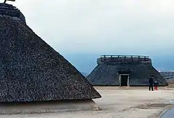
| *Yoshinogari Site 吉野ヶ里遺跡 Yoshinogari iseki | Kanzaki, Yoshinogari | fortified Yayoi-period settlement, the subject of extensive excavation from 1986; 2500 burials with ICP grave goods have been uncovered; the site has been reconstructed on the basis of hypotheses drawn from the postholes; now a National Government Park[5][6] | 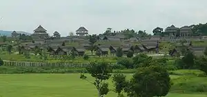 | 33°19′31″N 130°23′04″E | 1 | |
| *Nagoya Castle Site 名護屋城跡並陣跡 Nagoya-jō ato narabainijin ato | Karatsu, Genkai | begun in 1591 and completed five months later; extends over 17 ha; stone walls, earthworks, moats, gates and other buildings have been identified; served as the base for Hideyoshi's invasions of Korea between 1592 and 1598;[5] focus of the Saga Prefectural Nagoya Castle Museum | 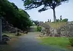 | 33°31′49″N 129°52′05″E | 2 | |
| *Kii Castle Site 基肄(椽)城跡 Kii-jō ato | Kiyama | its construction in 665 under Baekje guidance, as the castle of Woyogi (椽), is chronicled in Nihon Shoki; formed part of a network of defences dating to the immediate aftermath of the Battle of Hakusukinoe in 663 to protect Dazaifu against the threat of invasion from the Korean peninsula by Silla-Tang forces;[7][8][9] the designation includes an area of Chikushino in Fukuoka Prefecture | 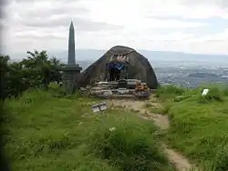 | 33°26′36″N 130°30′45″E | 2 | |
| Otsuboyama Kōgoishi おつぼ山神籠石 Otsuboyama kōgoishi | Takeo | earthworks stretching 1,866 m, with stone pillar bases and sluice gates; there is a theory that construction was related to defeat at the Battle of Hakusukinoe in 663[10] | 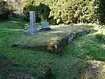 | 33°10′41″N 130°03′23″E | 1 | |
| Yasunagata Site 安永田遺跡 Yasunagata iseki | Tosu | Yayoi-period "high-tech factory" (ハイテク工場); bronze-casting site, discovered in 1974 and extending over an area of 4,400 m2, with five moulds for dōtaku (bells) and five for hoko (spears); traces of bronze found on the valley floor suggest this may have been the site of the smelting works[11] | 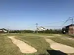 | 33°23′55″N 130°30′52″E | 1 | |
| Yokotashimo Kofun 横田下古墳 Yokotashimo kofun | Karatsu | kofun or burial mound with red walls and three stone sarcophagi in which were found, in 1923, bronze mirrors and cylinders, magatama (comma-shaped beads), iron arrowheads, armour, and Haji ware[12][13] | 33°26′04″N 130°02′01″E | 1 | ||
| Kakiemon Kiln Site 柿右衛門窯跡 Kakiemon kama ato | Arita | double climbing kiln: A, with 12 firing chambers, a length of 42 metres, and an average incline of 11.5°; and B, with 21 chambers, a length of 83 metres, and an average gradient of 13°; saggars and kiln tools have also been recovered[14] | 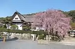 | 33°10′51″N 129°52′07″E | 6 | |
| Nabatake Site 菜畑遺跡 Nabatake iseki | Karatsu | acclaimed as Japan's first paddy; important for the understanding of the adoption of wet-rice technology, introduced from the continent;[5] focus of the Matsurokan exhibition hall | 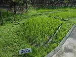 | 33°26′55″N 129°57′28″E | 1 | |
| Mietsu Naval Dock Site 三重津海軍所跡 Mietsu kaigunsho ato | Saga | inscribed on the UNESCO World Heritage List as one of the Sites of Japan’s Meiji Industrial Revolution: Iron and Steel, Shipbuilding and Coal Mining[15] | 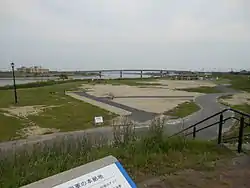 | 33°12′28″N 130°20′24″E | 2 | |
| Anegawa Castle Site 姉川城跡 Anegawa-jō ato | Kanzaki | strategic site under Ryūzōji Takanobu but declined in importance after the unification of Kyūshū by Toyotomi Hideyoshi; the site extends 600 metres E-W and 800 N-S, with related mansions, temples and shrines, and a complex network of moats[16] | 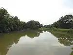 | 33°17′35″N 130°20′54″E | 2 | |
| Katsuno Castle Chiku Clan Site 勝尾城筑紫氏遺跡 Katsuno-jō Chikushi-shi iseki | Tosu | fortified at the end of the fifteenth century; attacked by the Shimazu clan in 1586 and later abandoned; excavations from 1995 have revealed an extensive site with moats, earthworks, mansions for retainers, temples and shrines[17] | 33°24′08″N 130°27′55″E | 2 | ||
| Nishikuma Kofun 西隈古墳 Nishikuma kofun | Saga | C5 decorated kofun housing a large sarcophagus, with red pigmentation and incised decoration of triangles and circles[5][18] | 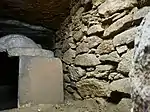 | 33°19′39″N 130°17′36″E | 1 | |
| Taku Seibyō 多久聖廟 Taku Seibyō | Taku | a Neo-Confucian school was established by Taku Shigefumi (多久茂文) in 1699; the ICP temple dates to 1708; major repairs at the end of the Shōwa period were completed in 1990[19][20] | 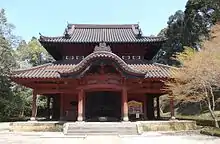 | 33°15′35″N 130°05′51″E | 4 | |
| Obukumayama Kōgoishi 帯隈山神籠石 Obukumayama kōgoishi | Saga | C7 fortifications discovered in 1941, that extend for 2.4 km and include a gate[13] |  | 33°20′01″N 130°20′04″E | 1 | |
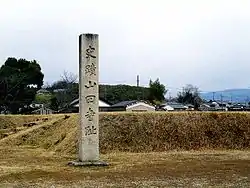
| Ōkuma Shigenobu Former Residence 大隈重信旧宅 Ōkuma Shigenobu kyū-taku | Saga | birthplace in 1838 of the Meiji statesman and future prime minister; dismantled for repairs in 1968 and open to the public alongside the Ōkuma Memorial Museum (大隈記念館)[13] | 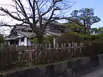 | 33°14′53″N 130°18′31″E | 8 | |
| Ōkawachi Nabeshima Kiln Site 大川内鍋島窯跡 Ōkawachi Nabeshima kama ato | Imari | the ceramic craft technique of Nabeshima iro (overglaze) is an Important Intangible Cultural Property[21][22] | 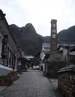 | 33°13′57″N 129°53′37″E | 6 | |
| Taniguchi Kofun 谷口古墳 Taniguchi kofun | Karatsu | seventy-seven metre, keyhole-shaped kofun with two stone chambers, boat-shaped sarcophagi, and grave goods that include mirrors, stone combs, items made of iron, and haji ware, dated to the end of the fourth century[5] | 33°27′10″N 130°03′16″E | 1 | ||
| Chōshizuka Kofun 銚子塚古墳 Chōshizuka kofun | Saga | large early kofun, 98 metres long and dating to the second half of the fourth century[5] | _zenkei.JPG.webp) | 33°19′04″N 130°17′58″E | 1 | |
| Tashiroōta Kofun 田代太田古墳 Tashiroōta kofun | Tosu | triple-chambered, 42 metre decorated kofun with red ochre, carbon black and green earth paintings of triangles, concentric circles, boats, humans with outstretched arms, and figures on horseback, concentrated on the rear wall of the burial chamber[23][24] |  | 33°23′42″N 130°30′55″E | 1 | |
| Habu Site 土生遺跡 Habu iseki | Ogi | Yayoi settlement discovered in 1971 during works to remedy environmental damage caused by mining; evidence uncovered of houses (some now reconstructed), storage pits, and wells, along with the first mould for a yari ganna (spear-plane), tools of stone and wood, and ceramics[5] | 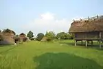 | 33°16′33″N 130°12′02″E | 1 | |
| Karatsu Matsuura Clan Graves 唐津松浦墳墓群 Karatsu Matsuura funbo-gun | Karatsu | designation includes the Hayamjiri Dolmen Cluster (葉山尻支石墓群) (Jōmon-period cemetery discovered in 1951 and excavated in 1952/3; six dolmens, twenty-six jar burials, and one kofun identified),[5] Ōdomo Site (大友遺跡), Moritashi Dolmen Cluster (森田支石墓群), and Sakura no Baba Site (桜馬場遺跡) | 33°24′37″N 130°01′18″E | 1 | ||
| Higashimyō Site 東名遺跡 Higashimyō iseki | Saga | 33°15′48″N 130°18′03″E | 1 | |||
| Hizen Provincial Headquarters Site 肥前国庁跡 Bizen koku-chō ato | Saga | ruins of the Nara- and early Heian-period administrative centre of Hizen Province, extending 105 metres N-S and 77 metres E-W, with similarities to Dazaifu[13] | 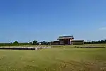 | 33°19′01″N 130°16′26″E | 2 | |
| Hizen Porcelain Kiln Sites 肥前磁器窯跡 Bizen-jiki kama ato | Arita, Takeo, Ureshino | designation includes the Tengudani Kiln Site (天狗谷窯跡), Yanbeta Kiln Site (山辺田窯跡), Haraake Kiln Site (原明窯跡), Hyakken Kiln Site (百間窯跡), Fudōyama Kiln Site (不動山窯跡), and the site of the Izumiyama Clayworks (泉山磁石場跡) | 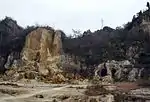 | 33°11′39″N 129°54′36″E | 6 | |
| Hizen Pottery Kiln Sites 肥前陶器窯跡 Bizen-tōki kama ato | Takeo, Karatsu, Taku | active from the late C16/early C17[13] | 33°14′08″N 129°59′07″E | 6 | ||
Prefectural Historic Sites
As of 1 August 2019, forty-seven Sites have been designated as being of prefectural importance.[4][25]
| Site | Municipality | Comments | Image | Coordinates | Type | Ref. |
|---|---|---|---|---|---|---|
| Funazuka 船塚 Funazuka | Saga | _enkei.JPG.webp) | 33°18′48″N 130°14′29″E | |||
| Isezuka 伊勢塚 Isezuka | Kanzaki | 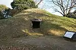 | 33°20′48″N 130°22′52″E | |||
| Udono Stone Buddhas 鵜殿石仏群 Udono sekibutsu-gun | Karatsu |  | 33°20′55″N 130°00′08″E | |||
| Daiganji Haiji Site 大願寺廃寺跡 Daiganji Haiji ato | Saga | 33°19′01″N 130°15′05″E | ||||
| Teraura Haiji Pagoda Site and Foundation Stones 寺浦廃寺塔跡ならびに礎石 Teraura Haiji tō ato narabini soseki | Ogi | 33°17′56″N 130°10′53″E | ||||
| Sekigyōmaru Kofun 関行丸古墳 Sekigyōmaru kofun | Saga | 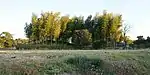 | 33°19′53″N 130°19′40″E | |||
| Shimadazuka 島田塚 Shimadazuka | Karatsu | 33°26′02″N 130°00′45″E | ||||
| Itō Genboku Former Residence 伊東玄朴旧宅 Itō Genboku kyūtaku | Kanzaki | 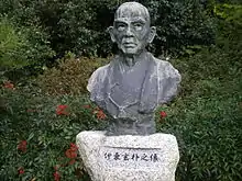 | 33°21′22″N 130°21′51″E | |||
| Himekata Site 姫方遺跡(雌塚、方形周溝墓、環状列石土壙墓) Himekata iseki (Mezuka, hōkeishū-kōbo, retsujō resseki dokōbo) | Miyaki | three burials are preserved, one with a stone circle | 33°21′07″N 130°26′44″E | |||
| Tsurugizuka 剣塚 Tsurugizuka | Tosu | 33°23′57″N 130°31′26″E | ||||
| Koshindōzuka 庚申堂塚 Koshindōzuka | Tosu |  | 33°23′45″N 130°30′47″E | |||
| Kojima Kofun 小島古墳 Kojima kofun | Imari | 33°19′21″N 129°48′50″E | ||||
| Himezuka 姫塚 Himezuka | Ogi | 33°18′33″N 130°13′53″E | ||||
| Ryūōzaki Kofun Cluster 龍王崎古墳群 Ryūōzaki kofun-gun | Shiroishi | 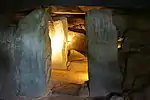 | 33°08′13″N 130°07′15″E | |||
| Onizuka 鬼塚 Onizuka | Kashima | 33°05′51″N 130°06′00″E | ||||
| Hoshirō Kiln Site 保四郎窯跡 Hoshirō kama ato | Taku | 33°15′42″N 130°05′21″E | ||||
| Shiomi Kofun 潮見古墳 Shiomi kofun | Takeo | 33°10′28″N 130°02′42″E | ||||
| Yanoura Kofun 矢ノ浦古墳 Yanoura kofun | Takeo | 33°11′28″N 130°01′53″E | ||||
| Tsutsue Kiln Site 筒江窯跡 Tsutsue kama ato | Takeo | 33°13′24″N 129°55′12″E | ||||
| Futatsukayama-Gohondani Site 二塚山五本谷遺跡 Futatsukayama-Gohondani iseki | Kamimine | 33°20′40″N 130°25′10″E | ||||
| Shirohebiyamaiwa Site 白蛇山岩陰遺跡 Shirohebiyamaiwa iseki | Imari | 33°16′18″N 129°50′12″E | ||||
| Funaishi Site 船石遺跡 Funaishi iseki | Kamimine | 33°20′32″N 130°25′35″E | ||||
| Kodaru No.2 Kiln Site 小樽2号窯跡 Kodaru nigō kama ato | Arita | 33°11′21″N 129°54′20″E | ||||
| Kayanotani No.1 Kiln Site 茅ノ谷1号窯跡 Kayanotani ichigō kama ato | Imari | 33°16′17″N 129°56′12″E | ||||
| Akasaka Kofun 赤坂古墳 Akasaka kofun | Tosu | 33°24′01″N 130°31′31″E | ||||
| Himekata Keyhole Mound 姫方前方後円墳 Himekata zenpōkōen-fun | Miyaki | 33°20′53″N 130°26′54″E | ||||
| Tamashima Kofun 玉島古墳 Tamashima kofun | Takeo | 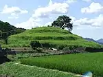 | 33°10′02″N 130°03′17″E | |||
| Tsutsumi Earthworks 堤土塁跡 Tsutsumi dorui ato | Kamimine |  | 33°20′50″N 130°25′24″E | |||
| Shishiga Castle Site 獅子城跡 Shishiga-jō ato | Karatsu | 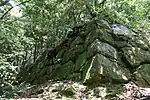 | 33°18′44″N 130°02′30″E | |||
| Chasenzuka Kofun 茶筅塚古墳 Chasenzuka kofun | Ogi | 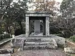 | 33°17′26″N 130°11′45″E | |||
| Takayanagi Ōtsuka 高柳大塚 Takayanagi ōtsuka | Miyaki | 33°21′28″N 130°25′50″E | ||||
| Gongenyama Keyhole Mound and No.2 Mound 権現山前方後円墳及び2号墳(円墳) Gongenyama zenpōkōen-fun oyobi nigō-fun (en-fun) | Ogi | 33°18′20″N 130°13′09″E | ||||
| Maruyama Kofun 円山古墳 Maruyama kofun | Ogi | 33°18′19″N 130°13′22″E | ||||
| Taijako Kofun 多蛇古古墳(1号墳) Taijako kofun (ichigō-fun) | Takeo | 33°12′19″N 130°01′43″E | ||||
| Tsumayama Kofun Cluster No.4 Mound 妻山古墳群4号墳 Tsumayama kofun-gun yongō-fun | Shiroishi | decorated kofun | 33°11′16″N 130°05′52″E | |||
| Yoshinogari Site 吉野ヶ里遺跡 Yoshinogari iseki | Kanzaki | area surrounding the Special Historic Site | 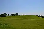 | 33°19′19″N 130°22′53″E | ||
| Kishitake Castle Site 岸岳城跡 Kishitake-jō ato | Karatsu | 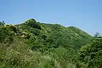 | {33°21′24″N 129°58′40″E | |||
| Kogumayama Kofun 小隈山古墳 Kogumayama kofun | Saga | 33°19′11″N 130°15′21″E | ||||
| Sayantani Kofun 道祖谷古墳 Sayantani kofun | Shiroishi | 33°10′45″N 130°04′42″E | ||||
| Takashi Jinja Site 高志神社遺跡 Takashi Jinja iseki | Kanzaki | 33°16′59″N 130°23′14″E | ||||
| Chirikudoi 千栗土居 Chirikudoi | Miyaki | 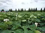 | 33°19′32″N 130°28′32″E | |||
| Saga Castle Site 佐賀城跡 Saga-jō ato | Saga | 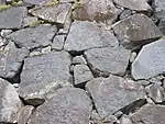 | 33°14′43″N 130°18′08″E | |||
| Hisagozuka Kofun 瓢塚古墳 Hisagozuka kofun | Karatsu | 33°33′49″N 129°53′06″E | ||||
| Kishidake Old Kiln Site 岸岳古窯跡 (道納屋窯跡) Kishidake koyō ato (Michinaya kama ato) | Karatsu | 33°21′28″N 129°58′13″E | ||||
| Nita Haniwa Kiln Site 仁田埴輪窯跡 Nita haniwa kama ato | Karatsu | 33°27′21″N 130°03′00″E | ||||
| Kurisōzui Kofun 久里双水古墳 Kurisōzui kofun | Karatsu | 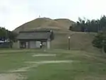 | 33°23′49″N 129°59′11″E | |||
Municipal Historic Sites
As of 1 May 2018, a further eighty-one Sites have been designated as being of municipal importance.[26]
See also
| Wikimedia Commons has media related to National historic sites in Saga prefecture. |
| Wikimedia Commons has media related to Prefectural Historic Sites in Saga Prefecture. |
References
- "Cultural Properties for Future Generations". Agency for Cultural Affairs. Retrieved 3 August 2019.
- 史跡名勝天然記念物 [Number of Monuments of Japan by Prefecture] (in Japanese). Agency for Cultural Affairs. 1 July 2019. Retrieved 5 August 2019.
- "Database of National Cultural Properties: 史跡名勝天然記念物 (史跡, 特別史跡 佐賀県 2県以上)" (in Japanese). Agency for Cultural Affairs. Archived from the original on 2 May 2017. Retrieved 5 August 2019.
- 佐賀県内所在指定文化財等件数一覧 [Number of Cultural Properties in Saga Prefecture] (in Japanese). Saga Prefecture. 1 August 2019. Retrieved 5 August 2019.
- 国指定 (史跡の部) 01 [National Historic Sites 1] (in Japanese). Saga Prefecture. Retrieved 11 June 2012.
- "Yoshinogari Historical Park". Yoshinogari Historical Park. Retrieved 11 June 2012.
- 基肄城 [Kii Castle] (in Japanese). Kiyama Town. Archived from the original on 25 September 2010. Retrieved 11 June 2012.
- 基肄城 [Kii Castle] (in Japanese). Chikushino City. Retrieved 11 June 2012.
- Aston, W.G. (1972) [1896]. Nihongi: Chronicles of Japan from the Earliest Times to A.D. 697. 2. Tuttle. pp. 283f. ISBN 0-8048-0984-4.
- おつぼ山神籠石 [Otsuboyama Kōgoishi] (in Japanese). Takeo City. Retrieved 11 June 2012.
- 安永田遺跡 [Yasunagata Site] (in Japanese). Tosu City. Retrieved 11 June 2012.
- 横田下古墳 [Yokotashimo Kofun] (in Japanese). Agency for Cultural Affairs. Archived from the original on 18 December 2012. Retrieved 11 June 2012.
- 国指定 (史跡の部) 02 [National Historic Sites 2] (in Japanese). Saga Prefecture. Retrieved 11 June 2012.
- 柿右衛門窯跡 [Kakiemon Kiln Site] (in Japanese). Agency for Cultural Affairs. Retrieved 11 June 2012.
- "Sites of Japan's Meiji Industrial Revolution: Iron and Steel, Shipbuilding and Coal Mining". UNESCO. Retrieved 5 August 2019.
- 国指定 (史跡の部) 01 [National Historic Sites 3] (in Japanese). Saga Prefecture. Retrieved 14 June 2012.
- "勝尾城筑紫氏遺跡" [Katsuno Castle Chiku Clan Site]. Agency for Cultural Affairs. Retrieved 16 June 2012.
- 西隈古墳 [Nishikuma Kofun] (in Japanese). Kyushu National Museum. Retrieved 9 December 2013.
- 多久聖廟 [Taku Seibyō] (in Japanese). Taku City. Retrieved 14 June 2012.
- 多久聖廟 [Taku Seibyō] (in Japanese). Agency for Cultural Affairs. Retrieved 14 June 2012.
- 色鍋島 [Nabeshima iro-e] (in Japanese). Agency for Cultural Affairs. Retrieved 14 June 2012.
- "iro-e". Japanese Architecture and Art Net Users System. Retrieved 14 June 2012.
- 田代太田古墳 [Tashiroōta Kofun] (in Japanese). Tosu City. Retrieved 16 June 2012.
- 田代太田古墳 [Tashiroōta Kofun] (in Japanese). Kyushu National Museum. Retrieved 9 December 2013.
- 都道府県別指定等文化財件数(都道府県分) [Number of Prefectural Cultural Properties by Prefecture] (in Japanese). Agency for Cultural Affairs. 1 May 2018. Retrieved 5 August 2019.
- "都道府県別指定等文化財件数(市町村分)" [Number of Municipal Cultural Properties by Prefecture] (in Japanese). Agency for Cultural Affairs. 1 May 2018. Retrieved 5 August 2019.
External links
- (in Japanese) Cultural Properties in Saga Prefecture
This article is issued from Wikipedia. The text is licensed under Creative Commons - Attribution - Sharealike. Additional terms may apply for the media files.