Interstate 40 in Tennessee
Interstate 40 (I-40) traverses the entirety of the state of Tennessee from west to east, running from the Mississippi River at the Arkansas border to the northern base of the Great Smoky Mountains at the North Carolina border. The road connects Tennessee's three largest cities—Memphis, Nashville, and Knoxville—and crosses all of Tennessee's physiographical provinces and Grand Divisions—the Mississippi Embayment and Gulf Coastal Plain in West Tennessee, the Highland Rim and Nashville Basin in Middle Tennessee, and the Cumberland Plateau, Appalachian Valley and Ridge Province, and Blue Ridge Province in East Tennessee. The Tennessee section of I-40 is 454.81 miles (731.95 km) long, the longest of any state on the route.
| ||||
|---|---|---|---|---|
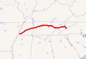
I-40 highlighted in red | ||||
| Route information | ||||
| Maintained by TDOT | ||||
| Length | 454.81 mi (731.95 km) | |||
| Existed | 1958–present | |||
| Major junctions | ||||
| West end | ||||
| East end | ||||
| Location | ||||
| Counties | Shelby, Fayette, Haywood, Madison, Henderson, Carroll, Decatur, Benton, Humphreys, Hickman, Dickson, Williamson, Cheatham, Davidson, Wilson, Smith, Putnam, Cumberland, Roane, Loudon, Knox, Sevier, Jefferson, Cocke | |||
| Highway system | ||||
| ||||

Route description
Memphis

I-40 enters Tennessee via the six lane Hernando de Soto Bridge, which spans the Mississippi River at river mile 736. Immediately within the city of Memphis, the interstate passes across the southern half of Mud Island before crossing the Wolf River Harbor into downtown Memphis. Throughout Memphis, the highway contains a minimum of six through lanes, except through major interchanges. Upon reaching Memphis, I-40 immediately has an interchange with U.S. Route 51 (US 51), and one mile (1.6 km) from the state line is an interchange with the western terminus of I-240, where I-40 abruptly turns north, following a route formerly designated as part of I-240. (For the next 10 miles [16 km], this segment is designated as the Dr. Martin Luther King Jr. Memorial Expressway.) About one mile later, I-40 has an interchange with State Route 14 (SR 14, Jackson Avenue), and about two miles (3.2 km) beyond this point, the highway crosses the Wolf River and has an interchange with the eastern terminus of SR 300, a controlled-access connector to US 51. At this interchange, the Interstate turns sharp east. Passing first near the neighborhoods of Frayser and Raleigh, about five miles (8.0 km) later, I-40 crosses the Wolf River for a second time as the highway turns southeast, and has an interchange with SR 14 again. Two miles later is an interchange with SR 204 (Covington Pike), and two miles (3.2 km) beyond this point, I-40 comes to a complicated interchange with US 64/US 70/US 79, I-240 southbound and Sam Cooper Boulevard eastbound, and turns sharp northeast, leaving Memphis, and crossing the Wolf River for a third and final time about 1⁄2 mile (0.80 km) later. For the next several miles the highway is known as the Isaac Hayes Memorial Highway and is eight lanes, the left lanes functioning as HOV lanes during rush hour. This segment passes through several major suburbs of Memphis, including Bartlett, Cordova, and Lakeland. At exit 18, which is US 64, the highway narrows to six lanes, and to four lanes a short distance beyond. Several miles later, near Arlington, at exit 24, is a cloverleaf interchange with I-269/SR 385.
Gulf coastal plain
.jpg.webp)
About one mile east of Arlington, I-40 enters Fayette County, and about another mile later crosses the Loosahatchie River and leaves the Memphis area, traversing through the Gulf Coastal Plain in a very flat and straight stretch of mostly farmland with some rural woodlands, bypassing most cities and communities. At exit 35 is an interchange with SR 59, which connects to Covington and Somerville. About 8 miles (13 km) later, I-40 enters Haywood County, and about 10 miles (16 km) later, the highway turns north and enters the Hatchie National Wildlife Refuge and crosses the Hatchie River. Upon exiting the refuge about 4 miles (6.4 km) later, I-40 turns east and passes just southeast of Brownsville, where it has an interchange first with SR 76, which also connects to Somerville. Eight miles later is an interchange with US 70, and 2 miles (3.2 km) later, I-40 enters Madison County. Entering Jackson, at mile marker 78, the interstate crosses the South Fork of the Forked Deer River. Passing through the northern half of the city, I-40 has a total of six exits in Jackson. First, at mile 79, is an interchange with US 412 (which connects to Alamo and Dyersburg), then about 1 mile (1.6 km) later an interchange with the US 45 Bypass. About 1.5 miles (2.4 km) later is an interchange with US 45, which also connects to Humboldt and Milan, and about 5 miles (8.0 km) later is an interchange with US 70, which also connects to Huntingdon, and I-40 leaves Jackson at this point. From this point, I-40 continues east northeast through a sparsely populated area of farmland and woodlands, and about 7 miles (11 km) later enters Henderson County. About 15 miles (24 km) later, near the community of Parkers Crossroads, I-40 has an interchange with SR 22, a major north-south connector route in west Tennessee, which, at this interchange, is signed as a connector to Lexington and Huntington. A few miles later, I-40 crosses the Big Sandy River before proceeding through the northern half of the Natchez Trace State Park, and around milepost 120 enters Decatur County. About 6 miles (9.7 km) later is an interchange with US 641/SR 69, another major north-south corridor, which at this point connects to Camden and Decaturville. I-40 then enters Benton County, and about 6 miles (9.7 km) later, descends about 400 feet (120 m) on a steep grade over the course of a mile, the westbound lanes gaining a truck climbing lane, before crossing the Tennessee River into Middle Tennessee on the 1⁄2 mile (0.80 km) Jimmy Mann Evans Memorial Bridge. This river crossing is also located within the Tennessee National Wildlife Refuge.
Western highland rim
Upon crossing the Tennessee River into Humphreys County, I-40 traverses through mostly vast woodlands in the rugged hills of the Western Highland Rim for a considerable distance. This section is characterized by several noticeable upgrades and downgrades, with mostly minor curves. About 8 miles (13 km) beyond the Tennessee River is an interchange with SR 13, which connects to Linden and Waverly. About 5 miles (8.0 km) later, I-40 crosses into Hickman County and has an interchange with SR 50, which connects to Centerville. I-40 then crosses the Duck River, traveling through mostly wooded areas characterized by further rugged terrain, and at mile 163 is an interchange with SR 48, the first exit for Dickson. I-40 then enters Dickson County, and shortly beyond this point crosses the Piney River. About 6 miles (9.7 km) is an interchange with SR 46, the second Dickson exit which also connects to Centerville and Columbia. Approaching the urban parts of the Nashville metropolitan area, 4 miles (6.4 km) later is the western terminus of Interstate 840, the outer southern beltway around Nashville. The highway continues through mostly woodlands and rugged terrain, and crossing into Williamson County, I-40 briefly enters a steep ascent, gaining a truck climbing lane on the eastbound side, and 6 miles (9.7 km) beyond I-840 has an interchange with SR 96, which connects to the Nashville suburbs of Fairview and Franklin. A few miles later, I-40 enters Cheatham County, and descends into the Nashville Basin between mile markers 186 and 188, and still in a predominantly rural area, has an interchange with SR 248 in Kingston Springs. I-40 then crosses the Harpeth River twice over a distance of about 1 mile (1.6 km).
Nashville
_in_Nashville.JPG.webp)
Around milepost 191, I-40 enters Davidson County, and a few miles later crosses the Harpeth River for a third time. About a mile later, near Bellevue, I-40 widens to six lanes, entering the urban outskirts of Nashville, and has an interchange with US 70S. Three miles later is an exit with SR 251 (Old Hickory Boulevard), and 2 miles (3.2 km) later is an interchange with US 70. Widening to eight lanes, three miles later is an interchange with SR 155 (Briley Pkwy, White Bridge Road), including the western terminus of the northern controlled-access beltway around Nashville. About two miles later is the western terminus of I-440, the southern loop around central Nashville. Two miles later, I-40 enters Downtown Nashville, and begins a brief concurrency with I-65, turning southeast. As part of the route around downtown Nashville known locally as the Downtown Loop, the two concurrent routes have interchanges with US 70 (Charlotte Avenue) and US 70S/431 (Broadway), as well as two surface streets, Church Street and Demonbreun Street. About two miles later the two concurrent routes turn east northeast, and I-65 splits off and heads south. Briefly on its own for about 1 mile (1.6 km), I-40 crosses a long viaduct, and has an interchange with US 31A/41A (4th Avenue, 2nd Avenue), before beginning a brief concurrency with I-24 and turning southeast. About 2 miles (3.2 km) later, I-24 splits off, and I-40 turns east. The eastern terminus of I-440 is also directly accessible from the east bound lanes of I-40 at this interchange, and US 41, which crosses I-24 before this interchange, is also directly accessible from I-40 at this interchange.

About 1.5 miles (2.4 km) later, I-40 has an interchange with SR 155 (Briley Parkway) near the Nashville International Airport, and about a mile later, the eastbound lanes have a direct access partial-y exit to a surface road to the airport. The westbound lanes of I-40 are only accessible from this interchange. Less than a half mile later is an exit with SR 255 (Donelson Pike), and beginning here, the left lanes of I-40 function as HOV lanes during rush hour. Passing near J. Percy Priest Dam, I-40 has an interchange with Stewarts Ferry Pike, then crosses the Stones River, and has an interchange with SR 45 (Old Hickory Boulevard). Also at this interchange is a separate partial interchange which provides access to SR 45 via a bypass which junctions with SR 45 about 3⁄4 mile (1.2 km) north of I-40. This bypass is only accessible via the eastbound lanes of I-40, and the westbound lanes are only accessible from it. About 3 miles (4.8 km) later, I-40 enters Wilson County, and few miles later has an interchange with SR 171 near the Nashville suburb of Mount Juliet. Six miles later is an interchange with SR 109, which connects to Gallatin. About 3 miles (4.8 km) later and about 25 miles (40 km) east of Nashville, the route narrows back to four lanes and has an interchange with the eastern terminus of I-840 a few miles east of Lebanon. I-40 the enters Lebanon and has interchanges with US 231 and US 70.
Eastern Highland Rim and Cumberland Plateau
For the next roughly 50 miles (80 km), I-40 continues across mostly open farmland, passing near mostly small communities. About 10 miles (16 km) east of Lebanon, I-40 enters Smith County, and less than 1⁄2 mile (0.80 km) later I-40 begins a steep ascent where the eastbound lanes gain a truck climbing lane. This lane terminates about 2.5 miles (4.0 km) later, and about 5.5 miles (8.9 km) beyond this point is an interchange with SR 53 near Carthage and Gordonsville. Between mileposts 263 and 266, I-40 crosses the meandering Caney Fork River five times before crossing into Putnam County and beginning its ascent out of the Eastern Highland Rim onto the Cumberland Plateau. At milepost 268, I-40 has an interchange once again with SR 96, and a few miles later reaches an elevation of 1,000 feet (300 m) for the first time in the state near Silver Point, and beginning at the edge of the table-top rim at mile marker 272 near Baxter, the interstate remains relatively flat across the plateau. I-40 then immediately has an interchange with SR 56 southbound/SR 141, which connect to Smithville and McMinnville. Beginning a concurrency with SR 56 at this point, the latter route splits off 7 miles (11 km) later, heading north towards Gainesboro. Reaching Cookeville about 5 miles (8.0 km) later, I-40 has a total of five interchanges, including with SR 111, a major north-south connector to Chattanooga, and US 70N. Beginning a few miles beyond this point, I-40 begins another steep uphill ascent, protracted over a distance of about 5 miles (8.0 km), reaching an elevation of nearly 2,000 feet (610 m). Through this section, the speed limit reduces to 65 mph, and 55 mph for trucks on the westbound descent. Continuing through a predominantly wooded area, continues for about 10 miles (16 km) through a predominantly wooded area, before reaching Monterey a few miles later, where the route has two interchanges with US 70N, which contain concurrencies with SR 84 and SR 62, respectively. A short distance later, I-40 reaches an elevation of over 2,000 feet (610 m) for the first time in Tennessee, before crossing into Cumberland County and East Tennessee about 1⁄4 mile (0.40 km).
Cumberland Plateau and Tennessee Valley

After ascending further up into the Walden Ridge/Cumberland Plateau and passing through Monterey, I-40 remains relatively flat and straight as it continues across the Cumberland Plateau. At mile 308, I-40 crosses the Tennessee Divide, where the Cumberland and Tennessee River watersheds meet. The divide is marked in the eastbound lanes with a sign reading "Entering Emory River watershed." In the westbound counterparts is a sign noting the beginning of the Caney Fork watershed. About ten miles later, I-40 reaches Crossville, and has three interchanges, including one with US 127, which also connects to Jamestown. East of Crossville, the Crab Orchard Mountains, the southern fringe of the Cumberland Mountains, come into view as the road descends several hundred feet. At mile 329, the interstate enters Crab Orchard Gap and proceeds through a narrow valley once prone to rockslides. About 3 miles (4.8 km) later, I-40 has an interchange with US 70 near the town of Crab Orchard. Beyond this point, the Interstate descends into a short depression before crossing into Roane County and mile 340, entering the Eastern Time Zone. Shortly thereafter the road begins its descent of the Cumberland Plateau into the Tennessee Valley and the speed limit drops to 60 mph in the eastbound lanes. I-40 hugs the slopes of the plateau's Walden Ridge escarpment for several miles, containing what some describe as dramatic views of the Tennessee Valley below to the south, before reaching the base of the plateau at mile 347 between Harriman and Rockwood, and containing an interchange with US 27. As it enters the Ridge-and-Valley province of the Appalachians, of which the Tennessee Valley is a part, I-40 crosses a series of ridges and valleys characteristic of the region's topography. About 4 miles (6.4 km) later is an interchange with SR 29, and about 1 mile (1.6 km) later, the road crosses the Clinch River, with the Kingston Fossil Plant and its 1,000-foot (300 m) twin smokestacks dominating the view to the north. About 1 mile (1.6 km) later is an interchange with SR 58 southbound in Kingston, and at this point, I-40 begins a brief concurrency with SR 58. After ascending a short and relatively steep ridge out of the Clinch River Valley, SR 58 splits off to the north about 4 miles (6.4 km) later, heading towards Oak Ridge. Continuing through the relatively rugged terrain of the Great Appalachian Valley and crossing additional ridges, I-40 crosses into Loudon County about 7 miles (11 km) later and has an interchange with US 321/SR 95 near Lenoir city, before reaching I-75 about 4 miles (6.4 km) later.
Knoxville

At exit 368, about 20 miles west southwest of downtown Knoxville, I-40 merges with I-75, which continues to the southwest to Chattanooga, and the two routes turn east northeast, carrying six through lanes, and cross into Knox County a short distance later. Throughout this concurrency, exits are numbered according to I-40 mileage. The two highways pass through several of the western suburbs of Knoxville, including Farragut, and have interchanges with a few surface streets. At exit 374 (SR 131/Lovell Road), the highway widens to eight lanes and at the next exit, about 1.25 miles (2.01 km) later, is an interchange with the Pellissippi Parkway (SR 162 westbound, I-140 eastbound), which connects to Oak Ridge and Maryville, respectively. Continuing through western Knoxville, the two routes have interchanges with additional surface streets, before reaching an interchange with US 11/70 4 miles (6.4 km) later near the West Hills neighborhood. Two miles later is an interchange with SR 332 (Northshore Drive), and the separate Papermill Drive and Weisgarber Road. This segment of I-40 and I-75 is the most heavily traveled section of highway in Tennessee, with an annual average daily traffic (AADT) volume of more than 210,000 vehicles. Two miles later, at exit 385, is an interchange with the western terminus of I-640, a beltway which passes northwest of downtown Knoxville. Also at this exit, I-75 splits off from I-40 onto a concurrency with I-640, splitting off a few miles later and heading towards Lexington, Kentucky. The route then enters downtown Knoxville, containing a minimum of six through lanes through the entirety of central Knoxville, as well as several short segments of auxiliary lanes between exits. Passing near the main campus of the University of Tennessee, as well as several residential neighborhoods, about 1.5 miles (2.4 km) past I-640 is an interchange with the northern terminus of US 129 (Alcoa Highway), which is a controlled-access highway that connects to McGhee Tyson Airport and the Great Smoky Mountains National Park. Just under 1 mile (1.6 km) later is an interchange with SR 62 (Western Avenue), and a mile beyond this point is a three-level interchange, known locally as "Malfunction Junction," with the southern terminus of I-275.[1] About 1⁄4 mile (0.40 km) later, the eastbound lanes of I-40 have an interchange with US 441 southbound (Henley Street). I-40 then crosses a long viaduct over a railyard, before reaching a directional T interchange about 1⁄2 mile (0.80 km) later with SR 158 (James White Parkway) westbound, a controlled-access highway that provides access to Downtown Knoxville to the south. I-40 then curves sharp north, and about 1⁄2 mile (0.80 km) later, sharp east again before coming to an interchange with a connector road to US 441. I-40 then has an interchange with a surface street before reaching a parclo interchange with US 11W (Rutledge Pike) about 3 miles (4.8 km) later. The highway then enters a predominantly residential area, passing next to the Knoxville Zoo, before coming to an interchange with the eastern terminus of I-640 and leaving Knoxville less than 1 mile (1.6 km) later. Also at this interchange, I-40 begins a brief (unsigned) concurrency with US 25W, which splits off a little over 1 mile (1.6 km) later at an interchange with US 11E/70 (Asheville Highway). Leaving Knoxville, I-40 crosses the Holston River about 2 miles (3.2 km) later.[2]
Smoky Mountains and Pigeon River gorge

Continuing east as a six-lane highway, I-40 travels through a semi-rural residential area before crossing into Sevier County. A few miles later, at exit 407, near Sevierville, I-40 has an interchange with SR 66 and the northern terminus of the Great Smoky Mountains Parkway, beginning an unsigned concurrency with the former. This interchange is the primary means of access to the Great Smoky Mountains National Park, as well as the tourist attractions in the cities of Sevierville, Pigeon Forge and Gatlinburg, and, as a result, is reportedly one of the busiest and most congested non-interstate exits in the state. A few miles later, I-40 crosses into Jefferson County, and about 5 miles (8.0 km) later is an interchange with US 25W/70 in Dandridge. SR 66 also splits off at this interchange, but there is no signage for this. Two miles later is an interchange with SR 92, also in Dandridge. Four miles later, at exit 421 is the interchange with the southern terminus of I-81, which runs into Northeast Tennessee to the so called "Tri-Cities" of Bristol, Kingsport, and Johnson City. At this interchange, I-40 reduces back to four lanes and turns sharp southeast, crossing the Douglas Dam impoundment of the French Broad River about 3.5 miles (5.6 km) later, as well as into Cocke County. About 6 miles (9.7 km) later is an interchange with US 411/70S/25 near Newport. Traveling along the northern base of English Mountain for a few miles, I-40 has an interchange with US 321 three miles later. About 5 miles (8.0 km) later the road has an interchange with SR 73 near Cosby, and turns south through the gap between English Mountain and Stone Mountain, revealing a dramatic view of the 4,928-foot (1,502 m) Mount Cammerer at the northeastern end of the Great Smokies range. Also at this point, I-40 enters the Cherokee National Forest and proceeds into the Pigeon River Gorge through the Blue Ridge Mountains, closely following the north bank of the river. This section is extremely curvy and the speed limit reduces to 55 mph due to its susceptibility to accidents. This stretch is also prone to rockslides, and contains mesh nets along some of the cliff slopes as preventative measures. A few miles later I-40 crosses the Pigeon River and has an interchange with the Foothills Parkway, before crossing the Pigeon River again about 1.5 miles (2.4 km) later and curving sharply to the east. A bout 2 miles (3.2 km) later, the route curves to the south again near the unincorporated community of Hartford before entering North Carolina about 4 miles (6.4 km) later.
Music Highway

The term Music Highway refers to the section of I-40 between Memphis and Nashville. I-40 was designated as such by an act of the Tennessee Legislature in 1997 "from the eastern boundary of Davidson County to the Mississippi River in Shelby County," a distance of about 222 miles (357 km). I-40 is designated as such because of the rich music history in Memphis, Nashville, and the areas in between. Memphis is known as "the Home of the Blues and the Birthplace of Rock and Roll." Nashville is known as "Music City USA" for its influence on numerous types of music, especially country. Several cities and towns between the two, such as Jackson, Brownsville, Nutbush, Waverly and others were birthplaces or homes of numerous singers and songwriters. Signs that display the words "Music Highway" along with music notes are erected in both directions along I-40, especially at the borders of Shelby and Davidson counties. In addition, the rest areas along this stretch are each named for musicians or bands associated with areas along this stretch of I-40.[3]
History
Construction and early history
The Tennessee leg of Interstate 40 was part of the original 1,047.6 miles (1,685.9 km) of Interstate Highways authorized for Tennessee by the Federal Aid Highway Act of 1956.[4] The first completed segment of I-40 in Tennessee was the approximately 1 mile (1.6 km) segment between Unaka Street and Gay Street in Knoxville, which was grandfathered into the interstate system.[5] Known initially as the Magnolia Avenue Expressway and later renamed the Frank Regas Expressway, the first segment, between Unaka Street and Tulip Avenue, was completed on November 14, 1952,[6] and the second segment, located between Tulip Avenue and Gay Street, was completed on December 10, 1955.[7] This was the first freeway constructed in Tennessee, and contained a cloverleaf interchange, named for Grace Moore, which was later used as the interchange with I-75 (now I-275) and US 441.[5] The first initial segment of I-40 in Tennessee, located between Nonconnah Creek and Hindman Ferry Road in Memphis (originally I-240), was contracted on February 14, 1956, and on March 4, 1956, a design contract was awarded for the first section in Davidson County. Within a year contracts had been awarded for sections in Davidson, Knox, Roane, Haywood, Madison, Jefferson, and Cocke counties. By 1958, sections in Loudon, Smith, Putnam, Cumberland, Humphreys, Hickman, and Sevier counties had been contracted. In 1960 additional contracts were awarded for design and construction of segments in Wilson, Dickson, Williamson, Henderson, Benton, and Haywood counties.[8]
On October 19, 1961, the bridge over the Clinch River near Kingston was dedicated and opened to traffic.[9] The 21.5 miles (34.6 km) section between US 70 east of Brownsville and US 70 in Jackson, referred to at the time as the "Jackson Bypass," was dedicated and opened to traffic on December 1, 1961.[10] On December 2, 1961 the approximately 31 miles (50 km) segment of I-40 between the Clinch River Bridge in Kingston and Papermill Drive in Knoxville was opened to traffic.[11][12] The first section of I-40 in Middle Tennessee to be completed was the 14.5 miles (23.3 km) stretch between SR 96 in Williamson County and US 70S in Bellevue, opened on November 4, 1962.[13] The 5 miles (8.0 km) segment between US 70S and US 70 (Charlotte Pike) in west Nashville was opened on November 15, 1962.[13] In late 1962, the 7.4 miles (11.9 km) section between SR 113 near Dandridge and US 411/US 25W/ US 70 in Newport was completed. The 16.5 miles (26.6 km) segment between SR 56 near Silver Point and US 70N in Cookeville was completed in December 1962.[14] The 31 miles (50 km) segment between SR 59 near Braden and US 70 east of Brownsville was dedicated and opened to traffic on December 17, 1963.[15] That same month the 15 miles (24 km) segment between SR 53 in Gordonsville and SR 56 near Silver Point was completed.[14] On December 4, 1964, two separate sections, the approximately 3.7 miles (6.0 km) portion between US 27 in Harriman and the Clinch River Bridge in Kingston, and the 1.8 miles (2.9 km) section between Liberty Street and Unaka Street in downtown Knoxville were opened.[16][17] On December 14, 1964, two separate sections; the 23 miles (37 km) section between I-240 in East Memphis and SR 59 in Braden and the 21 miles (34 km) section between US 70 in Jackson and SR 22 in Henderson County were dedicated and opened.[18]
Work began on the approximately 1⁄2 mile (0.80 km) long bridge over the Tennessee River on November 29, 1962, and was completed on July 21, 1965.[19] On August 26, 1965, the 19 miles (31 km) stretch between SR 45 (Old Hickory Boulevard) in eastern Nashville and US 70 in Lebanon was dedicated and opened to traffic.[20] The 10.5 miles (16.9 km) segment between SR 13 in Humphreys County and SR 230 in Hickman County, including the bridge over the Duck River, was completed on November 24, 1965.[19] In December 1965, three segments were completed. These were the 19 miles (31 km) stretch between US 70 in Lebanon and SR 53 in Gordonsville, the 8.4 miles (13.5 km) segment between the Tennessee River and SR 13 in Humphreys County, and the 3.3 miles (5.3 km) segment between US 411/US 25W/US 70 and US 321 in Cocke County.[21] On July 24, 1966, I-40 was completed between Memphis and Nashville, with the dedication of the 55.3 miles (89.0 km) segment between SR 22 in Parkers Crossroads and SR 48 near Dickson.[22] This was the first segment completed between two major cities in Tennessee.[23]
In late 1966, the 8.8 miles (14.2 km) segment between US 25W/70 and SR 113 in Jefferson County was completed.[24] On April 11, 1967 the final segment in Knoxville, approximately 4 miles (6.4 km) between Gay Street and US 11W (Rutledge Pike), was opened.[25] The 16.2 miles (26.1 km) segment between US 70N in Monterey and US 127 in Crossville was opened to traffic on December 1, 1967.[26] The 11.7 miles (18.8 km) long segment between US 127 in Crossville and US 70 in Crab Orchard was opened to traffic on September 12, 1968.[27] On September 26, 1969, the 9.2 miles (14.8 km) section between US 70 in Crab Orchard and SR 299 near Westel Springs was opened to traffic.[28] The section along the Pigeon River Gorge in Cocke County, as well as into North Carolina, was initially believed by many to be impossible to construct. Construction of this segment was one of the most difficult and laborious highway construction projects in the nation, requiring thousands of tons of earth and rock to be moved.[29] It was also one of the most expensive highway construction projects per mile, at a cost of $19 million (equivalent to $109 million in 2019[30]).[31][32] Work began on this segment in 1961,[32] and the 37 miles (60 km) segment between US 321/SR 32 in Newport and US 276 in Haywood County, North Carolina was jointly opened to traffic on October 24, 1968 by both states in a dedication ceremony.[33]
The approximately 3 miles (4.8 km) segment between 46th Avenue in West Nashville and the interchange with I-65 in North Nashville opened to traffic on March 15, 1971.[34] Work on the final segment between Memphis and Knoxville, the 5.4 miles (8.7 km) segment between the interchange with I-65 in North Nashville and the split with I-24 southeast of downtown Nashville, began in May 1969 and was opened to traffic on March 3, 1972, completing the entirety of I-40 between Memphis and SR 299 near Rockwood.[35] The last segment of the original planned route of I-40 in West Tennessee to be completed was the Hernando de Soto Bridge in Memphis, which broke ground in May 1967, and was opened to traffic on August 2, 1973. The bridge was officially dedicated in a ceremony by both states on August 17, 1973.[36] The 9.2 miles (14.8 km) segment between SR 299 and US 27 near Harriman and Rockwood, including the descent up Walden Ridge, was opened to traffic on August 19, 1974 after years of delays due to geological difficulties, opening the entirety of the route between Memphis and Knoxville.[37] Work started on this section in 1966.[38] The final segment of the planned route of I-40 in Tennessee, the 21.5 miles (34.6 km) stretch located between US 11E/25W/70 (Asheville Highway) east of Knoxville and US 25W/70 in Dandridge, was dedicated and partially opened to traffic on December 20, 1974[39] and fully opened on September 12, 1975.[40] This segment was constructed with six lanes, making it one of the first rural six lane sections of interstate in the country,[40] and was dedicated on the same day that the last sections of I-75 and I-81 in Tennessee were opened.[41]
Controversies
In Memphis, I-40 was originally slated to pass through the city's Overton Park, a 342-acre (138 ha) public park. This location was announced in 1955 and subsequently approved by the Bureau of Public Roads, the predecessor to the Federal Highway Administration, the following year.[42] The park consists of a wooded refuge, as well as the Memphis Zoo, the Memphis Brooks Museum of Art, the Memphis College of Art, a 9-hole golf course, an amphitheater that was the site of Elvis Presley's first paid concert in 1954, and other features. When the state announced plans to route I-40 through Overton Park, a group of local citizens, spearheaded by a group of elderly women dubbed the "little old ladies in Tennis shoes" by multiple media outlets, began a campaign to stop this construction. The organizers first collected over 10,000 signatures in their support, and founded the organization Citizens to Preserve Overton Park in 1957.[43] The movement was also backed by environmentalists, who feared that the interstate's construction would upset the park's fragile ecological balance, as the wooded area had become an important stopover for migratory birds.[44]
The organization waged a 12-year legal battle to prevent highway construction in the park, culminating in the 1971 United States Supreme Court decision, Citizens to Preserve Overton Park v. Volpe. The Supreme Court remanded the case to the District Court for further review, and it ruled that the highway commission had not adequately explored alternative routes.[45] For many years after this case, the state continued to explore options to route I-40 through Overton Park, including tunneling under the park or constructing the highway below grade.[42] On January 26, 1981, the highway commission abandoned plans to route I-40 through Overton Park, and instead redesignated the northern portion of I-240 as I-40.[43]
Several miles of a controlled-access road were actually built within the I-240 loop east of the park; this portion of highway still exists and is in regular use as Sam Cooper Boulevard, reaching the eastern end of Chickasaw Country Club and the Binghampton neighborhood, and then East Parkway. For over 20 years, I-40 signage existed on this segment.[44] In addition, right of way was acquired west of the park, and many structures demolished to make way for the interstate. Most of these empty lots have since been built over.
In western Nashville, I-40 passes through the Jefferson Street neighborhood, a predominantly African American neighborhood, which contains three historically Black colleges and was a major location for the Nashville sit-ins during the Civil Rights Movement.[46] This section was originally slated to pass near Vanderbilt University until the mid 1960s.[47] When this section was still in the planning phase, many residents opposed the routing, believing that it would divide their community from the rest of the city and lead to economic decline of the neighborhood. Some also believed that the routing was an act of racial discrimination. In October 1967, several residents of Jefferson Street, organized as the I-40 Steering Committee, began legal action against the state in an effort to get them to reroute I-40. The Davidson County General Sessions Court ruled against the organization, arguing that there was no alternate route for the interstate and that the residents were exaggerating the effect of the damage that I-40 would have. The I-40 Steering Committee appealed the decision to the Sixth Circuit Court of Appeals, which ruled unanimously against the organization on January 29, 1968, but did agree that the methods the state used to notify residents about the project were unsatisfactory.[48] The committee appealed the ruling to the U.S. Supreme Court, which refused to hear the case. The construction of I-40 through Jefferson Street ultimately resulted in many Black residents being displaced to the Bordeaux area in North Nashville, and led to an economic decline of the neighborhood that residents had predicted.[49]
Later developments and improvements
Since its initial completion, much of I-40 in Tennessee has been reconstructed or widened.
Memphis
Reconstruction of the interchange with the eastern terminus of I-240 and Sam Cooper Boulevard in eastern Memphis, which was necessitated by the fact that the interchange had been constructed in anticipation of I-40 continuing onto the present Sam Cooper Boulevard and the single lane ramps carrying I-40 traffic through the interchange were inadequate to handle the traffic load, was accomplished in two separate projects.[50] The first project, which began in January 2001 and was completed in October 2003, constructed a new two-lane flyover ramp from I-40 westbound to I-240 westbound, replacing a single-lane loop ramp, and widened I-240 south of the interchange. Also in this project, I-40 directly north of the interchange was reconstructed in preparation for the second project and the interchanges with Summer Avenue and White Station Road were modified. The second project was initially slated to begin in January 2004,[50] but was delayed until October 2013 due to funding and redesign.[51] It included the construction of a two-lane flyover that carries I-40 eastbound traffic through the interchange. This flyover replaced a one-lane ramp with a slow design speed that had been the site of several accidents over the years. The single-lane ramp carrying I-40 westbound traffic through the interchange was replaced with a two-lane flyover that connected to the flyover constructed in the first project, and the former ramp was rerouted to become the exit ramp for the Summer Avenue exit. The ramp connecting I-240 eastbound to I-40 eastbound was also widened to three lanes. Additional aspects of this project included the widening of I-40 between the interchange and Covington Pike, which required the replacement of the Wolf River Bridge with a 14-lane bridge, widening of I-240, addition of through lanes on Sam Cooper Boulevard, and reconfiguration of the Covington Pike interchange.[52] The project cost $109 million, which was at the time the highest bid project in TDOT history,[51] and was completed on December 15, 2016.[53]
The interchange with the western terminus of I-240 near Midtown Memphis was reconstructed between June 2003 and December 2006.[54] This project included converting the interchange into a directional T interchange, and the demolition of several unused ramps and bridges that had been constructed with the intent of I-40 continuing directly east of this interchange prior to the Overton Park controversy.[55] The nearby cloverleaf interchange with SR 14 (Jackson Avenue) was also converted into a parclo interchange, and several additional auxiliary lanes and slip ramps were constructed. The northern merge with I-40 and I-240 was also moved north of the SR 14 interchange.[56]
Nashville area
The first HOV lanes on I-40 in Tennessee were opened to traffic on November 14, 1996 with the completion of a project that widened the 7 miles (11 km) section between Old Hickory Boulevard in East Nashville and SR 171 in Mt. Juliet from four and six to eight lanes.[57] These were the second set of HOV lanes constructed in Tennessee.[58] This project, which began in early 1995, was also the first in Tennessee to be constructed with split Jersey barriers in the median every few miles to allow police to enforce the HOV lanes from the median.[59]
A project to widen I-40 to eight lanes from east of SR 171 to east of SR 109 in Lebanon began in July 2012.[60] Initially expected to be completed in December 2013, the project was delayed by more than six months due to inclement weather.[61] A project to widen I-40 between SR 109 and I-840 in Lebanon began in April 2019.[62] This followed a project several miles east in Smith County, which widened the eastbound side to three lanes over a three-mile stretch and added more shoulder space. This was done to help relieve congestion caused by large trucks ascending a hill into the New Middleton community.[63]
Knoxville
In the late 1970s and early 1980s, multiple projects on I-40 in the Knoxville area were conducted as part of a larger $250 million (equivalent to $572 million in 2019[30]) multi-phase improvement project on multiple roads in the area in preparation for the 1982 World's Fair.[64] Beginning in late 1978, the segment between SR 332 and Gay Street was modified in a project that eliminated the interchanges with 17th Street, Western Avenue, and Gay Street, widened the segment to a minimum of three through lanes in each direction, added frontage roads, and reconstructed the cloverleaf interchange with I-75 into a stack interchange with flyover ramps.[65] This project was completed on March 30, 1982.[66] While this project was underway, the concurrent part of I-75 on this segment was rerouted around I-640, which was completed in December 1980, and the short segment of I-75 north of this segment became I-275.[67] The concurrent segment with I-75 between the interchange near Lenoir City and Papermill Road was also widened to six lanes at the same time.
In the latter 2000s, TDOT undertook a $203.7 million project called "SmartFix 40" on the segment between I-275 and Cherry Street. The first phase, which was largely divided into two sub-phases, took place between July 6, 2005 and September 21, 2007.[68] It consisted of reconstructing and realigning the interchanges with SR 158, Hall of Fame Drive, and Cherry Street, and constructing collector-distributor ramps between these interchanges.[69][70] For the second phase, I-40 between SR 158 and Hall of Fame Drive was completely closed to all traffic between May 1, 2008 and June 12, 2009.[71] This section, which was four lanes between east of I-275 and James White Parkway and six lanes between James White Parkway and Cherry Street, was widened to six and eight lanes, plus additional auxiliary lanes. This substandard section had experienced severe congestion and was unusually accident-prone. In addition, left-hand entrance and exit ramps with the SR 158 interchange were eliminated.[72] During this closure, through traffic was required to use I-640 or surface streets, and inbound and outbound ramps between I-40 and I-640 at both interchanges were temporarily widened to three lanes to facilitate the extra traffic.[73] Both phases won an America's Transportation Award from AASHTO in 2008 and 2010, respectively.[74][75]
Other developments
TDOT officially announced the I-40/I-81 Corridor Feasibility Study on July 27, 2007.[76] The intent of this study is to assess deficiencies along I-40 and I-81 in Tennessee and to develop upgrade proposals for the existing corridor.[77] This study was completed in 2008.
On January 18, 2008, the Federal Highway Administration (FHWA) authorized the states of Mississippi and Tennessee to extend I-69 from the I-40/SR 300 interchange in north Memphis to the I-55/I-69 interchange in Hernando, Mississippi; however, Tennessee has not yet signed the extension of the route, although Mississippi has already done so.[78]
In Jackson, TDOT is working to widen I-40 to six lanes and improve interchanges in three separate phases. The first phase, which began on October 2, 2017, widens I-40 between west of US 45 Byp. and east of US 45, a distance of approximately 2.9 miles (4.7 km), modifies both interchanges in two subphases, and improves intersections on both routes near the interchanges.[79] The first subphase, which was completed in the midlle of 2019, converted the cloverleaf interchange into a parclo interchange, removing the loop entrance ramps onto I-40, and replaced the US 45 Byp. bridge over I-40. The second part of the project, begun on August 3, 2019, converts the cloverleaf interchange with US 45 into a single point urban interchange (SPIU), and requires the complete replacement of the I-40 overpass.[80] The entire first phase is slated for completion in June 2021. The second phase, which began on November 4, 2020, widens I-40 from east of US 45 to east of US 70/US 412, a distance of approximately 5.4 miles (8.7 km), and replaces multiple bridges along this segment. It is expected to be compleye by November 8, 2022.[81] The final phase will widen the 1.6 miles (2.6 km) segment from west of US 412 to west of US 45 Byp.[79]
Geological difficulties
The rugged terrain of East Tennessee presented numerous challenges for I-40 construction crews and engineers. Rockslides, especially along the eastern Cumberland Plateau and in the Pigeon River Gorge, have been a persistent problem since the road's construction.
Crab Orchard
In December 1986, a truck driver was killed when his truck skidded across some rocks that had spilled across the road just east of Crab Orchard between miles 331 and 333. In response, the Tennessee Department of Transportation (TDOT) flattened the cutslopes along this stretch of Interstate and moved the road 60 feet (18 m) away from the problematic cliffside.[82]
Twenty rockslides occurred along the Walden Ridge section, miles 341–346, of the eastern plateau in 1968 alone, prompting various remedial measures throughout the 1970s, including the employment of rock buttresses, gabion walls, and horizontal drains. A minor rockslide shut down the right lane of westbound I-40 at mile 343 on May 6, 2013.[83]
Pigeon River Gorge
An area very prone to rockslides is the Pigeon River Gorge, especially in the vicinity of the Tennessee–North Carolina state line. Throughout the 1970s, this stretch of I-40 was repeatedly shut down by rockslides, sometimes for several weeks at a time. In the late 1970s and early 1980s, TDOT dug over 24,000 feet (7,300 m) of horizontal drains, blasted out large volumes of unstable rocks, and installed massive mesh catchment fences.[82] Nevertheless, rockslides in 1985 and 1997 again forced the closure of I-40 in the Pigeon River Gorge for several weeks.[84] Additional stabilization measures were implemented, including the blasting of loose rock, the installation of rock bolts, and the construction of a better drainage system.[85] In spite of these measures, another massive rock slide occurred in the Pigeon River Gorge on October 26, 2009, blocking all lanes just across the border at North Carolina mile 3. The section was closed to traffic in both directions until April 25, 2010.[86] On January 31, 2012, the westbound lanes of I-40 were closed because of a rockslide near the North Carolina border. Traffic was detoured along I-26 and I-81 and reopened a few months later.[87]
Sinkholes
Sinkholes are a consistent issue along highways in East Tennessee. One particularly problematic stretch is a section of I-40 between miles 365 and 367 in Loudon County, which is underlain by cavernous rock strata. In the 1970s and 1980s, TDOT employed numerous stabilization measures in this area, including backfilling existing sinkholes with limestone, collapsing potential sinkholes, and paving roadside ditches to prevent surface water from seeping into the volatile soil.[82]
1988 Memphis tank truck explosion
On December 23, 1988, a 10,450-US-gallon (39,600 l) tank truck hauling liquid propane skidded off of a ramp carrying traffic on I-40 at the Midtown interchange with I-240 in Memphis, crashed into a retaining wall, and exploded, setting nearby vehicles on fire and killing five motorists, including the driver.[88][89][90] The explosion created a fireball estimated to be about 700 feet (210 m) wide and 700 to 800 feet (210 to 240 m) tall.[91][92] The force of the explosion then propelled the tank from the highway, causing it to strike a nearby overpass bridge before bouncing off of the ground and crashing into a duplex about 125 yards (114 m) away from the crash site, killing one and starting a fire which subsequently spread to multiple other buildings and cars.[92] About one hour later, a truck on I-240 northbound crashed into the traffic jam caused by the accident several miles to the south, killing the driver.[93] In addition to the trucks and residential complex, a total of seven additional cars were destroyed and ten cars, six houses, and one residential complex were damaged by the explosion and subsequent fires.[88] A total of 10 people were injured, and two people who were inside of homes impacted by the crash later died from their injuries.[94] The one-lane ramp where the accident occurred contained a hazardous sharp curve with an advisory speed of 25 miles per hour (40 km/h), and had been the site of multiple previous accidents.[92][95] This accident was one of the worst motor vehicle accidents to ever occur in Tennessee, and was cited as one of the primary reasons the interchange was eventually completely reconstructed.[54]
Exit list
| County | Location | mi | km | Exit | Destinations | Notes |
|---|---|---|---|---|---|---|
| Mississippi River | 0.00 | 0.00 | Continuation into Arkansas | |||
| Hernando de Soto Bridge | ||||||
| Shelby | Memphis | 0.91 | 1.46 | 1 | Riverside Drive / Front Street – Downtown Memphis | Western end of Music Highway designation |
| 1.15 | 1.85 | 1A | 2nd Street / 3rd Street (SR 3 / SR 14) | Westbound exit and eastbound entrance | ||
| 1.60 | 2.57 | 1B | Signed as exits 1C (south) and 1D (north) westbound | |||
| 2.68 | 4.31 | 1E | Western end of future I-69 overlap; I-240 exit 31 | |||
| 3.19 | 5.13 | 1F | Westbound exit and eastbound entrance | |||
| 4.05– 4.34 | 6.52– 6.98 | 2 | Chelsea Avenue / Smith Avenue | |||
| 5.48 | 8.82 | 2A | Access via SR 300 west; eastern end of future I-69 overlap | |||
| 5.92 | 9.53 | 3 | Watkins Street | |||
| 7.74 | 12.46 | 5 | Hollywood Street | |||
| 8.83 | 14.21 | 6 | Warford Street | |||
| 10.56 | 16.99 | 8 | Signed as exits 8A (north) and 8B (south) westbound | |||
| 12.78 | 20.57 | 10 | ||||
| 13.58 | 21.85 | 12A | Eastbound exit only; westbound access via exit 12B | |||
| 14.23 | 22.90 | 12C | Westbound exit is signed Sam Cooper Blvd. exit 10A; eastbound left exit 12C is posted as " | |||
| 14.42 | 23.21 | 12B | Sam Cooper Boulevard | Westbound left exit and eastbound left entrance | ||
| 15.93 | 25.64 | 12 | Sycamore View Road – Bartlett | |||
| 17.51 | 28.18 | 14 | Whitten Road | |||
| 19.01 | 30.59 | 15 | Appling Road | Signed as exits 15A (south) and 15B (north) eastbound | ||
| 20.34 | 32.73 | 16 | Signed as exits 16A (south) and 16B (north) westbound | |||
| Memphis–Bartlett line | 21.64 | 34.83 | 18 | |||
| Lakeland | 24.05 | 38.70 | 20 | Canada Road – Lakeland | ||
| Arlington | 28.12 | 45.25 | 24 | Signed as exits 24A (south) and 24B (north); I-269 exit 19 | ||
| 28.91 | 46.53 | 25 | ||||
| Fayette | | 28 | ||||
| | 32.62 | 52.50 | 35 | |||
| | 39.13 | 62.97 | 42 | |||
| Haywood | | 45.91 | 73.88 | 47 | ||
| | 51.21 | 82.41 | 52 | |||
| Brownsville | 55.68 | 89.61 | 56 | |||
| | 60.18 | 96.85 | 60 | |||
| | 63.77 | 102.63 | 66 | |||
| Madison | | 71.83 | 115.60 | 68 | ||
| | 78.26 | 125.95 | 74 | Lower Brownsville Road | ||
| Jackson | 79.97 | 128.70 | 76 | |||
| 82.74 | 133.16 | 79 | ||||
| 84.01 | 135.20 | 80 | Signed as exits 80A (south) and 80B (north) | |||
| 85.47 | 137.55 | 82 | Signed as exits 82A (south) and 82B (north) | |||
| 86.72 | 139.56 | 83 | Campbell Street | |||
| 88.29 | 142.09 | 85 | Christmasville Road, Dr. F.E. Wright Drive – Jackson | |||
| | 90.42 | 145.52 | 87 | |||
| | 97.07 | 156.22 | 93 | |||
| Henderson | | 104.35 | 167.94 | 101 | ||
| Parkers Crossroads | 111.61 | 179.62 | 108 | |||
| Henderson–Carroll county line | | 119.73 | 192.69 | 116 | ||
| Decatur | | 129.48 | 208.38 | 126 | ||
| Benton | | 136.58 | 219.80 | 133 | ||
| Tennessee River | 137.56– 138.64 | 221.38– 223.12 | Bridge | |||
| Humphreys | | 140.30 | 225.79 | 137 | Cuba Landing | |
| | 146.43 | 235.66 | 143 | |||
| Hickman | | 151.73 | 244.19 | 148 | ||
| Bucksnort | 155.83 | 250.78 | 152 | |||
| Dickson | | 166.95 | 268.68 | 163 | ||
| Dickson | 175.93 | 283.13 | 172 | |||
| | 180.00 | 289.68 | 176 | I-840 exit 0; half-clover interchange. | ||
| Williamson | | 185.33 | 298.26 | 182 | ||
| Cheatham | Kingston Springs | 191.41 | 308.04 | 188 | ||
| Davidson | Nashville | 195.96 | 315.37 | 192 | McCrory Lane – Pegram | |
| 199.72 | 321.42 | 196 | ||||
| 202.61 | 326.07 | 199 | ||||
| 204.52 | 329.14 | 201 | Signed as exits 201A (east) and 201B (west) eastbound | |||
| 207.34 | 333.68 | 204 | Signed as exits 204A (north) and 204B (south) westbound; SR 155 exit 6 | |||
| 207.85– 208.21 | 334.50– 335.08 | 205 | 51st Avenue, 46th Avenue – West Nashville | |||
| 209.22 | 336.71 | 206 | Left exit westbound | |||
| 209.78 | 337.61 | 207 | 28th Avenue | Westbound exit and eastbound entrance | ||
| 210.24 | 338.35 | Jefferson Street | Eastbound exit and westbound entrance | |||
| 211.09 | 339.72 | 208 | Western end of I-65 overlap, exit 84B southbound; signed as exit 208B eastbound | |||
| 211.99 | 341.16 | 209 | Eastbound exit and westbound entrance | |||
| 212.22 | 341.53 | 209A | Church Street, Charlotte Avenue | Signed as exit 209 westbound | ||
| 212.42 | 341.86 | Signed as exit 209B eastbound | ||||
| 212.56 | 342.08 | 209B | Demonbreun Street | Westbound exit and eastbound entrance | ||
| 213.32 | 343.31 | 210 | Eastern end of I-65 overlap, exit 82B northbound; signed as exit 210B westbound | |||
| 213.73 | 343.97 | 210C | ||||
| 214.36 | 344.98 | 211B | Western end of I-24 overlap, exit 50B eastbound; formerly the point where I-24, I-40, and I-65 met | |||
| 214.73 | 345.57 | 212 | Hermitage Avenue (US 70, SR 24) | Westbound exit and eastbound entrance | ||
| 215.44 | 346.72 | Fesslers Lane | Eastbound exit and westbound entrance | |||
| 216.51 | 348.44 | 213A | Eastern end of I-24 overlap, exit 52B westbound | |||
| 216.76 | 348.84 | 213 | Eastbound exit is via 213A | |||
| 218.19 | 351.14 | 215 | Signed as exits 215A (south) and 215B (north); SR 155 exit 27 southbound; not signed northbound | |||
| 219.52 | 353.28 | 216A | Eastbound exit and westbound entrance | |||
| 219.92 | 353.93 | 216B | ||||
| 216C | ||||||
| 222.33 | 357.81 | 219 | Stewarts Ferry Pike – J. Percy Priest Dam | |||
| 223.89 | 360.32 | 221A | Eastern end of Music Highway designation | |||
| 224.19 | 360.80 | 221B | Old Hickory Boulevard | |||
| Wilson | Mount Juliet | 229.17 | 368.81 | 226 | Belinda Parkway, Providence Way | Signed as exits 226A (south), 226B (north) eastbound; eastbound exit only to Belinda Parkway / Providence Way (signed as 226C) |
| 232.33 | 373.90 | 229 | Golden Bear Gateway, Beckwith Road | Signed as exits 229A (south) and 229B (north) eastbound | ||
| Lebanon | 235.15 | 378.44 | 232 | Signed as exits 232A (south) and 232B (north) eastbound | ||
| 238.18 | 383.31 | 235 | I-840 exit 76; trumpet interchange. | |||
| 239.67 | 385.71 | 236 | South Hartmann Drive | Opened on October 18, 2002[96] | ||
| 241.18 | 388.14 | 238 | ||||
| 242.90 | 390.91 | 239 | Signed as exits 239A (east) and 239B (west) eastbound | |||
| | 248.10 | 399.28 | 245 | Linwood Road | ||
| Smith | | 257.53 | 414.45 | 254 | ||
| Gordonsville | 261.65 | 421.08 | 258 | |||
| Putnam | | 271.41 | 436.79 | 268 | ||
| | 276.66 | 445.24 | 273 | Western end of SR 56 overlap; SR 141 West directly accessible off eastbound off-ramp; SR-141 is unsigned on Interstate exit signs | ||
| | 279.31 | 449.51 | 276 | Old Baxter Road | ||
| Baxter | 283.30 | 455.93 | 280 | Eastern end of SR 56 overlap | ||
| Cookeville | 286.10 | 460.43 | 283 | Tennessee Avenue / Highland Park Boulevard | Opened on June 20, 2018[97] | |
| 288.92 | 464.97 | 286 | ||||
| 290.40 | 467.35 | 287 | ||||
| 291.71 | 469.46 | 288 | ||||
| 293.35 | 472.10 | 290 | ||||
| Monterey | 303.98 | 489.21 | 300 | |||
| 304.62 | 490.24 | 301 | ||||
| Cumberland | | 314.00 | 505.33 | 311 | Plateau Road | |
| Crossville | 320.81 | 516.29 | 317 | |||
| 322.99 | 519.80 | 320 | ||||
| 325.20 | 523.36 | 322 | ||||
| Crab Orchard | 332.53 | 535.16 | 329 | |||
| | 341.70 | 549.91 | 338 | Western end of SR 299 overlap | ||
| Roane | | 343.67 | 553.08 | 340 | Eastern end of SR 299 overlap | |
| Harriman | 350.76 | 564.49 | 347 | |||
| 353.47 | 568.85 | 350 | ||||
| Clinch River | 354.13– 354.91 | 569.92– 571.17 | Bridge | |||
| Kingston | 355.84 | 572.67 | 352 | Western end of SR 58 overlap | ||
| 358.67 | 577.22 | 355 | Lawnville Road | |||
| 359.71 | 578.90 | 356 | Eastern end of SR 58 overlap; signed as exits 356A (north) and 356B (south) westbound | |||
| | 363.85 | 585.56 | 360 | Buttermilk Road | ||
| | 364.85 | 587.17 | 362 | Industrial Park Road – Roane Regional Business and Technology Park | Opened on October 8, 2008.[98] | |
| Loudon | Lenoir City | 367.01 | 590.65 | 364 | ||
| | 370.93 | 596.95 | 368 | Western end of I-75 overlap | ||
| Knox | | 372.18 | 598.97 | 369 | Watt Road | |
| Farragut | 375.97 | 605.07 | 373 | Campbell Station Road – Farragut | ||
| Knoxville | 377.72 | 607.88 | 374 | |||
| 379.07 | 610.05 | 376 | Signed as exits 376A (north) and 376B (east); I-140 exits 1C-D westbound, not signed eastbound | |||
| 380.87 | 612.95 | 378 | Cedar Bluff Road | Signed as exits 378A (south) and 378B (north) westbound | ||
| 382.11– 382.32 | 614.95– 615.28 | 379 | Bridgewater Road, Walker Springs Road | |||
| 382.71 | 615.91 | 379A | Gallaher View Road | Eastbound access is via exit 379 | ||
| 383.65 | 617.42 | 380 | ||||
| 385.66– 386.18 | 620.66– 621.50 | 383 | Complete access to Northshore Drive and Papermill Drive; westbound exit and entrance only for Weisgarber Road; SR 332 (Northshore Drive) accessible via eastbound lanes only; southbound entrance and exit ramps accessible via collector-distributor slip ramp | |||
| 388.16 | 624.68 | 385 | Eastern end of I-75 overlap | |||
| 389.33 | 626.57 | 386A | University Avenue, Middlebrook Pike (SR 169) | Westbound exit is part of exit 386B | ||
| 389.64 | 627.06 | 386B | ||||
| 390.47 | 628.40 | 387 | ||||
| 390.76 | 628.87 | 387A | I-275 exit 0 | |||
| 391.07 | 629.37 | 388 | No westbound exit, US 441 exit 0 | |||
| 391.55 | 630.14 | 388A | Western end of SR 158 overlap (unsigned) | |||
| 392.10 | 631.02 | 389 | SR 71 is unsigned | |||
| 393.24 | 632.86 | 390 | Cherry Street | |||
| 395.09 | 635.84 | 392 | Signed as exits 392A (south) and 392B (north) | |||
| 395.90 | 637.14 | 393 | I-640 exits 10A-B; western end of US 25W/SR 9 overlap; tri-stack interchange | |||
| 397.03 | 638.96 | 394 | Eastern end of US 25W/SR 9 overlap | |||
| Holston River | 397.82– 397.99 | 640.23– 640.50 | Bridge | |||
| Knoxville | 400.87 | 645.14 | 398 | Strawberry Plains Pike – Strawberry Plains | ||
| 405.21 | 652.12 | 402 | Midway Road – Seven Islands State Birding Park | |||
| Sevier | Sevierville | 410.46 | 660.57 | 407 | Western end of SR 66 overlap; reconstructed into a diverging diamond interchange (first in Tennessee) in 2015[99] | |
| Jefferson | | 415.20 | 668.20 | 412 | Deep Springs Road – Douglas Dam | |
| | 418.39 | 673.33 | 415 | Eastern end of SR 66 overlap | ||
| Dandridge | 420.67 | 677.00 | 417 | |||
| | 424.30 | 682.84 | 421 | I-81 exits 0A-B southbound; southern terminus of I-81; left exit eastbound; tri-stack interchange | ||
| | 427.25 | 687.59 | 424 | |||
| French Broad River | 427.43– 427.96 | 687.88– 688.73 | Bridge | |||
| Cocke | Newport | 434.69 | 699.57 | 432A | ||
| 432B | ||||||
| 438.42 | 705.57 | 435 | ||||
| | 443.44 | 713.65 | 440 | |||
| | 446.26 | 718.19 | 443 | Foothills Parkway – Gatlinburg, Cosby, Great Smoky Mountains National Park | ||
| | 450.34 | 724.75 | 447 | Hartford Road – Hartford | ||
| | 453.89 | 730.47 | 451 | Waterville Road | ||
| | 454.81 | 731.95 | Continuation into North Carolina | |||
1.000 mi = 1.609 km; 1.000 km = 0.621 mi
| ||||||
Auxiliary routes
See also
 U.S. Roads portal
References
- Lakin, Matt (August 26, 2012). "Junction for malfunction". Knoxville News Sentinel. Retrieved June 6, 2020.
- Long Range Planning Division Office of Data Visualization (2018). Knox County (PDF) (Map). [c. 1:190,080]. Nashville: Tennessee Department of Transportation. Retrieved May 15, 2020.
- "Public Chapter 124 Senate Bill No. 122". State of Tennessee. Archived from the original on October 14, 2011. Retrieved September 26, 2011.
- Tennessee State Highway Department Highway Planning Survey Division; Bureau of Public Roads (1959). History of the Tennessee Highway Department (PDF) (Report). Nashville: Tennessee State Highway Department. pp. 51–52. Retrieved April 26, 2020.
- Ferguson, Don K. "Ferguson: First downtown expressway spurred Malfunction Junction". Knoxville News-Sentinel. Retrieved June 6, 2020.
- "Expressway's First Link Completed". The Knoxville Journal. November 30, 1952. p. 7. Retrieved August 19, 2020 – via Newspapers.com.
- "Short Ceremony Opens Expressway Link". Knoxville News Sentinel. December 10, 1955. p. 1. Retrieved June 6, 2020 – via Newspapers.com.
- Moore, Harry (1994). A Geologic Trip Across Tennessee by Interstate 40. Knoxville: University of Tennessee Press. pp. 108–109. ISBN 9780870498329. OCLC 840337369.
- "Clinch River Bridge Opening Draws 700". The Knoxville Journal. October 20, 1961. p. 6. Retrieved August 2, 2020 – via Newspapers.com.
- "Interstate Highway To Open Friday". The Jackson Sun. November 30, 1961. p. 1. Retrieved April 12, 2020 – via Newspapers.com.
- "I-40 Traffic Is Without Incident". Knoxville News-Sentinel. December 3, 1961. p. 1. OCLC 12008657. Retrieved April 12, 2020 – via Newspapers.com.
- "Vol-Vandy Highroad (Image)". The Knoxville News-Sentinel. November 26, 1961. p. 10. Retrieved November 28, 2020 – via Newspapers.com.
- Hollabaugh, Julie (November 4, 1962). "Superroad Sample Awaits Nashvillians". The Nashville Tennessean. p. 37. OCLC 11232458. Retrieved April 13, 2020 – via Newspapers.com.
- McMillian, Bob. "Happenings in the Cookeville Area as recorded in the pages of the Herald Citizen Newspaper, Cookeville, TN. 1960s" (PDF). ajlambert.com. Retrieved June 17, 2020.
- Parish, John (December 18, 1963). "Growing Interstate Gets 30 New Miles". The Jackson Sun. p. 6. Retrieved April 12, 2020 – via Newspapers.com.
- "Interstate 40 Section Opens". The Knoxville Journal. December 5, 1964. p. 9. Retrieved August 2, 2020 – via Newspapers.com.
- "West Expressway Slated To Be Opened Dec. 4". The Knoxville Journal. November 7, 1964. p. 1. Retrieved August 19, 2020 – via Newspapers.com.
- Parish, John (December 15, 1964). "Clement Leaves Tax Cut For People To Decide". The Jackson Sun. p. 1. Retrieved April 12, 2020 – via Newspapers.com.
- Tennessee Department of Highways (1966). Tennessee Interstate: 1,049 Miles of Modern Highways to Serve the Motoring Public (PDF) (Pamphlet). Nashville: Tennessee Department of Highways. Archived from the original (PDF) on August 9, 2006. Retrieved April 6, 2019.
- Daughtrey, Larry (August 27, 1965). "Clement Opens I-40, Hits Press". The Nashville Tennessean. p. 1, 3. OCLC 11232458. Retrieved April 12, 2020 – via Newspapers.com.
- "State Now Has 450 Miles of Interstate". Clarksville Leaf-Chronicle. Associated Press. December 21, 1965. p. 18. OCLC 12704645. Retrieved April 12, 2020 – via Newspapers.com.
- Aden, Tom (July 24, 1966). "New Interstate Link Alters a Few Things". The Jackson Sun. Associated Press. p. 7. Retrieved April 12, 2020 – via Newspapers.com.
- "I-40 Opened in Cuba Landing Bridge Ceremony". The Jackson Sun. Associated Press. July 25, 1966. Retrieved April 12, 2020 – via Newspapers.com.
- "Interstate highways to be opened". Johnson City Press-Chronicle. United Press International. October 22, 1966. p. 24. Retrieved April 30, 2020 – via Newspapers.com.
- "Expressway Opening Set Today". The Knoxville Journal. April 11, 1967. p. 14.
- "I-40 Link Snarls Traffic". The Nashville Tennessean. December 3, 1967. p. 1, 6. Retrieved April 21, 2020 – via Newspapers.com.
- "New I-40 Section Ready for UT Tilt". The Nashville Tennessean. September 10, 1968. p. 17. Retrieved April 21, 2020 – via Newspapers.com.
- "New I-40 Stretch Will Be Open Today". The Nashville Tennessean. September 26, 1969. p. 28. Retrieved April 21, 2020 – via Newspapers.com.
- Miller, Mike (September 22, 1963). "Cocke County Road Job Is State's Roughest". Knoxville News-Sentinel. p. 13. OCLC 12008657. Retrieved April 12, 2020 – via Newspapers.com.
- Thomas, Ryland; Williamson, Samuel H. (2020). "What Was the U.S. GDP Then?". MeasuringWorth. Retrieved September 22, 2020. United States Gross Domestic Product deflator figures follow the Measuring Worth series.
- "I-40 Link Dedication Set Today". The Asheville Citizen. October 24, 1968. p. 11. Retrieved April 27, 2020 – via Newspapers.com.
- "Two Governors To Dedicate I-40 Link". The Jackson Sun. Associated Press. October 24, 1968. p. 17. Retrieved April 27, 2020 – via Newspapers.com.
- Parris, John (October 25, 1968). "Interstate 40 Link Opened". The Asheville Citizen. p. 1, 11. Retrieved April 27, 2020 – via Newspapers.com.
- "Interstate Sections To Open Monday". The Nashville Tennessean. March 12, 1971. p. 1, 12. Retrieved April 24, 2020 – via Newspapers.com.
- "The Loop Opens Today". The Nashville Tennessean. March 3, 1972. p. 1. Retrieved April 24, 2020 – via Newspapers.com.
- "I-40 Bridge Dedicated After Political Disclaimers". The Tennessean. Nashville. United Press International. August 18, 1973. p. 7. Retrieved June 17, 2020 – via Newspapers.com.
- "Slide-Plagued I-40 Link Finally Opens". The Tennessean. Nashville. Associated Press. August 20, 1974. ISSN 1053-6590. Retrieved April 18, 2019 – via Newspapers.com.
- "I-40 Section Opened". Clarksville Leaf-Chronicle. Associated Press. August 19, 1974. OCLC 12704645. Retrieved April 12, 2020 – via Newspapers.com.
- "Two Interstate Links in East Open Friday". The Tennessean. Nashville. December 18, 1974. p. 25. ISSN 1053-6590. Retrieved April 18, 2019 – via Newspapers.com.
- "I-40 Link Opening Near Knoxville". The Tennessean. Nashville. Associated Press. September 11, 1975. ISSN 1053-6590. Retrieved April 18, 2019.
- "Dunn Opens 96 Interstate Miles". The Tennessean. Associated Press. December 21, 1974. p. 32. ISSN 1053-6590. Retrieved April 18, 2019 – via Newspapers.com.
- United States Senate Committee on Environment and Public Works (April 19, 1978). Proposed Highway Construction Through Overton Park, Memphis, Tenn.: Hearing Before the Subcommittee on Transportation, of the Committee on Environment and Public Works, United States Senate, Ninety-Fifth Congress, Second Session (Report). U.S. Government Printing Office. pp. 45–56. 95-H59. Retrieved April 27, 2020 – via Google Books.
- McNichol, Dan (2006). The Roads that Built America: The Incredible Story of the U.S. Interstate System. New York: Sterling Publishing. pp. 159–160. ISBN 9781402734687 – via Google Books.
- Moore (1994), pp. 112–113.
- Citizens to Preserve Overton Park v. Volpe, 401 U.S. 402 (U.S. Supreme Court 1971).
- Mielczarek, Natalia (June 24, 2004). "Jefferson Street was 'mecca' for sit-in movement". The Tennessean. Nashville. pp. 8–9. Retrieved May 6, 2018 – via Newspapers.com.
- Follett, Matt; Watson, Brady (December 18, 2017). "Reviving Nashville's Jefferson Street R&B Scene in Museums Small and Large". WMOT. Retrieved May 6, 2018.
- Nashville I-40 Steering Committee v. Ellington, 387 F.2d 179 (6th Cir. January 29, 1968).
- Deville, Nancy (June 24, 2004). "Footpath became heart of city's black middle class. From the '40s to '60s, Jefferson Street was among the best-known music districts in the nation". The Tennessean. Nashville. pp. 1, 11. Retrieved May 6, 2018 – via Newspapers.com.
- "I-40/I-240 Project". Tennessee Department of Transportation. 2001. Archived from the original on June 16, 2001. Retrieved February 16, 2020.
- Reese, Michelle (October 8, 2013). "Construction Set To Begin On I-240/I-40 Interchange". Memphis, Tennessee: WREG-TV. Retrieved February 16, 2020.
- "I-40/I-240 Interchange". Tennessee Department of Transportation. 2013. Archived from the original on October 13, 2013. Retrieved February 16, 2020.
- "I-40 / I-240 Interchange – Phase II". Dement Construction Company. 2016. Retrieved February 16, 2020.
- "Midtown I-40/240 Project Wraps Up". The Commercial Appeal. Memphis, Tennessee. December 10, 2006.
- "I-40/I-240 Midtown Interchange". Tennessee Department of Transportation. 2003. Archived from the original on April 5, 2004. Retrieved February 16, 2020.
- "I-40/240 Midtown Interchange - Project Facts". Tennessee Department of Transportation. 2003. Archived from the original on December 27, 2005. Retrieved January 18, 2020.
- Donsky, Paul (November 13, 1996). "Late for work? Pick up a friend". The Tennessean. Nashville. ISSN 1053-6590. Retrieved May 5, 2019 – via Newspapers.com.
- "HOV Lanes Open on I-40 East" (Press release). Nashville: Tennessee Department of Transportation. November 14, 1996. Archived from the original on July 23, 1997. Retrieved April 11, 2020.
- Cheek, Duren (November 26, 1995). "Work helps police patrol HOV lanes". The Tennessean. Nashville. p. 21, 34. ISSN 1053-6590. Retrieved April 11, 2020 – via Newspapers.com.
- "I-40 Widening Project in Wilson County Is Underway" (Press release). Nashville: Tennessee Department of Transportation. July 26, 2012. Retrieved May 5, 2019.
- Horton, Jennifer (July 11, 2014). "Is I-40 widening project complete?". The Wilson Post. Lebanon, Tennessee. Retrieved May 5, 2019.
- Frio, Alan (April 3, 2019). "State widening I-40 in Wilson County". Nashville: WSMV-TV. Retrieved May 5, 2019.
- "Middle Tennessee Weekly Construction Lane Closures, December 14-20, 2017" (Press release). Tennessee Department of Transportation. December 13, 2017. Retrieved February 16, 2020.
- Stiles, John M. (March 7, 1982). "Interstate Works Stays on Schedule Despite Weather". Knoxville News Sentinel. p. B-1.
- Knoxville-Knox County Metropolitan Planning Commission; Barton-Aschman Associates; Knoxville International Energy Exposition; K-Trans (December 1982). 1982 World's Fair Transportation System Evaluation (Report). Office of Planning Assistance, Urban Mass Transportation Administration. DOT-I-83-4. Retrieved June 6, 2020 – via Google Books.
- "Junction Bottleneck Officially Broken". Knoxville News Sentinel. March 31, 1982. p. C-1.
- "Governor To Open West Leg of I-640/75". Knoxville News Sentinel. December 21, 1980. p. B-10.
- "James White Parkway Reopens" (Press release). Nashville: Tennessee Department of Transportation. September 21, 2007. Archived from the original on April 30, 2009. Retrieved February 1, 2021.
- "Accelerating Highway Construction (Brochure)" (PDF). Nashville: Tennessee Department of Transportation. May 2005. Archived from the original (PDF) on April 30, 2009. Retrieved January 31, 2021.
- "Better Roads Faster, Better City Now (Brochure)" (PDF). Tennessee Department of Transportation. September 2006. Archived from the original (PDF) on April 30, 2009. Retrieved January 31, 2021.
- "Interstate 40 Reopens In Knoxville 18 days ahead of schedule". Tennessee Government Newsroom. Nashville. Tennessee Department of Transportation. June 12, 2009. Archived from the original on June 15, 2009.
- Jacobs, Don. "I-40 closure going smoothly as traffic adjusts to changes". Knoxville News Sentinel. Retrieved January 31, 2021.
- Jacobs, Don (April 13, 2008). "Downtown's 14-month I-40 shutdown will mean new routes, potential surprises". Knoxville News-Sentinel. Retrieved January 31, 2021.
- "TN: SmartFix40". americastransportationawards.org. American Association of State Highway and Transportation Officials. 2008. Retrieved January 31, 2021.
- "TN: SmartFIX40 Phase 2 Knoxville Project". americastransportationawards.org. American Association of State Highway and Transportation Officials. 2010. Retrieved January 31, 2021.
- Tennessee Department of Transportation (July 27, 2007). "TDOT Performing Corridor Study Along I-40 and I-81: Study to Identify Improvements for 550-Mile Interstate Corridor" (Press release). Tennessee Department of Transportation. Archived from the original on August 10, 2007.
- Tennessee Department of Transportation. "I-40/I-81 Corridor Feasibility Study Project". Tennessee Department of Transportation.
- Capka, J. Richard (January 18, 2008). "I-69 and I-55" (PDF). Letter to Paul D. Degges. Federal Highway Administration. Retrieved May 28, 2008 – via American Association of State Highway and Transportation Officials.
- Tennessee Department of Transportation (October 2, 2017). "Governor to Break Ground on I-40 Widening and Casey Jones Project in Jackson" (Press release). Tennessee Department of Transportation. Retrieved October 24, 2020.
- Stephenson, Cassandra (August 21, 2019). "Building bridges takes time: What to expect from continuing North Highland construction". The Jackson Sun. Retrieved October 24, 2020.
- Fernandez, Stephanie (November 4, 2020). "TDOT announces construction plans for interstate widening, bridge repair". Jackson, Tennessee: WBBJ-TV. Retrieved November 10, 2020.
- Moore (1994), pp. 120–131
- Jacobs, Don (May 6, 2013). "Rock Slide Closes Land of I-40 in Roane County". Knoxville News Sentinel.
- "I-40 Closed in Both Directions: Another Rock Slide". Raleigh, North Carolina: WRAL-TV. July 1, 1997. Retrieved October 23, 2009.
- Goumans, Corry & Wallace, Dwayne (1999). "I-40 Rockslide Causes Mountains of Problems" (PDF). Complete Abstracts of the ISEE Proceedings. 1G: 167. Archived from the original (PDF) on September 2, 2003. Retrieved October 23, 2009.
- Hickman, Hayes. "Section of I-40 Closed Since Oct. Rockslide Reopens". Knoxville News Sentinel. Archived from the original on October 4, 2012. Retrieved September 19, 2011.
- "Tennessee Rock Slide Closes I-40 near Asheville". Raleigh, North Carolina: WRAL-TV. Retrieved February 4, 2012.
- Isner, Michael S. (February 6, 1990). Fire Investigation Report: Propane Tank Truck Incident, Eight People Killed, Memphis, Tennessee, December 23, 1988 (Report). National Fire Protection Association. Retrieved January 18, 2021.
- Serafino, Phil (December 23, 1988). "A propane tanker truck crashed into a bridge support..." United Press International. Retrieved January 12, 2021.
- "Propane Truck Blows Up; 8 Die, 10 Hurt". Los Angeles Times. December 24, 1988. Retrieved January 12, 2021.
- Baird, Woody (December 23, 1988). "Tanker Explodes in Downtown Memphis, Killing At Least Five". Associated Press. Retrieved January 12, 2021.
- Baird, Woody (December 24, 1988). "Tanker Exploded 'Like An Unguided Missile'; Eight Dead". Associated Press. Retrieved January 12, 2021.
- "7 Die As Propane Truck Explodes and Traffic Backup Causes 2nd Wreck". The Washington Post. December 23, 1988. Retrieved January 12, 2021.
- "Death Toll at 9 in Memphis Tanker Explosion". The New York Times. Associated Press. December 25, 1988. Retrieved January 12, 2021.
- "Memphis City Council Wants Quick Redesign of Ramp Where Tanker Exploded". Associated Press. December 27, 1988.
- Humbles, Andy (October 17, 2002). "City expects relief as I-40 exit opens". The Tennessean. Nashville. p. 17. Retrieved January 3, 2021 – via Newspapers.com.
- "TDOT Celebrates Completion of New I-40 Interchange at Academy Road in Cookeville" (Press release). Nashville: Tennessee Department of Transportation. June 20, 2018. Retrieved January 4, 2021.
- Fowler, Bob (October 9, 2008). "Roane Celebrates Access to Industrial Park via I-40". Knoxville News Sentinel. Archived from the original on October 11, 2008.
- "Sevierville I-40 Exit 407 Diverging Diamond Interchange to Open June 30". Sevier News Messenger. June 17, 2015. Retrieved March 16, 2020.
External links
 Media related to Interstate 40 in Tennessee at Wikimedia Commons
| Previous state: Arkansas |
Tennessee | Next state: North Carolina |